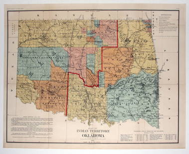
George Catlin Indian Localities in 1833 map
George Catlin Sale History
View Price Results for George CatlinRelated Maps & Atlases
More Items from George Catlin
View MoreRecommended Transportation & Travel Collectibles
View More


Item Details
Description
George Catlin.
Outline map of Indian localities in 1833.
Original engraving from The George Catlin Indian Gallery part of the Annual Report of the Boards of Regents of the Smithsonian Institution published in 1886 in Washington by Government Printing Office, good condition.
Dimensions: 9" by 14 1/2"
Artist Name: George Catlin, Thomas Donaldson
Literature: Annual Report of the Boards of Regents of the Smithsonian Institution published in 1886 in Washington by Government Printing Office
Medium: colored engraving
Circa: 1886
Handling and shipping for USA is $5.
FOR INTERNATIONAL SHIPPING please ask for an estimate.
Buyer's Premium
- 0%
George Catlin Indian Localities in 1833 map
Estimate $500 - $1,000
1 bidder is watching this item.
Get approved to bid.
Shipping & Pickup Options
Item located in Bradenton, FL, usOffers In-House Shipping
Payment
Accepts seamless payments through LiveAuctioneers

Related Searches
TOP


![[MAPS]. HOMANN, Johann Baptist, HOMANN HEIRS, and Georg Matthäus SEUTTER. [Composite Atlas].: [MAPS]. HOMANN, Johann Baptist (1663-1724), HOMANN HEIRS, and Georg Matthäus SEUTTER (1678-1757). [Composite Atlas]. [Nuremberg, Augsburg, and others: Homann Heirs and others, maps dated between](https://p1.liveauctioneers.com/197/329395/177650530_1_x.jpg?height=310&quality=70&version=1715364962)


