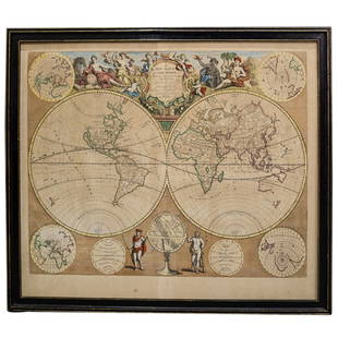
Wells' world map with California an Island 1700
Similar Sale History
View More Items in Maps & AtlasesRelated Maps & Atlases
More Items in Maps & Atlases
View MoreRecommended Transportation & Travel Collectibles
View More


Item Details
Description
Author: Wells, Edward
Title: A New Map of the Terraqueous Globe according to the Ancient Discoveries and most general Divisions of it into Continents and Oceans
Place Published: London
Publisher:
Date Published: 1700
Description:
Copper-engraved map, later hand coloring. 37x51 cm (14¼x20").
Attractive double hemisphere map showing California as an Island. This is one of a pair of maps Wells included in his atlas - this one depicting the world as known to the ancients. North America is noted as perhaps being "no other, than the Insular Atlantis of the Ancients." The map is surrounded by engraved scenes including the royal coat of arms and a dedication to His Highness William, Duke of Gloucester who was attending Oxford where Wells was a teacher of mathematics and geography and who appears with his tutor under the tree on the right. On either side of the dedication are small landscapes, one of ships arriving in the New World and one of the Radcliffe Camera in Oxford. Engraved by Michael Burghers.
Condition
Buyer's Premium
- 30%
Wells' world map with California an Island 1700
Shipping & Pickup Options
Item located in Berkeley, CA, usPayment


![1703 Scherer - World Map [California as an Island]: Title: World Map [without title] "Map maker: Heinrich Scherer, Atlas Marianus" "Place and Year: Munich, 1703" "Dimensions: 23.6 x 35.5 cm (9.3 x 14 in)" "Technique: Copperplate engraving" "Coloring: U](https://p1.liveauctioneers.com/5584/112867/57947644_1_x.jpg?height=310&quality=70&version=1511920104)


![Bien: Antique Map of California as Island, 1889: Wheeler, George M[ontague]. . Washington: Julius Bien, Photo-lithograph, 1889. Quarto, one leaf. Fine. This is the map showing California as an island, and the northern part of present day Mexico and](https://p1.liveauctioneers.com/5584/107399/55057770_1_x.jpg?height=310&quality=70&version=1501794677)


![1894 Johnston Map of Oceania [verso] Island in the Indian Ocean and Near Africa -- Oceania [verso]: Title: 1894 Johnston Map of Oceania [verso] Island in the Indian Ocean and Near Africa -- Oceania [verso] Madagascar; Mauritius; Seychelles; Cape Town; St. Helena and Ascension Islands; Socotra; Aden](https://p1.liveauctioneers.com/5584/328338/176911535_1_x.jpg?height=310&quality=70&version=1715113718)


![[Maps] Martin Zeiler, Itinerarium Italiae, 1640: [Maps] Martin Zeiler, Itinerarium Italiae, 1640, Martini Zeilleri. Itinerarium Italiae Nov-Antiquae: oder, Raiss-Beschreibung durch Italien, Matthaus Merian, Frankfurt, 40 plates, most double-page, in](https://p1.liveauctioneers.com/188/326797/176317459_1_x.jpg?height=310&quality=70&version=1713847031)
![[Maps] Gio. Ant. Magnini, Italia, 1620: [Maps] Gio. Ant. Magnini, Italia, 1620, Giovanni Antonio Magnini. Italia, data in luce da Fabio suo figliuolo al Serenissimo Ferdinado Gonzaga Duca di Matoua edi Monserrato etc. Bologna, for Sebastian](https://p1.liveauctioneers.com/188/326797/176317457_1_x.jpg?height=310&quality=70&version=1713847031)


![[MAP]. TODESCHI, Pietro. [Nova et Acurata Totius Americae Tabula auct. G.I. Blaeu] America quarta: [MAP]. TODESCHI, Pietro. [Nova et Acurata Totius Americae Tabula auct. G.I. Blaeu] America quarta pars orbis quam plerunq, nuvum orbem appellitant primo detecta est anno 1492 a Christophoro Columbo...](https://p1.liveauctioneers.com/197/329395/177650542_1_x.jpg?height=310&quality=70&version=1715364962)


