


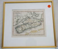
MAP OF NOVA SCOTIA DE VAUGONDY
Similar Sale History
View More Items in Wine & Spirits


![GERARD, publisher. Collection de douze vues de Waterloo: [Collection de douze vues de Waterloo]. [Brussells: Gerard, c1845]. Oblong. Colored views of Waterloo and large folding map "Plan de la bataille de Waterloo 18 Juin 1815". Oblong f](https://p1.liveauctioneers.com/4473/89380/45682128_1_x.jpg?height=310&quality=70&version=1464303660)


![Mapa Historico Pintoresco... Cuba... [ca. 1853].: [New World/Caribbean] MAPA HISTORICO PINTORESCO MODERNO DE LA ISLA DE CUBA. [Bernardo May, ca. 1853]. Folding map with roads, rails, and towns. Table of longitude, latitude, and distance between citie](https://p1.liveauctioneers.com/179/82189/42599756_1_x.jpg?height=310&quality=70&version=1447864785)


Related Wine & Spirits


More Items in Wine & Spirits
View More


Recommended Collectibles
View More


![George Washington Signed Discharge: Partly printed discharge document signed by George Washington, as Commander in Chief of the Armies of the United States. Newburgh, [New York], 4 January 1783. 1 page, ## x ## in. Undersigned by Washin](https://p1.liveauctioneers.com/7226/322253/173251475_1_x.jpg?height=310&quality=70&version=1710004847)
![[Ambrotype] Texas Confederate Soldier: Sixth plate ambrotype. Full leatherette case. Portrait of a possible Texas Confederate soldier. A silver star device was used to pin up the brim of his light-toned headgear, a look often seen in image](https://p1.liveauctioneers.com/7226/322253/173251509_1_x.jpg?height=310&quality=70&version=1710004847)


![Captured Bowie Knife w/ Period Note of Provenance: Captured Confederate D-hilt Bowie knife. [Kenansville, North Carolina]: [Louis Froelich factory]. With original metal and leather sheath with affixed period notes. First note with only remnants. Secon](https://p1.liveauctioneers.com/7226/325455/175169154_1_x.jpg?height=310&quality=70&version=1712370394)


Item Details
Description
Brilliant hand colored map of Nova Scotia, depicting Port Royal, the oldest European settlement in Canada. Professionally framed and matted. In frame 13 1/4"x12 1/4"x1/2". Weight 1 pd 9 oz. Gilles Robert de Vaugondy (1688-1766) was the head of a leading family of geographers in eighteenth century France. Gilles got his start when he jointly inherited the shop of Pierre-Moullart Sanson, grandson of the famous geographer Nicholas Sanson. The inheritance included the business, its stock of plates, and a roller press. In 1760 Gilles became geographer to King Louis XV. His son, Didier Robert de Vaugondy (ca. 1723-1786), was also a geographer and the two worked together. They were known for their exactitude and depth of research. In 1757, they produced the Atlas Universel, considered an authority for many years. PROVENANCE: The Estate of Edwin Joseph Hamblet, Portland, Maine
Condition
good
Buyer's Premium
- 18% up to $50,000.00
- 15% up to $1,000,000.00
- 10% above $1,000,000.00
MAP OF NOVA SCOTIA DE VAUGONDY
Estimate $200 - $300
5 bidders are watching this item.
Shipping & Pickup Options
Item located in Mt. Pleasant, SC, usOffers In-House Shipping
Local Pickup Available
Payment
Accepts seamless payments through LiveAuctioneers

TOP