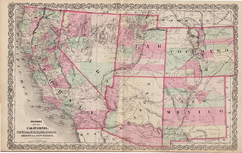
Early Map of Nevada, Utah, and Arizona 1862 [132959]
Similar Sale History
View More Items in Maps & Atlases
Related Maps & Atlases
More Items in Maps & Atlases
View MoreRecommended Transportation & Travel Collectibles
View More
![Early Map of Nevada, Utah, and Arizona 1862 [132959]](https://p1.liveauctioneers.com/2699/202326/102449216_1_x.jpg?quality=1&version=1620573769&width=486)
![Early Map of Nevada, Utah, and Arizona 1862 [132959]](https://p1.liveauctioneers.com/2699/202326/102449216_1_x.jpg?quality=80&version=1620573769)
Item Details
Description
This map is not dated but thought to be printed in 1862. Nevada is shown with about five counties including Lake County shared with California, established in 1961. This county was later called Roop County and later still Washoe County, Nevada. The town of Austin, Nevada is not listed, the Pony Express trails are marked and no references are made to railroads. Arizona and Utah are equally limited for county designations. Chipping of right edge, see photos for details.Date: Country (if not USA): State: NevadaCity: Provenance:
Buyer's Premium
- 25%
Early Map of Nevada, Utah, and Arizona 1862 [132959]
Estimate $300 - $400
1 bidder is watching this item.
Shipping & Pickup Options
Item located in Reno, NV, usOffers In-House Shipping
Local Pickup Available
Payment

Related Searches
TOP


![1877 Mitchell Map of Utah and Nevada [verso] Arizona and New Mexico -- County Map of of Utah and: Title: 1877 Mitchell Map of Utah and Nevada [verso] Arizona and New Mexico -- County Map of of Utah and Nevada [verso] County Map Arizona and New Mexico Cartographer: S Mitchell Year / Place: 1877 Phi](https://p1.liveauctioneers.com/5584/293457/155766077_1_x.jpg?height=310&quality=70&version=1687903812)
![1876 Mitchell Map of Utah and Nevada [verso] Arizona: Title/Content of Map: 1876 Mitchell Map of Utah and Nevada [verso] Arizona and New Mexico -- County Map of of Utah and Nevada [verso] County Map Arizona and New Mexico Date: 1876 Philadelphia Cartogra](https://p1.liveauctioneers.com/5584/137769/69881187_1_x.jpg?height=310&quality=70&version=1552435690)
![1869 Mitchell Map of Western US [verso] Mexico and: Title: 1869 Mitchell Map of Western US [verso] Mexico and Central America -- XIX California, Oregon, Idaho, Utah, Nevada, Arizona and Washington [verso] XX Mexico and Central America Cartographer: S M](https://p1.liveauctioneers.com/5584/188299/94765046_1_x.jpg?height=310&quality=70&version=1608072723)


![Large Map of California: Large Map of California With map of Arizona and Nevada [separately] on versos Cartographer: George Franklin Cram Dated: Circa 1900 Type: Color Lithograph Dimensions: 14](https://p1.liveauctioneers.com/5614/330257/178045314_1_x.jpg?height=310&quality=70&version=1716032806)
![Early California Map c1856 [179290]: Map of routes by militar detachments in spring of 1855 from SLC to SF. 4 different routes were examined by Cap.t Ingalls, Col. Stepto, Lt Mowry. Printed by Akerman NY. Detail has the appearance of bei](https://p1.liveauctioneers.com/2699/331495/178785754_1_x.jpg?height=310&quality=70&version=1717094933)
![Nord America, Westindien, 1862 Map [179350]: Nord (North) AmericaÓ by Westindien, folded, canvas backed, in original slip case, 1862. Only shows a few of the major towns in California such as San Francisco and Sacramento, very little else about](https://p1.liveauctioneers.com/2699/331495/178785792_1_x.jpg?height=310&quality=70&version=1717094933)


![Pyramid Lake Print Pair & 1885 NM & UT Territory Map [179398]: 1855 J H Colton hand colored map of New Mexico and Utah Territories, complete with Pyramid Lake in a shape that is very different as compared to the lake today. Did the cartographer mess up or has the](https://p1.liveauctioneers.com/2699/331495/178785761_1_x.jpg?height=310&quality=70&version=1717094933)


![[MAPS]. HOMANN, Johann Baptist, HOMANN HEIRS, and Georg Matthäus SEUTTER. [Composite Atlas].: [MAPS]. HOMANN, Johann Baptist (1663-1724), HOMANN HEIRS, and Georg Matthäus SEUTTER (1678-1757). [Composite Atlas]. [Nuremberg, Augsburg, and others: Homann Heirs and others, maps dated between](https://p1.liveauctioneers.com/197/329395/177650530_1_x.jpg?height=310&quality=70&version=1715364962)
![[MAP]. TODESCHI, Pietro. [Nova et Acurata Totius Americae Tabula auct. G.I. Blaeu] America quarta: [MAP]. TODESCHI, Pietro. [Nova et Acurata Totius Americae Tabula auct. G.I. Blaeu] America quarta pars orbis quam plerunq, nuvum orbem appellitant primo detecta est anno 1492 a Christophoro Columbo...](https://p1.liveauctioneers.com/197/329395/177650542_1_x.jpg?height=310&quality=70&version=1715364962)

![[MAP]. ORTELIUS, Abraham. Americae Sive Novi Orbis, Nova Descriptio. 1573.: [MAP]. ORTELIUS, Abraham (1527-1598). Americae Sive Novi Orbis, Nova Descriptio. Antwerp, 1573. Engraved map with hand-coloring. Framed and double glazed, visible area 375 x 521 mm (unexamined out of](https://p1.liveauctioneers.com/197/329395/177650534_1_x.jpg?height=310&quality=70&version=1715364962)


![Set of Twelve Satirical Anthropomorphic Maps of Europe: [SATIRICAL MAPS] A set of twelve satirical anthropomorphic maps of Europe. London: circa 1868. A set of 12 (believed complete) lithographed maps by Vincent Brooks, Day & Son, London, each offering](https://p1.liveauctioneers.com/292/330597/178279264_1_x.jpg?height=310&quality=70&version=1716409282)


![[MAP]. ORTELIUS, Abraham. Turcici Imperii Descriptio.1592.: [MAP]. ORTELIUS, Abraham (1527-1598). Turcici Imperii Descriptio. Antwerp, 1592. Engraved map with hand-coloring. Matted, framed, and double glazed, sight 406 x 521 mm (unexamined out of frame). Decor](https://p1.liveauctioneers.com/197/329395/177650538_1_x.jpg?height=310&quality=70&version=1715364962)
![[MAP]. ORTELIUS, Abraham. Romani Imperii Imago. 1592.: [MAP]. ORTELIUS, Abraham (1527-1598). Romani Imperii Imago. Antwerp, 1592. Engraved map with hand-coloring. Matted, framed, and double glazed, visible area 381 x 521 mm (unexamined out of frame). 6 de](https://p1.liveauctioneers.com/197/329395/177650537_1_x.jpg?height=310&quality=70&version=1715364962)
![[MAP]. SPEED, John. A New Mappe of the Romane Empire. 1676.: [MAP]. SPEED, John (ca 1551-1629). A New Mappe of the Romane Empire. London: Basset & Chiswell, 1676. Engraved map with hand-coloring. Framed and double glazed, sight 419 x 559 mm. Decorative cartouch](https://p1.liveauctioneers.com/197/329395/177650541_1_x.jpg?height=310&quality=70&version=1715364962)
![[MAP]. ORTELIUS, Abraham. Aevi Veteris, Typus Geographicus. 1601.: [MAP]. ORTELIUS, Abraham (1527-1598). Aevi Veteris, Typus Geographicus. Antwerp, 1601. Engraved map with hand-coloring. Matted, framed, and double glazed, visible area 343 x 470 mm (unexamined out of](https://p1.liveauctioneers.com/197/329395/177650532_1_x.jpg?height=310&quality=70&version=1715364962)


