


Older Maps of San Francisco Bay Area and Surrounding
Similar Sale History
View More Items in Maps & Atlases


![Beautiful map of S.F. Bay Region 1873: Heading: (California - San Francisco Bay Area) Author: California, State Geological Survey Title: Map of the Region Adjacent to the Bay of San Francisco... Place Published: [n.p.] Publisher: Date](https://p1.liveauctioneers.com/642/204898/103986346_1_x.jpg?height=310&quality=70&version=1621652446)


Related Maps & Atlases


![Carte du Golphe de Bengale'. Bay of Bengal. India Burma Ceylon. BELLIN 1746 map: CAPTION PRINTED BELOW PICTURE: Carte du Golphe de Bengale tiré de la Carte de l'Océan Oriental, Publiée par Ordre de Mgr le Comte De Maurepas [Map of the Bay of Bengal] DATE PRINTED: 17](https://p1.liveauctioneers.com/5584/329387/177649439_1_x.jpg?height=310&quality=70&version=1715717898)


![[MAP]. ORTELIUS, Abraham. Africae Tabula Nova. 1592.: [MAP]. ORTELIUS, Abraham (1527-1598). Africae Tabula Nova. Antwerp, 1592. Engraved map with hand-coloring. Matted, framed, and double glazed, visible area 406 x 533 mm (unexamined out of frame). Strap](https://p1.liveauctioneers.com/197/329395/177650533_1_x.jpg?height=310&quality=70&version=1715364962)
![Index Map to the Charts Published by the U.S. Coast and Geodetic Survey Gulf Coast Cape San Blas to: Title: Index Map to the Charts Published by the U.S. Coast and Geodetic Survey Gulf Coast Cape San Blas to Ship Shoal [Gulf Coast] Cartographer: COLONNA, B. A. | H. L. THOMPSON | J. P. COX Publisher:](https://p1.liveauctioneers.com/5584/329422/177662157_1_x.jpg?height=310&quality=70&version=1715717898)


More Items in Maps & Atlases
View More


![[MAP]. TODESCHI, Pietro. [Nova et Acurata Totius Americae Tabula auct. G.I. Blaeu] America quarta: [MAP]. TODESCHI, Pietro. [Nova et Acurata Totius Americae Tabula auct. G.I. Blaeu] America quarta pars orbis quam plerunq, nuvum orbem appellitant primo detecta est anno 1492 a Christophoro Columbo...](https://p1.liveauctioneers.com/197/329395/177650542_1_x.jpg?height=310&quality=70&version=1715364962)


![[MAPS]. HOMANN, Johann Baptist, HOMANN HEIRS, and Georg Matthäus SEUTTER. [Composite Atlas].: [MAPS]. HOMANN, Johann Baptist (1663-1724), HOMANN HEIRS, and Georg Matthäus SEUTTER (1678-1757). [Composite Atlas]. [Nuremberg, Augsburg, and others: Homann Heirs and others, maps dated between](https://p1.liveauctioneers.com/197/329395/177650530_1_x.jpg?height=310&quality=70&version=1715364962)


Recommended Transportation & Travel Collectibles
View More


Item Details
Description
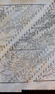
A collection of 27 fascinating maps from the early 1900's, reprinted in the 1920's showing regions around the Bay Area. They show rail routes for both the Western Pacific and Southern Pacific Railroads. Names of areas like the Santa Clara Valley, were then known as Valle De San Jose, Canada De Los Vaqueros and others. One map shows a section of Suisun Bay named Honker Bay and several islands in the Delta. Maps measure about 16"x 20" and are in very readable and displayable shape. Please see photos for more details and condition.Date: 1900'sCountry (if not USA): State: CaliforniaCity: San FranciscoProvenance:
Buyer's Premium
- 25%
Older Maps of San Francisco Bay Area and Surrounding
Estimate $150 - $250
5 bidders are watching this item.
Shipping & Pickup Options
Item located in Reno, NV, usOffers In-House Shipping
Local Pickup Available
Payment

Related Searches
TOP