


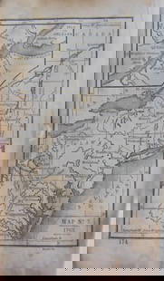
Map and Profile of the Canada De Las Uvas;...
Similar Sale History
View More Items in Maps & Atlases


![MAP, Eastern Canada, Direccion de Hidrografia: Newfoundland & Labrador. Direccion de Hidrografia, [On 2 Sheets] Carta Esferica en dos Hojas del Banco y la Isla de Terranova con Parte de la Costa de Labrador..., 1840 (dated). Black & White. A highl](https://p1.liveauctioneers.com/6576/263260/137251069_1_x.jpg?height=310&quality=70&version=1664399834)


![[ANTIQUE MAP] VAUGONDY NOUVELLE FRANCE-CANADA 1755: [ANTIQUE MAPS] de VAUGONDY, Robert. "CANADA PARTIE DE L'AMERIQUE SEPTENT QUI COMREND LA NOUVELLE FRANCE OU LE CANADA"Circa 1755. 61x47cm. Frame not included. Map will be removed from frame and securel](https://p1.liveauctioneers.com/8321/253807/131946553_1_x.jpg?height=310&quality=70&version=1657219161)


Related Maps & Atlases


More Items in Maps & Atlases
View More
![[MAP]. TODESCHI, Pietro. [Nova et Acurata Totius Americae Tabula auct. G.I. Blaeu] America quarta: [MAP]. TODESCHI, Pietro. [Nova et Acurata Totius Americae Tabula auct. G.I. Blaeu] America quarta pars orbis quam plerunq, nuvum orbem appellitant primo detecta est anno 1492 a Christophoro Columbo...](https://p1.liveauctioneers.com/197/329395/177650542_1_x.jpg?height=310&quality=70&version=1715364962)


![[MAPS]. HOMANN, Johann Baptist, HOMANN HEIRS, and Georg Matthäus SEUTTER. [Composite Atlas].: [MAPS]. HOMANN, Johann Baptist (1663-1724), HOMANN HEIRS, and Georg Matthäus SEUTTER (1678-1757). [Composite Atlas]. [Nuremberg, Augsburg, and others: Homann Heirs and others, maps dated between](https://p1.liveauctioneers.com/197/329395/177650530_1_x.jpg?height=310&quality=70&version=1715364962)


![[MAP]. ORTELIUS, Abraham. Americae Sive Novi Orbis, Nova Descriptio. 1573.: [MAP]. ORTELIUS, Abraham (1527-1598). Americae Sive Novi Orbis, Nova Descriptio. Antwerp, 1573. Engraved map with hand-coloring. Framed and double glazed, visible area 375 x 521 mm (unexamined out of](https://p1.liveauctioneers.com/197/329395/177650534_1_x.jpg?height=310&quality=70&version=1715364962)
![Set of Twelve Satirical Anthropomorphic Maps of Europe: [SATIRICAL MAPS] A set of twelve satirical anthropomorphic maps of Europe. London: circa 1868. A set of 12 (believed complete) lithographed maps by Vincent Brooks, Day & Son, London, each offering](https://p1.liveauctioneers.com/292/330597/178279264_1_x.jpg?height=310&quality=70&version=1716409282)


![[MAP]. ORTELIUS, Abraham. Turcici Imperii Descriptio.1592.: [MAP]. ORTELIUS, Abraham (1527-1598). Turcici Imperii Descriptio. Antwerp, 1592. Engraved map with hand-coloring. Matted, framed, and double glazed, sight 406 x 521 mm (unexamined out of frame). Decor](https://p1.liveauctioneers.com/197/329395/177650538_1_x.jpg?height=310&quality=70&version=1715364962)
Recommended Transportation & Travel Collectibles
View More

![[FLAGS]. 31-star American parade flag. Ca 1850-1859.: [FLAGS]. 31-star American parade flag. Ca 1850-1859. 22 x 36 1/2 in. cotton flag with 31 printed stars, configured in a double medallion surrounding a much larger central star, that is haloed in both](https://p1.liveauctioneers.com/197/329785/177758218_1_x.jpg?height=310&quality=70&version=1715625218)


Item Details
Description
"by Lieut. R.S. Williamson, topl. emngrs. assisted by Lieut J.G. Parke, topl. engrs. and Mr. Isaac Williams Smith... 1853." Map showing explorations and surveys for a railroad route in California to connect with the routes proposed near the 32d and 35th parallels. Tejon in west and Great Basin in east. Shows topo., Tributary of the Santa Clara River, Packtrail to Los Angeles, etc. With arrow like compass needle. Minor fold browning & repair.
Reserve: $140.00
Shipping:
Your purchase is protected:
Photos, descriptions, and estimates were prepared with the utmost care by a fully certified expert and appraiser. All items in this sale are guaranteed authentic.
In the rare event that the item did not conform to the lot description in the sale, Jasper52 specialists are here to help. Buyers may return the item for a full refund provided you notify Jasper52 within 5 days of receiving the item.
Condition
Good
Buyer's Premium
- 15%
Map and Profile of the Canada De Las Uvas;...
Estimate $150 - $200
1 bidder is watching this item.
Get approved to bid.
Shipping & Pickup Options
Item located in Tennessee, US$18 shipping in the US
Payment
See More Items From This Jasper52 Seller

Auction Curated By

Maps Expert
Related Searches
TOP