Sold2020Wyld: South America Map by Queen Victoria’s GeographerTitle/Content of Map: Wyld: South America Map by Queen Victoria’s Geographer Date Printed: 1843, London Cartographer: James Wyld Size: 9" x 11 3/4" The elegantly designed and highly detailed map ofSee Sold Price
Sold2023AMERICA H. Moll Geographer 1732 MapHerman Moll 1732 Map of the Americas, North and South America with California depicted as an island. Hand Colored engraving 8 1/2 x 11 in Matt.See Sold Price
Sold2023Antique French Engraving Felix Delamarche map South America 1838Charles-Francois Delamarche (1740-1817), the founder of the family firm was one of the most important French geographers and mapmakers of the second half of the eighteenth century. Successor to NicolaSee Sold Price
Sold2022Large Antique French 1748 D'anville Map of South America in a set of 3Jean-Baptiste Bourguignon d’Anville (1697-1782) was one of the foremost French geographers of the eighteenth century. He carried out rigorous research in order to create his maps, which greatlySee Sold Price
Sold20201860 Map of EgyptAuthor: Stockley Title: 1860 Map of Egypt Medium: Ink on Paper Dimensions: 9"X10.5" Description: Map of Egypt dated 1860. Engraved by James Stockley. Published by James Wyld engraver to Queen VictoriaSee Sold Price
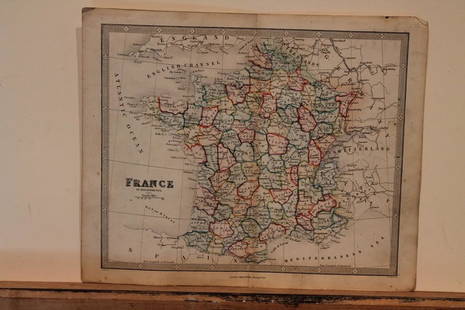
Sold20211860 Map of FranceAuthor: Stockley Title: 1860 Map of France Medium: Ink on Paper Dimensions: 10.5"X9" Map of France dated 1860. Engraved by James Stockley. Published by James Wyld engraver to Queen Victoria in CharingSee Sold Price
Sold2018Basin of The Pacific by Jas. Wyld,Title/Content of Map: Basin of The Pacific by Jas. Wyld, Date Printed: 1840 Cartographer: WYLD, JAS. Size: 22.1X33.1 "Geographer to the Queen & H.R.H. Prince Albert..." Very detailed with printed sheeSee Sold Price
Sold2023c 1706 Pieter Van Der Aa North + South America Map as 1st Discovered by ColumbusHistoric Maps 1706 North & South America Map Discovered by Columbus First Voyage Published by Dutch Map Pieter Van Der Aa (1659-1733) c. 1706-1708, Original Map of North & South America (translated) tSee Sold Price
Sold20221646 Voyages West Indies South America Map PlatesHistorisch journael vande voyage ghedaen met ses schepen, uytghereed zijnde door de . Oost-Indische Compaignie . omme te varen door de Strate Magallanes naer de Molucques . Onder 't gebiedt van . JoriSee Sold Price
Sold2020Carte D’Amerique North & South America MapOn laid paper, by on your expertise, we can provide additional photos if necessary , back in not accessible Frame 31 x 27See Sold Price
Sold2023Propaganda Poster South America Map Indian Culture Principal TribesOriginal vintage poster featuring a pictorial map of the Areas of Indian Culture and Principal Tribes in South America marked in the geographical and cultural groups of the Antillean, Chibchan, AmazonSee Sold Price
Sold2017South America Map, 1844South America, Sheet I., Ecuador, New Granada, Venezuela And Parts Of Brazil And Guyana, 1844 Map. This map was originally published by The Society for the Diffusion of Useful Knowledge in 1842; thisSee Sold Price
Sold2019Bellin: Beautifully Designed South America Map, 1754Cartographer: Bellin / Prevost d'Exiles Place/Date: Paris / 1754 Size: 6" x 8" Condition: b&w; light overall age toning; a strong, dark impression Bellin's beautifully designed and engraved map of SouSee Sold Price
Sold2019Pinkerton: Grand South America MapMap Title: South America Cartographer: Pinkerton Place/Date: London / 1811 Size: 19 1/2" x 27" Condition: wash color; light overall age toning, repaired splits in centerfold margins An excellent impreSee Sold Price
Sold2020Greenleaf: Scarce 1842 South America MapTitle/Content of Map: Greenleaf: Scarce 1842 South America Map Date Printed: 1842, Brattleboro (Vermont) Cartographer: Jeremiah Greenleaf Size: 10 3/4" x 12 1/2" A beautifully colored exemplar of GreeSee Sold Price
Sold2022Antique Map - Map of South America - Map of Brazil - George SwanstonInteresting antique map from ‘A Gazetteer of the World or Dictionary of Geographical Knowledge’ by A. Fullarton & Co. Technique: Hand colored steel engraving. Date: 1858. Artist: George HSee Sold Price
Sold20231855 US Naval Astronomy Expedition South America MAPS CHILE Argentina PERU1855 US Naval Astronomy Expedition South America MAPS CHILE Argentina PERU James Melville Gilliss was an astronomer, officer in the US Navy and founder of the United States Naval Observatory. US NavalSee Sold Price
Sold20231818 BRAZIL Koster Voyages in South America MAPS Portuguese History SLAVERY 2v1818 BRAZIL Koster Voyages in South America MAPS Portuguese History SLAVERY 2v Henry Koster was an early 19th-century English explorer known for his, albeit short, life in Brazil. While there, KosterSee Sold Price
Sold2023Pair of North & South America Maps Atlas Universel Illustre'Pair of North & South America Maps Atlas Universel Illustre', Pelissier. Imp. de Lemercier, Paris. The Sight for each measures 10 1/2" x 15 1/8", and the Frame for each measures 21 3/4" x 26 1/2". PleSee Sold Price
Sold2019Bartholomew, John 1922 South America Maps (3)Large Lithograph Maps Published 1922 by The Times, London for "The Times Survey Atlas of the World" Maps by John George Bartholomew of the Edinburgh Geographical Institute. Centre fold as issued. PapeSee Sold Price
Sold20211826 Humboldt/Brue Map of Northwest South America --Title: 1826 Humboldt/Brue Map of Northwest South America -- Map of Columbia Compiled by A H Brue from the Astronomical Observations and Toographical Notices of Mr. Alex'r. de Humboldt Cartographer: HuSee Sold Price
Sold2018Le Rouge: South America 1748Map: Amerique Meridionale Cartographer: Le Rouge Place & Date: Paris / 1748 Size: 11 3/4" x 8 1/4" Condition: outline color; light overall age toning Le Rouge's fascinating South America map from hisSee Sold Price
Sold2018Rossi: South America / OceaniaThe distinctively engraved South America map from Nuovo Atlante di Geografia Universale extends across the Pacific to include New Zealand; features many new towns and settlements, with legends and plaSee Sold Price
3 days LeftRich Penn AuctionsDecorative Art, map of South America, late 18th C., framed & matted, Exc cond, 24"H x 20"W overall.$50
6 days LeftJasper521822 MAP of SOUTH AMERICA GEOGRAPHICAL STATISTICAL HISTORICAL antique 17.5x 22"$75
2 hrs LeftUniversity ArchivesScarce Early Printing: "An Account of the European Settlement in America in 6 Parts..."$100
May 30Forum Auctionsd'Anville (Jean Baptiste Bourguignon) [Untitled Composite Atlas with 102 map sheets], [probably£2,000
1 day LeftPotter & Potter AuctionsPOLAND, Edwin Christian (1903 – 1991). The Evergreen Playgr...$200
20 hrs LeftOriental Art AuctionsAL-IDRISI AND ROGER II, A MAP OF ASIA IN NUZHAT AL-MUSHTAQ, 17TH CENTURY€4,000
Jun 02Schilb Antiquarian Rare Books1831 PIRATES in America TORTUGA Capt Morgan Buccaneers Drake Cavendish Voyages$2(2 bids)
3 days LeftTHOS. CORNELL GALLERIES, LTD.GROUP OF ANTIQUE AND VINTAGE MAPS, INC.. NORTH AND SOUTH AMERICA, WORLD MAPS, LOSSES THROUGHOUT,$100(1 bid)
May 30NY Elizabeth ANTIQUE MAP-ILLUSTRATED FLORAL ILLUSTRATION 1761 NEW DICTIONARY OF TRADE AND COMMERCE R. ROTH$50
2 hrs LeftUniversity ArchivesQueen Victoria Approves British Act to Work with the United States to Suppress the African Slave$300
4 days LeftHeartland Artifact Auctions Inc4 1/4" Pre-Columbian Corn God Effigy, Motley COA, found in South America$60(4 bids)
4 days LeftHeartland Artifact Auctions Inc2 1/2" Pre-Columbian Jadeite Tube Bead, Motley COA, found in South America$26(3 bids)
4 days LeftHeartland Artifact Auctions Inc3 15/16" Pre-Columbian Canopa, Motley COA, found in Peru, South America$110(3 bids)
4 days LeftHeartland Artifact Auctions Inc3 9/16" Pre-Columbian Copper Mace Head, Motley COA, found in South America$55(2 bids)


![d'Anville (Jean Baptiste Bourguignon) [Untitled Composite Atlas with 102 map sheets], [probably (1 of 3)](https://p1.liveauctioneers.com/5458/329231/177514974_1_x.jpg?height=282&quality=70&version=1715269091)


