Sold2017WILLIAM KIP AFTER JOHN NORDEN HAND COLORED MAPWILLIAM KIP AFTER JOHN NORDEN, HAND COLORED MAP, H 11", W 14 7/8", "CANTIUM QUOD NUNC KENT":Parts of Essex and Parts of Middlesex, London. Hand colored. Retailed by H. S. Ward, 2 Parkside, Sussex. FraSee Sold Price
Sold2019* SAXTON, Christopher (ca 1540-ca 1610), and William* SAXTON, Christopher (ca 1540-ca 1610), and William KIP (fl.1598-1610). Flint Comitatus quem ordovices olim Incoluerunt. [London, 1607]. Hand-colored engraved map of Flint, image 265 x 320 mm (320 xSee Sold Price
Sold2023Antique Maps of Hertfordshire (2)Hertfordshire by Robert Morden. London, Early 18th C. With Hertfordiae Comitatus a cattifuclanis olim inhabitatus (Hertfordshire) by John Norden, engraved by William Kip, c. 1637. Largest 16" x 18 1/2See Sold Price
Sold2022JOHN SPEED 17TH C. MAP, SPAIN.John Speed map, “Spaine Newly Described with Many Additions, both in the Attires of the People & the Setuations of their Cheifest Cityes” engraved map, hand-colored (likely later), bordereSee Sold Price
Sold2021Rapkin, John 1857 HC Map of Siege of Sebastopol, CrimeaHand Colored Steel Engraved Map Published 1857, London for "England's Battles by Sea and Land..." by Lieut-Colonel Williams. Centre fold as issued. Drawn & Engraved by John Rapkin. Paper Size: 14 x 10See Sold Price
Sold2021Rapkin, John 1857 HC Map of Siege of Sebastopol, CrimeaHand Colored Steel Engraved Map Published 1857, London for "England's Battles by Sea and Land..." by Lieut-Colonel Williams. Centre fold as issued. Drawn & Engraved by John Rapkin. Paper Size: 14 x 10See Sold Price
Sold2016John Cary Map, "A New Map of China" 1801, hand coloredJohn Cary Map, "A New Map of China" 1801, hand colored engraving, 21-1/2" x 25-1/2" sheet, discoloration, especially at lower marginSee Sold Price
Sold2019Rapkin, John 1860 Hand Colored Map of the USAHand Colored Steel Engraved Map Published 1860 by The London Printing & Published Company, London for "The Royal Dictionary-Cyclopedia for Universal Reference" by Thomas Wright. Drawn & Engraved by JoSee Sold Price
Sold2020Rapkin, John 1860 Hand Colored Map of the USAHand Colored Steel Engraved Map Published 1860 by The London Printing & Published Company, London for "The Royal Dictionary-Cyclopedia for Universal Reference" by Thomas Wright. Drawn & Engraved by JoSee Sold Price
Sold20201778 Handcolored Map West Indies Gulf of Mexico1778 "The West Indies and Gulf of Mexico from the Latest and Best Observations", by John Lodge. Hand colored map. Fine, measures 15 x 9". Reserve: $80.00 Shipping: Domestic: Flat-rate of $5.00 to anywSee Sold Price
Sold2023Vintage John H. Martin Hand Colored Map of Nantucket "Soil Associations"Vintage John H. Martin Hand Colored Map of Nantucket "Soil Associations", color key showing the different soil types and locations of each on the island, by John H. Martin Harvard University. OverallSee Sold Price
Sold2021Antique John Speed Hand Colored Lancaster MapAntique John Speed Hand Colored "The Countie Pallatine of Lancaster Described and Divided Into Hundreds 1610" Map. The map features the portraits of Henry IIII, Henry V, Henry VI, and Henry VII underSee Sold Price
Sold2019Part of South Australia (Area around Adelaide)Title: Part of South Australia (Area around Adelaide) Printing Date: London, [c.1849] Cartographer: Tallis, John Medium: hand colored lithographed map Dimensions: 14 x 11 inches (355 x 280mm) AdditionSee Sold Price
Sold2018Christopher Saxton 1607 Map of ShropshireChristopher Saxton & William Hole 1607 hand colored map of Shropshire from Camden's Brittanica titled "Salopiae Comitatus quen Cornauii", sight view 11 1/4" x 14'See Sold Price
Sold2024John Speed 1676 Antique Hand Colored "Map of Virginia and Maryland" #2Antique 1676 hand-colored map of Virginia and Maryland engraved by Francis Lamb and republished by Thomas Basset & Richard Chriswell after John Speed's 1611 atlas. Good overall, apparent repairs, minoSee Sold Price
Sold2020Norden, John - William Kip Sussexia sive Southsex, olimc.1670, 30.5 x 40cm, Latin text to verso, some slight marginal worming, tape stain along left edge; [Idem] - Saxton, Christopher Norfolciae comitatus quem oliceni... c.1637, 33.5 x 39cm, verso blank,See Sold Price
Sold2023"Africa" by John Luffman & "Asia" Antique Handcolored Maps"Africa" by John Luffman & "Asia" Antique Handcolored Maps.See Sold Price
Sold2024Hand-Colored John Smith Map of VirginiaHand-colored John Smith Map of Virginia, dated 1608, a good early 19th c reproduction engraving, with notes on reverse, watercolorist signed lower right corner, well framed, sight 12 3/4" x 16 1/2"See Sold Price
Sold2020SPEED, JOHN. Bohemia.SPEED, JOHN. Bohemia. Hand-colored double-page engraved map of the Czech Republic with carte-a-figures and city plan border panels. 16¼x20½ inches sheet size, margins shaved to the neatline,See Sold Price
Sold2022William John Huggins Engraving Sir David ScottAfter William John Huggins (British, 1781-1845). Hand colored nautical engraving Sir David Scott. Engraved by E. Duncan. 12" x 18" (with frame 22" x 27"). Discoloration to paper.See Sold Price
Sold20231806 Hand Colored Map of Cornwall, John Cary1806 Map of Cornwall, England by John Cary (1755-1835). Copper plate map titled "A Map of Cornwall from the Best Authorities". Detailed hand colored map with Scilly Islands inset. Good condition, setSee Sold Price
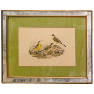
Sold202319th C. John Gould & William Hart Hand Colored LithographDESCRIPTION: Antique John Gould (English, 1804-1881) and William Matthew Hart hand colored ornithology lithograph. Depicting three vibrant Grey-capped Wagtails among details of grass and boulders andSee Sold Price
Sold2017Revolutionary War Map of the Battle of SaratogaAmerican Revolution 1780 Revolutionary War Map Engraved by William Faden 1780-Dated Revolutionary War, Hand-Colored Map entitled, “Plan of the Encampment and Position of the Army Under His Excelly.See Sold Price
Sold2022MAPS: John Speed (England, 1552-1629), threeMAPS: John Speed (England, 1552-1629), three hand-colored maps on paper: one a map of Suffolk with town plan of Ipswich, dated 1610 in block, described and divided into hundreds, inset plan of IpswichSee Sold Price
Jun 08Simpson Galleries, LLC.JODOCUS HONDIUS (1563-1612) A JACOBEAN MAP, "Northamptonshire," AMSTERDAM, 1610$150
Jun 01Trillium Antique Prints & Rare BooksBaird & Emory's Report on the United States and Mexican Boundary Survey - Volume with 25 Originally$200
Jun 07Freeman's | HindmanMURCHISON, Roderick Impey, Sir. The Silurian System. 1839. COMPLETE WITH VERY RARE HAND-COLORED$1,500
Jun 14DuMouchellesWilliam H. Gamble (American, B. 1863) Hand Colored Engraving, Ca. 1863, "County Map of Michigan And$50(1 bid)
Jun 08Early American History Auctionsc 1730 Hand-Colored Colonial Era Map of the Americas, California shown as an Island, Matted + Framed$500(1 bid)
Jun 08Early American History Auctions1720 Colonial Northumberland County Virginia Manuscript Deed and Map Plot$400
Jun 07Freeman's | HindmanCASSIN, John. Illustrations of the Birds of California, Texas, Oregon, British and Russian American.$500
Jun 09Worthington Galleries2 Framed Sharpe & Gould Hand-Colored Plate from BIRDS OF PARADISE (Monograph of the Paradiseidae)$200
Jun 14DuMouchellesEnglish Hand Colored Etching on Paper, Ca. 1820, Bare Knuckle Boxer David Hudson H 13" W 9.25"$100
Jun 14DuMouchellesWilliam Barker (American, 1770-1805) And Various Engravers Hand Colored Engraved Maps Ca. 18th/19th$50
Jun 01Trillium Antique Prints & Rare BooksJohn James Audubon's Birds of America - 7 Volume set with 500 Originally Hand-colored Lithographs,$30,000


![* SAXTON, Christopher (ca 1540-ca 1610), and William: * SAXTON, Christopher (ca 1540-ca 1610), and William KIP (fl.1598-1610). Flint Comitatus quem ordovices olim Incoluerunt. [London, 1607]. Hand-colored engraved map of Flint, image 265 x 320 mm (320 x](https://p1.liveauctioneers.com/197/138502/70223744_1_x.jpg?height=310&quality=70&version=1553021483)


![Part of South Australia (Area around Adelaide): Title: Part of South Australia (Area around Adelaide) Printing Date: London, [c.1849] Cartographer: Tallis, John Medium: hand colored lithographed map Dimensions: 14 x 11 inches (355 x 280mm) Addition](https://p1.liveauctioneers.com/5584/140407/71160553_1_x.jpg?height=310&quality=70&version=1556054096)


![Norden, John - William Kip Sussexia sive Southsex, olim: c.1670, 30.5 x 40cm, Latin text to verso, some slight marginal worming, tape stain along left edge; [Idem] - Saxton, Christopher Norfolciae comitatus quem oliceni... c.1637, 33.5 x 39cm, verso blank,](https://p1.liveauctioneers.com/94/169912/85619991_1_x.jpg?height=310&quality=70&version=1590766753)