Sold2021Early California/Nevada Desert Survey Maps (17)A group of 17 maps that chart the areas of desert in eastern California and Nevada. Sixteen of the maps measure 21"x 16" and one, showing the Kingman, Arizona and California southern desert regions meSee Sold Price
Sold2019U S Coast Survey 1896 Map. California Nevada Boundary"Boundary Survey between California and Nevada. Sheet 1" Lithograph Map Published 1896, Washington for "U.S. Coast and Geodetic Survey" Folds as issued. Rare. Paper Size: 20 x 19.5 inch (50 x 49cm) GoSee Sold Price
Sold2019U S Coast Survey 1896 Map. California Nevada Boundary"Boundary Survey between California and Nevada. Sheet 1" Lithograph Map Published 1896, Washington for "U.S. Coast and Geodetic Survey" Folds as issued. Rare. Paper Size: 20 x 19.5 inch (50 x 49cm) VeSee Sold Price
Sold2022U S Coast Survey 1896 LG Map. California & NevadaSheet No. 2 "Boundary Survey between California and Nevada" Large Lithograph Map Published 1896, Washington for "U.S. Coast and Geodetic Survey" Folds as issued. Paper Size:23 x 21.5 inch (58 x 55cm)See Sold Price
Sold20191872 1st ed Exploration Arizona Nevada California1872 1st ed Exploration Arizona Nevada California Mojave George Wheeler Survey The first official exploration report on the Mojave and Death Valleys! (Howes) George Wheeler was a 19th-century AmericanSee Sold Price
Sold2021Impressive & scarce map of N. Calif/Nevada, 1882Two-page map of Northern California, Nevada Territory and western portion of Utah from the extremely scarce 1882 Cram’s Unrivaled Family Atlas of the World. The only Cram atlas maps that were haSee Sold Price
Sold2018Weller: Antique Map of Roman Empire in the 4th CenturyTitle/Content of Map: Roman Empire (Eastern & Western) in The 4th Century. Date Printed: 1877 ca. Cartographer: WELLER, EDW. Publisher: G.P. PUTNAM'S SONS 1877 ca. NEW YORK Size: Quarto – 6.00 H x 8See Sold Price
Sold2023Scarce 1st ed. Tunison’s California, Oregon, Nevada, 1885Beautiful double-page map of California and western states, from the 1885 Tunison’s Peerles Universal Atlas of the World by H. C. Tunison. WorldCat lists this atlas as Tunison’s first atlaSee Sold Price
Sold2018U.S Coast Survey 1853 Map. Cortez Bank, California"Cortez Bank on the Western Coast of the United States" Electrotype Map Published 1843-65, Washington for "Report of the Superintendent of the U.S. Coast Survey..." Published under the supervision andSee Sold Price
Sold2019U S Coast Survey 1896 LG Map. West USA California Texas"Sketch of General Progress June 30. 1896." Showing Central and Western US, with part of Mexico. From Mississippi/Wisconsin through to West Coast. Large Lithograph Map Published 1896, Washington for "See Sold Price
Sold20231855 Beckwith Map of Nevada and Northern California -- Map No. 4 From the Valley of the Mud Lakes toTitle: 1855 Beckwith Map of Nevada and Northern California -- Map No. 4 From the Valley of the Mud Lakes to the Pacific Ocean from Explorations and Surveys Made Under the Direction of Hon. Jefferson DSee Sold Price
Sold2017VINTAGE MAPS AND MOREVINTAGE MAPS - UTAH OIL REFINING COMPANY - WESTERN STATES - SHELL - MAP OF NEVADA/UTAH AND ARIZONA/NEW MEXICO - RPM MOTOR OIL MAP - CALIFORNIA POINTS OF INTEREST AND TOURING MAP - AND MANY MORE - ALLSee Sold Price
Sold2019USA 1911 Lot of 12 State Maps incl Texas & CaliforniaIncl Utah, New Jersey, Nebraska, Washington, Arkansas, Oregon, Texas, California and Nevada, Maine, Maryland and Delaware, Massachusetts, and South Eastern Pennsylvania. Lithograph Maps Published 1911See Sold Price
Sold2019U S Coast Survey 1896 Large Map. Colorado Utah Kansas"Triangulation between Western Kansas and Eastern Utah along or near the 39th Parallel" Large Lithograph Map Published 1896, Washington for "U.S. Coast and Geodetic Survey" Folds as issued. Rare. PapeSee Sold Price
Sold2024Lawson's Survey Map Upper Calif Mines, c1848 [178902]Lawson's map from actual survey of the gold, silver and Quicksilver regions of upper California exhibiting the mines, diggings, roads, paths, houses, mills, stores, missions etc. by JT Lawson togetherSee Sold Price
Sold2020Bartholomew, John 1922 Lot of 4 Large Maps. EuropeIncl Europe Political, Orography/Vegetation/Races/Population, Western Europe Politcal, Eastern Political. Large Lithograph Maps Published 1922 by The Times, London for "The Times Survey Atlas of the WSee Sold Price
Sold2020Post Route Map of California and Nevada (109790)Post Route Map of the States of California and Nevada, dated September 1907. Paper map glued to a canvas backing attached to a wooden rod at the top. Lower left corner of the map has been damaged andSee Sold Price
Sold2024Mountaineering in the Sierra Nevada by King, 1874 [179333]1874 Mountaineering in the Sierra Nevada by Clarence King. Yosemite, Mt. Whitney, Shasta etc. 308pp with foldout California map with 1.5" tear. Binding has wear. CaliforniaSee Sold Price
Sold2022Scarce Johnson map of the Great Western states, 1864Antique map of California, Nevada, Utah, Colorado, New Mexico, and Arizona. Published during a great time of expansion and change in the U.S. West, as well as during the Civil War. Here Utah displaysSee Sold Price
Sold2023Scarce Johnson map of the Great Western states, 1864Authentic vintage map of California, Utah, Nevada, Colorado, New Mexico, and Arizona. Created during a great time of expansion and change in the western United States while the Civil War was still ragSee Sold Price
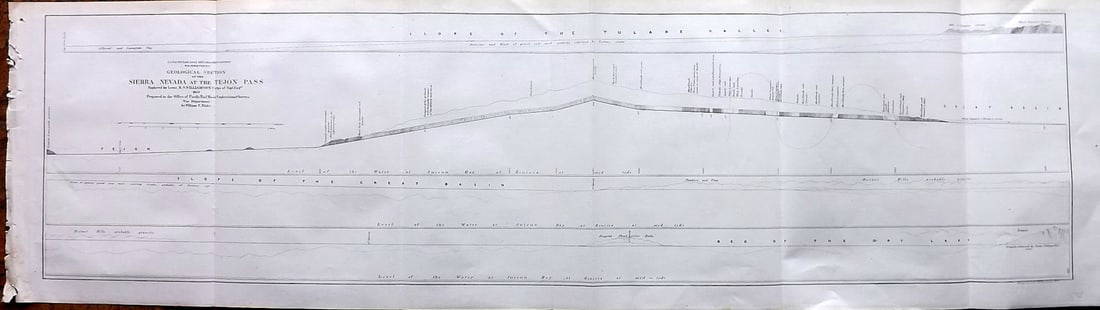
Sold2023Williamson, Lieut. R. S. 1856 LG Chart. California - Sierra Nevada & Tejon Pass"Goelogical Section of the Sierra Nevada at the Tejon Pass" by R. S. Williamson. Lithograph Map Published 1853-61, Washington for "Reports of explorations and surveys, to ascertain the most practicablSee Sold Price
Sold2024USGS Lake Bonneville by Gilbert [178968]1890 USGS Lake Bonneville by Grove Karl Gilbert. 438pp with index and maps. Gilbert was a major geologist and was part of the Wheeler and Powell surveys. Front board and lower spine detaching. Lake BoSee Sold Price
Sold2019Bartholomew, John 1922 Lot of 4 Maps of EuropeIncl Europe Political, Eastern Europe Political, Western Europe Political, and Europe Physical Features & Population. Large Lithograph Maps Published 1922 by The Times, London for "The Times Survey AtSee Sold Price
Sold2020Bartholomew, John 1922 Lot of 4 Maps. EuropeIncl Europe Political, Orography/Vegetation/Races/Population, Western Europe Political, and Eastern Europe Political. Large Lithograph Maps Published 1922 by The Times, London for "The Times Survey AtSee Sold Price
Jun 23Schilb Antiquarian Rare Books1877 Geology Geography Surveys 1ed Nevada Wyoming Utah George Wheeler US West 2v$1
Jun 12Dan Morphy AuctionsGEOLOGY OF THE BLACK AND GRAND RAPIDS OF TEXAS INCLUDING THE EASTERN AND WESTERN CROSS TIMBERS,$100
13 hrs LeftZikorn Arts & History ObjectsWest Indies, Eastern Cuba 1881 British Admiralty Nautical Map$100
Jun 23Schilb Antiquarian Rare Books1848 Emory Military Reconnaissance 1ed California MAP Indians Texas New Mexico$1
12 hrs LeftPotter & Potter AuctionsLINDGREN, Hjalmer “Jolly” (1895–1952). A Hysterical Map of ...$150(1 bid)
13 hrs LeftZikorn Arts & History ObjectsWest Indies, Western Cuba 1879 British Admiralty Nautical Map$100
12 hrs LeftPotter & Potter AuctionsPictorial Map of Hollywood and Vicinity / Hollywood Film Ca...$150(2 bids)
6 days LeftThomaston Place Auction GalleriesCOLLECTION OF TRAVEL EPHEMERA, BROCHURES, BOOKLETS, MAPS 1900-1950$100
12 hrs LeftPotter & Potter AuctionsPOLAND, Edwin Christian (1903 – 1991). The Evergreen Playgr...$200
May 26Clark's Auction CompanyRachel Bentley (American, 1894-1991), Historic Fire House #2, Nevada City, California, Watercolor$80(1 bid)
May 29Cedarburg Auction & Appraisals LLCRare 1877 Double sided map of Milwaukee and Wisconsin$35(3 bids)
May 24Eldred'sATTRIBUTED TO PAUL DOUGHERTY (California/New York/France, 1877-1947), House nestled in the trees.,$150
Jun 02Schilb Antiquarian Rare Books1909 Rubaiyat Omar Khayyam Philosophy Persia Mysticism Willy Pogany Illustrated$1


![Wheeler Survey Map of Eastern California and Western Nevada, 1877 [178904] First Image](https://p1.liveauctioneers.com/2699/324080/174413215_1_x.jpg?height=300&quality=1&version=1711485545&width=300)
![Wheeler Survey Map of Eastern California and Western Nevada, 1877 [178904] First Image](https://p1.liveauctioneers.com/2699/324080/174413215_1_x.jpg?height=300&quality=95&version=1711485545&width=300)


![Lawson's Survey Map Upper Calif Mines, c1848 [178902]: Lawson's map from actual survey of the gold, silver and Quicksilver regions of upper California exhibiting the mines, diggings, roads, paths, houses, mills, stores, missions etc. by JT Lawson together](https://p1.liveauctioneers.com/2699/324084/174414792_1_x.jpg?height=310&quality=70&version=1711485923)


![Mountaineering in the Sierra Nevada by King, 1874 [179333]: 1874 Mountaineering in the Sierra Nevada by Clarence King. Yosemite, Mt. Whitney, Shasta etc. 308pp with foldout California map with 1.5" tear. Binding has wear. California](https://p1.liveauctioneers.com/2699/324080/174413304_1_x.jpg?height=310&quality=70&version=1711485545)


![USGS Lake Bonneville by Gilbert [178968]: 1890 USGS Lake Bonneville by Grove Karl Gilbert. 438pp with index and maps. Gilbert was a major geologist and was part of the Wheeler and Powell surveys. Front board and lower spine detaching. Lake Bo](https://p1.liveauctioneers.com/2699/324084/174414761_1_x.jpg?height=310&quality=70&version=1711485923)


