Sold20241804 CF Volney "View of the Climate and Soil of the United States of America"To which are annexed some accounts of florida, the french colony on the scioto, certain canadian colonies and the savages or natives. with maps and plates.See Sold Price
Sold2020C. Volney map of the United StatesVolney, Constantin- ''Map of the United States of North America''- engraved map, engraved by J. Bye, 1804, cleaned, former folds, as issued are hardly evident. 16 3/4 x 21 3/8''See Sold Price
Sold2024The United States Gazetteer-1795Gazetteer titled "The United States Gazetteer: containing an Authentic description of the Several States. Their situation, extent, boundaries, soil, produce, climate, population, trade and manufactureSee Sold Price
Sold2017Mitchell: Map of the United States & Territories, 1860Map: United States & Territories Maker: Mitchell Date: 1860 Size: 13.25 x 21.25 inches Condition: Some light soil marks in margin. Nice original hand coloring. Three very tiny spots in map. Very niceSee Sold Price
Sold2020Johnston Map of U.S. 1844*** START PRICE IS THE RESERVE *** [America] JOHNSTON, Alexander Keith (1804-1871). United States and Texas. Lithograph with original color. London, 1844. 21 1/8" x 26 1/8" sheet. Comparable: Old WorlSee Sold Price
Sold2020Johnston Map of U.S. 1875*** START PRICE IS THE RESERVE *** [America] JOHNSTON, Keith (1804-1871) United States of North America (Western States) Lithograph. Edinburgh, 1875. 19 1/4" x 24 1/4" sheet. Comparable: Old World AucSee Sold Price
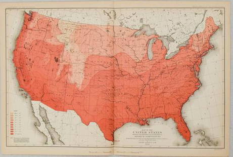
Sold20211880 Gannett Climate Map of the US with IsothermalTitle: 1880 Gannett Climate Map of the US with Isothermal Minimum Temperature Lines -- Map of the United states Showing the Distribution of Lines of Minimum Temperature… Cartographer: H Gannett / DeSee Sold Price
Sold2023Gross, Alexander 1920 Lot of 11 Large Maps. AmericasIncl Maritime Provinces and Quebec, United States and Mexico, Mexico, USA - South West, USA - South-Central, South America - South East, USA - Climate, South America - North East, South America NorthSee Sold Price
Sold2018Map of Western States Of United States 1861 JohnstonVery beautiful map of Western States of United States Author: Johnston, Alexander Keith (1804-1871) Atlas: The royal atlas of modern geography, exhibiting, in a series of entirely original.... Date: 1See Sold Price
Sold20162 United States Maps, including 1817.2 United States Maps, including 1817. 1st item: Northern Provinces of the United States map by John Thomson from "Thomson's New General Atlas", engraved by Nathaniel Rodgers Hewitt, 1817. Colored mapSee Sold Price
Sold2023Large Collection of Vintage United States MapsAntique maps of the United States. Approximately 100 pieces. As is, as shown. Provenance: Phyllis Lucas Gallery, NYC.See Sold Price
Sold2017Stackhouse: Earliest Independent United States Map 1783Item: Earliest Independent United States Map Maker: Thomas Stackhouse Date: 1783 Measures 16" x 20 1/4" Map fully within boarder. Margin uneven on left side. Strong printing, plate mark easily visibleSee Sold Price
Sold2022Map of United States, JH Colton, ca 1849A framed map of the United States, Map of the United States of America, The British Provinces, Mexico, the West Indies and Central America with part of New Granada and Venezuela by JH Colton, ca 1849,See Sold Price
Sold2022Pair PAUL McCOBB Side Table with Hairpin Iron Bases. RePair PAUL McCOBB Side Table with Hairpin Iron Bases. Redone with United States Map Tops. Dimensions: H: 19.5 inches: W: 18 inches: D: 24 inches ---See Sold Price
Sold2020Early United States Roll-Up MapEarly United States roll-up map. Published by J. H. Colton / New York / 1853. 44 1/2" x 36".See Sold Price
Sold2023BEMIS, Waldo. Pictorial Fishing or Angling Map of the Unite...BEMIS, Waldo. Pictorial Fishing or Angling Map of the United States. 1941. Map depicts the Continental U.S. and illustrates the distribution of warm and cold-water fish throughout the country, courtesSee Sold Price
Sold20181876 Colton Folding Map of the Western United States --Title/Content of Map: 1876 Colton Folding Map of the Western United States -- Colton's Map of the States and Territories West of the Mississippi River to the Pacific Ocean Showing the Overland Routes,See Sold Price
Sold2019Williams Map of America (1833)WILLIAMS, C.S. (Fl. 1830-1846). Traveler's Directory and Statistical view of the United States and Map of the U.S. Engraved folding map in original gilt red boards. New Haven, 1833. 5 1"8" x 3 1/8" coSee Sold Price
Sold2018Southern provinces of the United States. THOMSON. WestTITLE/CONTENT OF MAP: 'Southern provinces of the United States' The map shows the United States including the first 17 states to acceed, including Tennessee, which had joined in 1796. Ohio, LouisianaSee Sold Price
Sold2020"Northern provinces of the United States". THOMSON.TITLE/CONTENT OF MAP: 'Northern provinces of the United States' The map shows the "District of Maine", prior to its accession to the Union as the state of Maine in 1820. The top image on the right hanSee Sold Price
Sold2023Southern provinces of the United States. THOMSON. West & East Florida 1830 mapTITLE/CONTENT OF MAP: 'Southern provinces of the United States' The map shows the United States including the first 17 states to acceed, including "Tenasee" (Tennessee), which had joined in 1796. OhioSee Sold Price
Sold2023Southern provinces of the United States. THOMSON. West & East Florida 1817 mapTITLE/CONTENT OF MAP: 'Southern provinces of the United States' The map shows the United States including the first 17 states to acceed, including Tennessee, which had joined in 1796. Ohio, LouisianaSee Sold Price
Sold2023Northern provinces of the United States. THOMSON. District of Main[e] 1817 mapTITLE/CONTENT OF MAP: 'Northern provinces of the United States' The map shows the "District of Maine", prior to its accession to the Union as the state of Maine in 1820. Some Native American Indian viSee Sold Price
Sold20211832 Mitchell Map of the United States -- Mitchell'sTitle: 1832 Mitchell Map of the United States -- Mitchell's Travellers Guide Through the United States. A Map of the Roads, Distances, Steam Boat & Canal Routes & c. by J.H. Young Cartographer: S MitcSee Sold Price
Featured6 days LeftJasper52Rand, McNally & Co.'S New Commercial Railroad Map of the United States [Chicago to Denver]$25
Featured6 days LeftJasper52Railroad Map of the United States Showing the Through Lines of Communication...$50
Featured6 days LeftJasper52Johnson's New Military Map of the United States Showing the Forts, Military Posts &C. With Enlarged$65
21 hrs LeftPotter & Potter Auctions[PICTORIAL MAPS – TRAVEL]. Three Pictorial Maps. 1940s/50s....$150
6 days LeftHess Fine Auctions1885 A Popular History Of The United States JC Ridpath Gilt Green Leather Book Illustrated$10
Jun 12Dan Morphy AuctionsPHELPS’S TRAVELERS GUIDE THROUGH THE UNITED STATES; CONTAINING UPWARDS OF SEVEN HUNDRED$1,000
2 days LeftAlbion AuctionsBlackie (Pub) 1882 Pair of Maps. USA - Atlantic States & Mississippi Valley$5
3 days LeftTrillium Antique Prints & Rare BooksWilson - Brant, Scoter Duck, Velvet Duck, Harlequin Duck, Dusky Duck, Marsh Tern, Sooty Tern. 72$75
Jun 05Lion Heart AutographsEx-Pres. Pierce Plans to Overthrow US Government! Fake News and the Notorious Hopkins Hoax of 1862$500
3 days LeftTrillium Antique Prints & Rare BooksWilson - Louisiana Heron, Hooping Crane, Long-billed Curlew, & Pied Oyster-catcher. 64$75
3 days LeftTrillium Antique Prints & Rare BooksHolbrook - Pair of Frog or Toad Lithographspair - Frog or Toad$50


![Johnston Map of U.S. 1844: *** START PRICE IS THE RESERVE *** [America] JOHNSTON, Alexander Keith (1804-1871). United States and Texas. Lithograph with original color. London, 1844. 21 1/8" x 26 1/8" sheet. Comparable: Old Worl](https://p1.liveauctioneers.com/1968/163248/82424588_1_x.jpg?height=310&quality=70&version=1583340284)
![Johnston Map of U.S. 1875: *** START PRICE IS THE RESERVE *** [America] JOHNSTON, Keith (1804-1871) United States of North America (Western States) Lithograph. Edinburgh, 1875. 19 1/4" x 24 1/4" sheet. Comparable: Old World Auc](https://p1.liveauctioneers.com/1968/163248/82424586_1_x.jpg?height=310&quality=70&version=1583340284)


![Northern provinces of the United States. THOMSON. District of Main[e] 1817 map: TITLE/CONTENT OF MAP: 'Northern provinces of the United States' The map shows the "District of Maine", prior to its accession to the Union as the state of Maine in 1820. Some Native American Indian vi](https://p1.liveauctioneers.com/5584/309982/165835410_1_x.jpg?height=310&quality=70&version=1700599538)


![Rand, McNally & Co.'S New Commercial Railroad Map of the United States [Chicago to Denver] (1 of 1)](https://p1.liveauctioneers.com/5584/329422/177662153_1_x.jpg?height=282&quality=70&version=1715717898)


![[PICTORIAL MAPS – TRAVEL]. Three Pictorial Maps. 1940s/50s.... (1 of 4)](https://p1.liveauctioneers.com/928/325952/175495561_1_x.jpg?height=282&quality=70&version=1712935174)


