Sold2022Vintage Map of Wyoming Sgd. Grace Raymond Hebard.A Vintage illustrated map called "History and Romance of Wyoming", by Grace Raymond Hebard and Paul M Paine. It is Signed lower right, "Grace Raymond Hebard". The Map is in excellent condition, and meSee Sold Price
Sold2020The Bozeman Trail by Hebard and Brininstool (2V)The Bozeman Trail by Grace Raymond Hebard and E. A. Brininstool. Two volume set. 1922. The Arthur H. Clark Co., Clevland.346 pp. plus 306 pp. with fold out maps and many illustrations. Red cloth withSee Sold Price
Sold2021Sacajawea Guide of Lewis and Clark 1957Sacajawea , A guide and interpreter of the Lewis and Clark expedition by Grace Raymond Hebard. 1957 The Arthur H. Clark Co., Glendale, California. 340 pp. Illustrated. Measures 9.25 in. x 6.25 in. x 1See Sold Price
Sold2021The Bozeman Trail by Hebard and Brininstool 1960The Bozeman Trail by Grace Raymond Hebard and E. A. Brininstool. Two volumes in one. 1960. The Arthur H. Clark Co., Glendale, California. Illustrated. Cloth covers with gilt lettering. Measures 9.5 inSee Sold Price
Sold2022The Bozeman Trail, Jim Bridger, etc., 5 works in 6 vols.Hebard, Grace Raymond, and E. A. Brininstool. The Bozeman trail. Cleveland: The Arthur H. Clark Co., 1922. Howes H-382. 2 vols. Very good in orig. cloth. Autograph ownership inscriptions “WilliaSee Sold Price
Sold2022Vintage map of North America, Johnson/Ward, 1865Dynamic map of the North American continent with Dakota still a complete territory (Wyoming still part of Dakota). Nevada, Utah, Arizona still with unsettled borders and Oklahoma remains Indian TerritSee Sold Price
Sold2022Vintage (12) Maps of EgyptTwelve (12) vintage maps of Egypt. Measure approximately from 19 in. x 24 in. to 25 in. x 35 in. with seven (7) linen backed. Rolled. Provenance: William Emery Collection, Sheridan Wyoming. If lot isSee Sold Price
Sold2021(7) 1980s Burlington Northern State Railroad MapsGreat lot of vintage maps from Burlington Northern. Each come with original sleeve and original envelope mailer. Oregon/California, Washington/Idaho, Illinois, Wyoming, North Dakota, Nebraska/Kansas aSee Sold Price
Sold2022Western Historic Maps (5) [153132]Five vintage travel maps of Idaho, Montana, New Mexico, Utah, and Wyoming. Compliments of Continental Oil. Co., Denver, Colorado. Each map is approx. 24 x 21 inches when unfolded. Good condition, theSee Sold Price
Sold2018Group of vintage assorted postcardsTogether with Grace Line poster, 2 Sotheby's automobile posters, Return of Jedi Poster, Map of Howell Works and two art works.See Sold Price
Sold2016Rare Vintage Map of Afghanistan War Rug: 5'9'' x 7'3''Rare Vintage Afghanistan War Rug showing map of world with Afghanistan at its center from refugee camp in Peshawar, Pakistan. 1997. Size: 5'9'' x 7'3'' (175 x 221 cm). An outstanding and large exampleSee Sold Price
Sold2022Abraham Orthelius, Americae Sive Novi, Vintage MapABRAHAM ORTELIUS (Belgian, 1527- 1598), Americae Sive Novi Orbis Nova Descriptio, 1602, vintage copper engraved map with hand-coloring, possibly later print, image: 15.5 x 19 inches, framed: 20 x 24.5See Sold Price
Sold2017Vintage Map, A Perfect Description of the NorthernmostVintage Map, "A Perfect Description of the Northernmost Coastes of England..." engraving with hand-coloring with text verso, overall (with frame): 13.5"h x 21"wSee Sold Price
Sold2015Vintage Map, Jodocus Hondius, Virginae item etJodocus Hondius (Dutch, 1563-1612), "Virginiae item et Floridae," copper engraved map with hand-coloring, map: 13.25"h x 19"w, overall (with frame): 16.5"h x 21.75"wSee Sold Price
Sold2022Petrus Kaerius and Abraham Ortelius, Two Vintage MapsPETRUS KAERIUS and ABRAHAM ORTELIUS (Flemish, 1571-1646), and (Belgian, 1527-1598), Orbis Terrarum Typus De Integro Multis In Locis Emendatus auctore Petro Kaerio anno 1607, and Indiae Orientalis InsuSee Sold Price
Sold2022Abraham Ortelius and Theodore de Bry, Two Vintage MapsABRAHAM ORTELIUS and THEODORE DE BRY (Belgian, 1527-1598), (German, 1528 - 1598), Maris Pacifici quod vulgo Mar del Zud, 1601, and Hispaniae Novae Sive Magnae, Recens et Vera Descriptio, 1595, two vinSee Sold Price
Sold2022Abraham Ortelius and Jacob Van Meurs, Two Vintage MapsABRAHAM ORTELIUS and JACOBUS VAN MEURS (Belgian, 1527-1598), (Dutch, 1760-1824), Tartariae Sive Magni Chami Regni typus, circa 1609 AND Novissima et Accuratissima Totius Americae Descriptio per JacobuSee Sold Price
Sold2022Vintage Maps of Texas CountiesBound vintage book containing maps of Texas counties, featuring maps based off early twentieth century cartography 1.5"h x 17"w x 14"d We happily provide seamless shipping services on everything weSee Sold Price
Sold2021c1960 EB Map Vender Model No. 4DR w/ 54 Maps Coin-OPVery nice vintage map coin-op vending machine by EB Map Vender, Model No. 4DR. Comes filled with 54 vintage maps from the 1930s to 1970s. Maps in front show the progression of the company from RichfieSee Sold Price
Sold2022Exact Chart of the River St. Laurence, Thomas Jeffreys c1775Historically important chart published during the American Revolutionary War. An incredibly impressive and large vintage map in immaculate condition. Contains geographical and navigational data alongSee Sold Price
Sold2023Framed Map of Fort Worth StockyardsVintage map of the U.S. Department of Agriculture's 1937 master plan for the Fort Worth Stockyards, framed sight: 22 x 30 in., frame: 33 x 45 in. Provenance: The Dallas, Texas collection of a lSee Sold Price
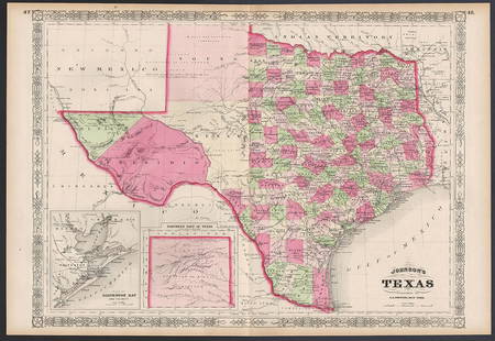
Sold2023Excellent example of Johnson’s Texas, 1866Authentic and impressive vintage map of Texas. One of the more collectible maps to be produced in the mid-19th century. A highly desirable map that details the state in full. Shows the elevated TableSee Sold Price
Sold20241775-1780 Upper Midwest and Great Lakes region. By Bonne & RaynalTitle: 1775-1780 Upper Midwest and Great Lakes region. By Bonne & Raynal Date/Period: 1775-1780 Materials: Copperplate engraved Size: 14 1/2” x 9 1/2 “ This vintage map, created by R. BonnSee Sold Price
Sold2023Collection of Maps on North & South AmericasA collection of vintage maps of North and South Americas, some old, some newer, some color, hand colored, and black and white, including Manhattan, United States, South America, and some Caribbean IslSee Sold Price
4 days LeftAntiques Online AuctionsVintage Texas 1845 Map Printed in 1986, Compiled by John Davis$60(4 bids)
Jun 07Ray's Premier AuctionLot of 3 -Rabbit Oil Paintings on Panel by Robert Grace and Lyndi$55(2 bids)
Jun 12The Benefit Shop Foundation Inc.COSANTI ARCOSANTI PAOLO SOLERI Sgd Cast Bronze Chime$225(10 bids)
6 days LeftNorthgate Gallery, Inc.Vintage Baker Furniture George II Style Wing Back Arm Chairs, Pair$200
Jun 23Schilb Antiquarian Rare Books1877 Geology Geography Surveys 1ed Nevada Wyoming Utah George Wheeler US West 2v$1


![Western Historic Maps (5) [153132]: Five vintage travel maps of Idaho, Montana, New Mexico, Utah, and Wyoming. Compliments of Continental Oil. Co., Denver, Colorado. Each map is approx. 24 x 21 inches when unfolded. Good condition, the](https://p1.liveauctioneers.com/2699/258185/134287893_1_x.jpg?height=310&quality=70&version=1660347389)