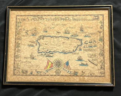
Sold2023Vintage Hand -Colored Pictorial Map of Puerto Rico Circa 1931 by E.B.K. DooleyA vintage hand-colored map of Puerto Rico by E.B.K. Dooley, published c. 1931. This map has a decorative border filled with local plants, wildlife, buildings and transportation. In small scrolls, therSee Sold Price
Sold2022EBK Dooley Hand Colored Puerto Rico Pictorial MapAntique hand colored map of Puerto Rico by EBK Dooley (Eliza Bellows King Dooley), published 1931. No tares and color it still vibrant.See Sold Price
Sold2021Antique MapsGrouping of Two (2) Antique Engraved Maps. Includes a J.H. Colton & Co hand colored map of Cuba, Jamaica, and Puerto Rico together with a Jacques-Nicolas Bellin "Carte de la Nouvelle Angleterre, NouveSee Sold Price
Sold2021(16) 19TH C. MAPS OF THE WEST INDIES IN FOLIO,Including: "L'Isle de Ste. Domingue, et celle de Porto Rico", by Bonne, hand colored engraving,1778, 10" x 14 1/2"; PLUS "West Indies", Smith's Atlas, 1808, hand colored engraving, 1808, 11" x 14"; PLSee Sold Price
Sold2020Illustrated Van Loon Hand-Colored World Map, 1932Hendrik Willem Van Loon (Dutch-American, 1882-1944). Illustrated World Map, 1932. A hand colored outlined pictorial map of the world on Mercator projections with topographical relief shown pictoriallySee Sold Price
Sold20191750 Handcolored Map BrabantCirca 1750 hand colored map “Hartogdom Braband”, Fine condition, measures 11.625 x 8.125”. Reserve: $20.00 Shipping: Domestic: Flat-rate of $5.00 to anywhere within the contiguous U.S. InternatiSee Sold Price
Sold20181773 Hand Colored Bellin Map of MexicoHandcolored map of Mexico by Jacques Bellin, circa 1773, printed at Amsterdam. Fine condition, measures 16.5 x 10.5”. Please note that this lot has a confidential reserve. When you leave a bid in adSee Sold Price
Sold2024Gerard Mercator (Belgian 1512 - 1594) and Rumold Mercator (Belgian 1545 - 1599)Gerard Mercator (Belgian 1512 - 1594) and Rumold Mercator (Belgian 1545 - 1599) "Orbis Terrae Compendiosa Descriptio", circa 1595 Engraved and hand colored map 14 1/2" x 19 3/4" Condition: aging, yellSee Sold Price
Sold2020Small Hand-Colored Map of Nantucket by William SchontzeSmall Hand-Colored Map of Nantucket by William Schontzeler,rare pictorial map of Nantucket in original frame, signed, l.r William Cotton Schontzeler, trained as a draftsman in NY, he owned and workedSee Sold Price
Sold2024Johann Homann Hand-Colored Map Engraving, c. 1730Johann Baptist Homann (German, 1664-1724), Generalis Totius Imperii Russorum, Hand-Colored Engraving, printed circa 1730, painted red frame. Image: 20" H x 23" W; frame: 27" H x 33" W. Provenance: ProSee Sold Price
Sold2020Scarce hand-colored map of Texas, 1875Attractive and scarce map of Texas with inset map "Western Part of Texas". Exquisite detail with counties painstakingly colored by hand. Interesting map of the growing state developed circa 1875 durinSee Sold Price
Sold2019Hand-Colored Map of North America, 18th c."Carte du Continent de L'Amerique Nord." Circa late 18th c. On laid, sheet 14" x 11.5". Hand-colored, a couple of small marginal tears and light marginal chipping, the whole with some creases (as prevSee Sold Price
Sold20191760 Hand Colored Map of Panama TirionFine engraved handcolored map of Panama entitled “Kaart van de Landengte van Panama”, by Isaak Tirion at Amsterdam circa 1760. Measures 17 x 16”. Reserve: $20.00 Shipping: Domestic: Flat-rate ofSee Sold Price
Sold2022TWO HAND-COLORED MAPS OF THE EAST INDIESTWO HAND-COLORED MAPS OF THE EAST INDIES1) “Carte des Isles de Java, Sumatra, Borneo & Les Detroits de la Sonde Malaca et Banca Golphe de Siam …”, Jacques Bellin, Paris, circa 1762.See Sold Price
Sold2022DES BARRES, JOSEPH FREDERICK WALLET The North East Shore of the Gulph of Mexico. London: circa 1780.DES BARRES, JOSEPH FREDERICK WALLET The North East Shore of the Gulph of Mexico. London: circa 1780. A very large hand-colored engraved map on four joined sheets. Overall 30 x 84 inches (76 x 214 cm).See Sold Price
Sold2016Atlas of Europe in German, Hand-Colored - Circa 1840Atlas of 28 detailed maps of various countries in Europe. Published in Leipzig by Schreibers Erben. All maps are impressively hand-colored. On some of the maps there are handwritten notes and a signatSee Sold Price
Sold2024Angel Botello 'Juan' Original Oil Painting 1965Angel Botello Barros, Puerto Rico (1913-1986). 'Juan', circa 1965. Oil on board with original hand carved frame. Signed lower right and numbered 824 on verso. Measures 35.5"H x 29"W framed; 24"H x 18"See Sold Price
Sold2022ANDY WARHOL (1928-1987) AMERICANOriginal Serigraph with hand water coloring on paper "Flowers Unique" (Hand colored). Circa 1974. Publisher: Peter M. Brant, Castelli Graphics and Multiples, Inc. Limited Edition of 250. Hand InitialeSee Sold Price
Sold2024Revolutionary Era War Map of the Attack on Ft. Moultrie.Original 18th C hand colored map dated June 28th 1776 appears to be a fold out from a publication of the situation and stations of the British Vessels under the command of Sir Peter Parker upon the atSee Sold Price
Sold2016A Map of the United States & MexicoHenry Tanner (1786-1858). New York: Tanner, 1850. Hand-colored Pocket Map. 23 x 29 inches visible, 38 x 39 1/2 inches framed.See Sold Price
Sold2022(REPUBLIC OF TEXAS.) James Hamilton Young. A New Map of Texas, with the Contiguous American &(REPUBLIC OF TEXAS.) James Hamilton Young. A New Map of Texas, with the Contiguous American & Mexican States. Hand-colored engraved map of Texas with inset text panels relating information on its riveSee Sold Price
Sold2023RARE BUCHOLTZ-LUDWIG ANTEBELLUM POCKET MAP OF VIRGINIARARE BUCHOLTZ-LUDWIG ANTEBELLUM POCKET MAP OF VIRGINIA, hand-colored lithograph, Map of the State of Virginia Containing the Counties, Principal Towns, Railroads, Rivers, Canals & All Other Internal ISee Sold Price
Sold2022(MEXICO.) Henry Schenk Tanner. A Map of the United States of Mexico,(MEXICO.) Henry Schenk Tanner. A Map of the United States of Mexico, As Organized and Defined by the Several Acts of Congress of that Republic. Large hand-colored lithographed map of southwestern NortSee Sold Price
2022Blaeu, Johannes (Netherlands, 1596-1673) "The New World Map" Double Hemisphere World Map C. 1664Nova et Accuratissima Totius Terrarum Orbis Tabula Translated "The New World Map", Hand Colored w/ Elaborately Decorated Spandrels.   Sight View 16" x 21-1/2", Overall View 21" x 25-1/2"See Sold Price