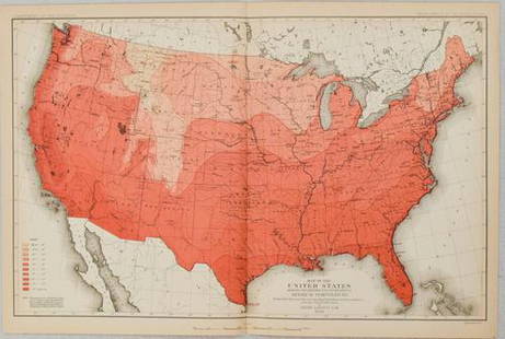
Sold2019Map of Predominating Sex Showing the Local Excess ofTitle: Map of Predominating Sex Showing the Local Excess of Males Or Of Females in the Distribution Of Population Over The Territory Of The United States East Of The 100th Meridian. Publication Date:See Sold Price
Sold2022United States population progression 1790,1800,1810, 1820, four in one map, by Francis WalkerTitle: United States population progression 1790,1800,1810, 1820, four in one map, by Francis Walker Date/Period: 1874 Materials: Color Lithographie printing Size: 17x21" First Statistical atlas of thSee Sold Price
Sold2022United States population by race and state 1870. (1874)Title: United States population by race and state 1870. (1874) by Francis Walker Date/Period: 1874 Materials: Color Lithographie printing Size: 17x21" 1874, First Statistical atlas of the US, by FraneSee Sold Price
Sold2020United States Population Map 1900Title/Content of Map: United States Population Map 1900 Date Printed: 1900 Material/Medium: Paper Size: approx 21.14 inches Additional Info: Rand McNally prepared for The Public Ledger, Philadelphia RSee Sold Price
Sold2022United States population progression 1790,1800,1810, 1820, four in one map, by Francis WalkerTitle: United States population progression 1790,1800,1810, 1820, four in one map, by Francis Walker Date/Period: 1874 Materials: Color Lithographie printing Size: 17x21" First Statistical atlas of thSee Sold Price
Sold2022United States population by native & foreign born. 1874. By Francis Walker.Title: United States population by native & foreign born. 1874. By Francis Walker. Date/Period: 1874 Materials: Color Lithographie printing Size: 17x21" 1874, First Statistical atlas of the US, by FraSee Sold Price
Sold2024Nicole Miller Limited Ed Silk Shirt, c.1991 USASize Medium Nicole Miller Shirt sleeve silk blouse. Whimsical horticulture / garden design exclusively made for the United States population. Limited edition pattern c. 1991. Looped green garden hoseSee Sold Price
Sold2022United States Wealth distribution 1870 (1874) byTitle: United States Wealth distribution 1870 (1874) by Francis Walker Date/Period: 1874 Materials: Color Lithographie printing Size: 17x21" 1874, First Statistical atlas of the US, by Franeis Walker,See Sold Price
Sold2022United States insane population by gender and race.Title: United States insane population by gender and race. 1874 by Francis Walker Date/Period: 1874 Materials: Color Lithographie printing Size: 17x21" 1874, First Statistical atlas of the US, by FranSee Sold Price
Sold2022United States blind population by gender and race. 1874Title: United States blind population by gender and race. 1874 by Francis Walker Date/Period: 1874 Materials: Color Lithographie printing Size: 17x21" 1874, First Statistical atlas of the US, by FraneSee Sold Price
Sold2016The United States: 1776-1846 At One View. New York: H.The United States: 1776-1846 At One View. New York: H. Phelps, 1846. Hand-colored lithograph of a variety of statistics related to the United States, including populations, canals, railroads, steam boSee Sold Price
Sold2023CHISHOLM HALL Chandelier by The Urban ElectricBeautiful chandelier designed and manufactured in the United States by The Urban Electric, dated 2012. The piece is from the Chisholm Hall collection. Measurements: 36 inches high to the top of theSee Sold Price
Sold2020Reconnoissance Map of the United States Showing theTitle: Reconnoissance Map of the United States Showing the Distribution of The Geologic System Cartographer: MC GEE, W. J. Date: 1893 Publisher: U.S. GEOLOGICAL SURVEY Size: 17.5Height - 28.25Width AdSee Sold Price
Sold20211880 Gannett Climate Map of the US with IsothermalTitle: 1880 Gannett Climate Map of the US with Isothermal Minimum Temperature Lines -- Map of the United states Showing the Distribution of Lines of Minimum Temperature… Cartographer: H Gannett / DeSee Sold Price
Sold20221900 US Government Map of US Urban PopulationTitle: 1900 US Government Map of US Urban Population Distribution -- Proportion of Population in Cities and Towns of More than 2000 Inhabitants at the Twelfth Census 1900 Cartographer: US Department oSee Sold Price
Sold20231880 US Census Map of Corn Production per Capita -- Map of the United States Showing theTitle: 1880 US Census Map of Corn Production per Capita -- Map of the United States Showing the Distribution of Production of Indian Corn in Bushels per Capita… Cartographer: US Census Bureau YeSee Sold Price
Sold20231880 US Census Map of Wheat Production per Capita -- Map of the United States Showing theTitle: 1880 US Census Map of Wheat Production per Capita -- Map of the United States Showing the Distribution of Production of Wheat in Bushels per Capita… Cartographer: US Census Bureau Year /See Sold Price
Sold20231880 US Census Map of Oats Production per Capita -- Map of the United States Showing theTitle: 1880 US Census Map of Oats Production per Capita -- Map of the United States Showing the Distribution of Production of Oats in Bushels per Capita… Cartographer: US Census Bureau Year / PlSee Sold Price
Sold2016United States Map, Density of Population, 1895Original engraving from Atlas of the World by Rand McNally, 1895. Map includes counties, geographical landmarks, streets and population data. Dimensions: 21 1/4" x 14" No Reserve Buyer pays shipping -See Sold Price
Sold2022United States People of color distribution 1870, (1874)Title: United States People of color distribution 1870, (1874) by Francis Walker Date/Period: 1874 Materials: Color Lithographie printing Size: 17x21" 1874, First Statistical atlas of the US, by FraneSee Sold Price
Sold2017Map of the United States showing Density of PopulationRand, McNally & Co. 1898 New Standard Atlas of the World. Also contains census information on population 1870, 1880, and 1890 Size: 21 x 15 inches No Reserve: This lot starts at $1 and has no reserveSee Sold Price
Sold2022United States deaf and mute population by state. 1874Title: United States deaf and mute population by state. 1874 by Francis Walker Date/Period: 1874 Materials: Color Lithographie printing Size: 17x21" 1874, First Statistical atlas of the US, by FraneisSee Sold Price
Sold2022United States deaf and mute population by gender andTitle: United States deaf and mute population by gender and race. 1874 by Francis Walker Date/Period: 1874 Materials: Color Lithographie printing Size: 17x21" 1874, First Statistical atlas of the US,See Sold Price
Sold20241884-S-NGC Morgan Silver Dollar XF 45The 1884 S Morgan Dollar went into circulation in the western parts of the United States. Because of this distribution very few issues of this date and mint mark exist in Uncirculated or lightly circuSee Sold Price
Jun 12Dan Morphy AuctionsPLATE CXIII. MAP OF INDIAN TERRITORY SHOWING DISTRIBUTION OF WOODLAND” FROM THE TWENTY-FIRST$100
Jun 20The Ross Art GroupOriginal World War ll 1943 Poster - Back the Attack by George Schreiber - Medium Size$450
Jun 20The Ross Art GroupOriginal Vintage WWI Poster Save a Loaf a Week Help Win the War by Cooper 1917 USFA$200
18 hrs LeftThe Magnusson Group1990-W United States 4 Proof Gold Eagle Coin Set in Packaging$3,800(7 bids)