Sold2020Three Historic Maps: New Map of Europe from TheThree Historic Maps: New Map of Europe from The Latest Authorities, 1811, Delaware from the Belt Authorities, 1796, North Carolina published by J.H. Colton Co., largest 19 x 21 inSee Sold Price
Sold20181856 Cruchley Map of Europe with Early Railroads ShownTitle/Content of Map: 1856 Cruchley Map of Europe with Early Railroads Shown -- A New Map of Europe Exhibiting its Natural & Political Divisions Drawn from the Most Recent Authorities Improved to theSee Sold Price
Sold2021ANTIQUE ENGRAVING ON PAPER, H 15", W 20", NEW MAP OFANTIQUE ENGRAVING ON PAPER, H 15", W 20", NEW MAP OF EUROPE An antique engraving on paper titled "A New Map Of Europe," dedicated to William Duke of Gloucester. Frame measures H 23" x L 28".See Sold Price
Sold2023Early 19th Century Map Engravings of Europe by William Darton (1755-1819)New Map of Europe & A New Map of France Divided into its Departments 2 engravings on paper William Darton (1755-1819) 11.75 x 9.5 (plate) 15.5 x 12.25 inches (paper) (unframed) William Darton (175See Sold Price
Sold2017Bowen: Antique Map of Europe, 1778Map: A New & Accurate Map of Europe, Publication Date: 1778 Authors: BOWEN, THOS. Size: Quarto – 12.80 H x 16.75 W Inches drawn from the best authorities, by Thos. Bowen. 1777Engraved for Middleton'See Sold Price
Sold2024Vintage Reproduction of Historic 1777 Map of New JerseyVintage Reproduction of Historic 1777 Map of New Jersey, approximate size, 31.5"H x 20"WSee Sold Price
Sold20211721 Map of America With California as an IslandHistoric Maps 1721 Hand-Colored "A New Map of America from the Latest Observations" with "California" Shown as an Island 1721 Hand-Colored Engraved Western Hemisphere Map titled, "A New Map of AmericaSee Sold Price
Sold2021Rollos & Vaugondy 1765 Map of Europe"A New & Accurate Map of Europe" Copper Engraved Map Published 1764-66, London for "A New History of England..." by Thomas Mortimer. Maps Engraved by George Rollos after Robert de Vaugondy. Paper SizeSee Sold Price
Sold2023A Grouping of 17th & 18th Century Old World Maps Lot of 6Lot Includes: The English Channel, A Map of France, North American Rivers and Lakes Between Superior and Slave Lake (2), A New map of Russia in Europe, & Nouvelle Carte Du Royaume de Bengale EngraSee Sold Price
Sold2020Fenning & Collyer 1765 Antique Map of Europe"A New & Accurate Map of Europe" Copper Engraved Map Published 1764-65, London for "A New System of Geography: or, A General Description of the World" by Daniel Fenning & Joseph Collyer. Maps by G. RoSee Sold Price
Sold20231784 Detailed Map of Turkey in EuropeA New Map of Turkey in Europe, published by Harrison and Co., London 1784. Very Good, light offset, folds as issued, measures 10 x 16". Reserve: $20.00 Shipping: Domestic: Flat-rate of $6.00 to anywheSee Sold Price
Sold2022From the London Magazine, Three 18th Century Maps: A New Chart of the Rover St. Lawrence from theFrom the London Magazine, Three 18th Century Maps: A New Chart of the Rover St. Lawrence from the Island of Anticosti...; A Plan of the River St. Lawrence from the Falls of Montmorenci to Sillery...;See Sold Price
Sold20231862 Civil War, Coltons New Topographical Map of The States of Virginia, Maryland and DelawareHistoric Maps 1862 Civil War "Colton's New Topographical Map of The States of Virginia, Maryland and Delaware" Hardcover Folio 1862-Dated Civil War Period, Hand-colored 45.25" x 31.5" Folding Map titlSee Sold Price
Sold20203 Maps Including Russia, Europe, and GermanyIncludes Russia in Europe, Map of Europe, and A New Map of Germany, Thomas Cowperthwait & Co., 1850.See Sold Price
Sold2019Europe.- Moll (Herman) A New Map of Germany, Hungary,Europe.- Moll (Herman) A New Map of Germany, Hungary, Transilvania & the Suisse Cantons, showing from the North Sea east to Danzig, Belgrade and Trieste incorporating all of Germany, Switzerland, AustSee Sold Price
Sold20183 Maps incl: Map Of Boston And Adjacent Cities.[World/ Massachusetts/Europe] 3 Maps. ++ A New Map Of The World On The Globular Projection. Phila: Thomas, Cowperthwait & Co., (1850). Hemispheres. Outer edge of overall border: 9 1/2 x 14 1/8 in. TonSee Sold Price
Sold2020Colored Engraving, Map of Europe, Eman BowerA New and Accurate Map of Europe, Eman Bower circa 1760, colored engraving. Custom burlwood frames by Giovanni Baccani, Florence, 15" x 18" unframed, 23" x 26" framed. Provenance: John's Island, VeroSee Sold Price
Sold20191782 New Map of the World Navigation Routes“A New Map of the World in Three Sections wherein the several tracks and discoveries of the British Navigators to the present time are distinctly and accurately laid down”, by J. Bayly, printed atSee Sold Price
Sold2024Antique Map of Europe - Iceland - Emanuel Bowen - Scandinavia"A New and Accurate Map of Europe Drawn From the best Authorities". Detailed English map of Europe and Iceland by Emanuel Bowen. Emanuel Bowen (1694?-1767) was a British engraver and print seller. HeSee Sold Price
Sold2023Bowen, Thomas 1789 Large Map. Europe"A New and Accurate Map of Europe" Copper Engraved Map Published 1789-91 by C. Cooke, London for "The New Royal Encyclopedia, Or, Complete Modern Universal Dictionary of Arts and Sciences..." by WilliSee Sold Price
Sold2016Three maps of AsiaHeading: (Asia) Author: Title: Three maps of Asia Place Published: Various places Publisher: Date Published: Various dates Description: Includes:See Sold Price
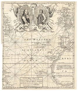
Sold20171740 Ornate Copperplate Engraved Portrait MapHistoric Maps 1740 Ornate Copperplate Engraved Map with Portraits of British Admirals “Robert Blake” & “Edward Vernon, Esq.” 1740-Dated, Copperplate Engraved Map titled “A New Map or Chart oSee Sold Price
Sold2022Six 19th Century Maps of North and South Carolinasix maps, engravings on wove paper, some with hand colored highlights, all unframed, including: three examples of Frank Gray, Gray's New Map of North and South Carolina, Philadelphia, circa 1881; JohnSee Sold Price
Jun 08Early American History Auctions1776 Map, PARTIE ORIENTALE DU CANADA, AVEC LA NOUVELLE ANGLETERRE, L'ACADIE... by P. Santini, Framed$950
Jun 08Early American History Auctions1836 Hand-Colored Map, Country Twenty Five Miles Round The City Of New-York Published by D.S. Stone$260
Jun 08Early American History Auctions1853 Map of Portion of British North America and Gulf of St. Lawrence, by Henry Perley$260
Featured4 days LeftJasper52Johnson's Venezuela, New Granada, Ecuador, Peru, Bolivia, Chile, Guiana 1861 map$85
Featured4 days LeftJasper52Venezuela, New Granada & Ecuador by J.W. Lowry. Colombia 1860 old antique map$40
Featured4 days LeftJasper52South America. New Granada & Venezuela. Colombia Panama. SWANSTON 1860 old map$50
Jun 02Gold Coast Auctioneers17th-19th c. French Wall Art Collection Map City Sea Scapes Scenes etc.$50
5 days LeftNY Elizabeth ANTIQUE MAP-ILLUSTRATED FLORAL ILLUSTRATION 1761 NEW DICTIONARY OF TRADE AND COMMERCE R. ROTH$50
1818 AuctioneersAmericana. Fagg, Helen & Eames, Wilberforce - Adventures in Americana 1492-1897. New York: Cooper£12(2 bids)
7 days LeftTrillium Antique Prints & Rare BooksWilkes - 6 View Engravings of New Zealand, Tonga, Fiji, &c.$100
7 days LeftTrillium Antique Prints & Rare BooksWilkes - 13 Native People Engravings (Portrait of Commanders including Wilkes, people from New$100
Jun 08Early American History AuctionsLot of Miscellaneous Printed Articles and Reproduction Souvenier Continental Army USA Design Buttons$100


![3 Maps incl: Map Of Boston And Adjacent Cities.: [World/ Massachusetts/Europe] 3 Maps. ++ A New Map Of The World On The Globular Projection. Phila: Thomas, Cowperthwait & Co., (1850). Hemispheres. Outer edge of overall border: 9 1/2 x 14 1/8 in. Ton](https://p1.liveauctioneers.com/179/117971/60557739_1_x.jpg?height=310&quality=70&version=1520636872)


![[Geneva Bible] (1 of 1)](https://p1.liveauctioneers.com/94/330664/178342142_1_x.jpg?height=282&quality=70&version=1716466933)


![[MAP]. ORTELIUS, Abraham. Romani Imperii Imago. 1592. (1 of 2)](https://p1.liveauctioneers.com/197/329395/177650537_1_x.jpg?height=282&quality=70&version=1715364962)


