Sold2022Tallest mountains and longest rivers. 1846 by A and C BlackTitle: Tallest mountains and longest rivers. 1846 by A and C Black Date/Period: 1846 Materials: Engraved Size: 12 x 17” Tallest mountains and longest rivers of the world. From ‘Blackâ€�See Sold Price
Sold20191850 Black's Illustration of World Mountains and RiversTitle/Content of Map: 1850 Black's Illustration of World Mountains and Rivers Cartographer: A & C BlackDate: 1850, London Size: 10 X 14.5 in. This is a very attractive map showing the world's longestSee Sold Price
Sold2018Cram: Antique Map of Tallest Mountains, Longest RiversTitle/Content of Map: 1886 Cram Map of Tallest Mountains and Longest Rivers -- Principal Mountains of the World and Principal Rivers of the World Date Printed: 1886, Chicago Cartographer: G Cram Size:See Sold Price
Sold20181892 Cram Map of Tallest Mountains and Longest RiversReserve Reduced! Title/Content of Map: 1892 Cram Map of Tallest Mountains and Longest Rivers -- Principal Mountains of the World and Principal Rivers of the World Date: 1892, Chicago Cartographer: G CSee Sold Price
Sold20181897 Cram Map of Tallest Mountains and Longest RiversTitle/Content of Map: 1897 Cram Map of Tallest Mountains and Longest Rivers -- Principal Mountains of the World and Principal Rivers of the World Date: 1897, Chicago Cartographer: G Cram Size: 11.3 xSee Sold Price
Sold20201854 BlackTitle/Content of Map: 1854 Black's Illustration of World Mountains and Rivers -- Physical Geography Cartographer: A & C Black Year/Place: 1854, Edinburgh Size: 10 X 14.5 in. This is a very attractiveSee Sold Price
Sold20211850 Black's Illustration of World Mountains and RiversTitle: 1850 Black's Illustration of World Mountains and Rivers -- [Physical Geography] Cartographer: A & C Black Year / Place: 1850, London Map Dimension (in.): 10 X 14.5 in. This is a very attractiveSee Sold Price
Sold20231882 Black World Map Plus Longest Rivers and Highest Moutains -- The WorldTitle: 1882 Black World Map Plus Longest Rivers and Highest Moutains -- The World Cartographer: A&C Black Year / Place: 1892, Edinburgh Map Dimension (in.): 16.5 X 20.3 in. This is a very interestingSee Sold Price
Sold20211846 Huge Carrington Map of Scotland -- A Map ofTitle: 1846 Huge Carrington Map of Scotland -- A Map of Scotland Divided into Counties Shewing The principal Roads, Railways, Rivers, Canals, Lochs, Mountains, Islands, &c. on a Scale of Five Miles toSee Sold Price
Sold2020Ansel Adams - San Francisco, California c.1953ANSEL ADAMS (B.1902-1984) San Francisco from San Bruno Mountain, California c.1953 Photo-Litho 11.5" x 15"See Sold Price
Sold2018Ethel Magafan (1916-1993)Mountain River, c. 1970, Oil on Board, 9" x 18 3/4", Signed Lower Right, Framed. Gonso Gallery, NYC on verso.See Sold Price
Sold2022Spain and Portugal 1846 by A & C BlackFrom ‘Black’s General Atlas’, by Adam and Charles Black. Engraved by Sidney Hall Edinburg. 21 1/2'' x 17''. Excellent condition. Authenticity Guaranteed. Reserve: $12.00 Shipping: DoSee Sold Price
Sold2020Edward Wells Map of South America ca. 1700-1738Edward Wells (1667–1727), engraved by Benjamin Cole, "A New Map of South America, Shewing it's General Divisions, Chief Cities & Towns; Rivers, Mountains & c," London, ca. 1700-1738. Hand colorSee Sold Price
Sold2022Edward Wells A New Map of South America, 1700Edward Wells (1667-1727), engraved by Benjamin Cole, "A New Map of South America Shewing its General Divisions, Chief Cities & Towns; Rivers, Mountains & c.", London, circa 1700, hand colored engravedSee Sold Price
Sold2015EARLY MAP - "A New Map of Iberia Europaea aliasEARLY MAP - "A New Map of Iberia Europaea alias Celtiberia or Ancient Spain. Shewing its Principal Divisions and Cheife Cities, Towns, Rivers, Mountains, &c. Dedicated to His Highness, William, Duke oSee Sold Price
Sold2020Edward Wells Map of Africa 1738Edward Wells (1667-1727), "A New Map of Africk Shewing its Present General Divisions Cheif Cities or Towns, Rivers, Mountains &c," London, ca. 1738. Hand colored map of Africa. With an elaborately decSee Sold Price
Sold2020Grp: Maps of Western EuropeLot of seven maps of Western Europe. Includes Edward Wells (1667–1727), "A New Map of Present Germany, Shewing Its Principal Divisions, Cities, Towns, Rivers, Mountains, &c. Dedicated to His HiSee Sold Price
Sold2021Wells map of South America c.1700Heading: Author: Wells, William Title: A New Map of South America, Shewing it's General Divisions, Chief Cities & Towns; Rivers, Mountains &c Place Published: London Publisher: Date Published: <See Sold Price
Sold2022American SchoolMid to late 19th century. Mountain river landscape signed C T Mitchell lower right. A nice long view up a river valley. Housed in a quality gilt frame. Framed: H15" W16 1/4" Sold from the collection oSee Sold Price
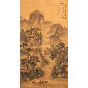
Sold2024Chinese School, scroll paintingChinese School, scroll painting, Chinese School (20th c.), Mountain river scene on silk, 49"h x 26.5"w (image), 76"h x 31"w (overall)See Sold Price
Sold2022Mexico, shows a independent Republic of Texas. Important S.W region map. 1846 by A and C BlackMexico with a independent Republic of Texas, shown at its largest territorial expanse. Although Texas would join the Union in 1845, this map was published in 1846 but was not updated in time making itSee Sold Price
Sold2022North America. Interesting S. W boundaries. 1846. By A and C BlackNorth America, massive Mexico still shows control of Texas and California, California is called ‘new’ and Baja California as ‘old’, the usual term of the era were ‘upper&See Sold Price
Sold2022Egypt. 1846 by A and C BlackTitle: Egypt. 1846 by A and C Black Date/Period: 1846 Materials: Engraved Size: 12 x 17” Egypt. From ‘Black’s General Atlas’, by Adam and Charles Black. Engraved by Sidney HallSee Sold Price
Sold2022Colombia, Peru with Ecuador and Venezuela. 1846 by A and C BlackColombia name is still over Ecuador and Venezuela but both countries are also shown independently. Shape of Peru is different. Bolivia still called ‘upper Peru’. 1846. From ‘BlackSee Sold Price
Jun 14Crescent City Auction GalleryThree Bark River Knives, 21st. c., Longest- L.- Blade- 4 1/2 in. (3 Pcs.)$325
Jun 14Crescent City Auction GalleryThree Bark River Limited Edition Knives, 21st c., Longest- L.- Blade- 5 in. (3 Pcs.)$250
Jun 14Crescent City Auction GalleryA Group of Three Pocket and Camp Knives, 21st c., L.- Longest- Blade- 4 1/2 in. (3 Pcs.)$425
Jun 14Crescent City Auction GalleryGroup of Six Knives, 20th c., Longest- L.- Blade- 5 1/2 in. (6 Pcs.)$425
Jun 14Crescent City Auction GalleryPair of Hunting Knives, 20th c., Longest- L.- Blade- 7 1/2 in. (2 Pcs.)$250
Jun 14Crescent City Auction GalleryThree Samurai Swords, 21st c., Longest- L.- 30 in.; Shortest- L.- 28 in. (3 Pcs.)$500
Jun 14Crescent City Auction GalleryA Group of Three Limited Edition Knives, 21st c., L.- Longest- Blade- 4 1/2 in. (3 Pcs.)$325
Jun 14Crescent City Auction GalleryA Pair of Bench Made Knives, 21st c., L.- Longest- Blade- 4 in. (2 Pcs.)$325
Jun 14Crescent City Auction GalleryA Group of Three Knives, 20th c., L.- Longest- Blade- 9 in. (3 Pcs.)$325(1 bid)
5 days LeftHeritage Auctions61119: A Six-Piece Black, Starr, & Frost Silver Tea & C$1,500(3 bids)
Jun 14Crescent City Auction GalleryTwo Japanese Swords and Maintenance Kit, 20th c., L.-Longest- Blade- 27 1/2 in. (3 Pcs.)$300
Jun 06Freeman's | HindmanPOE, Edgar Allan (1809-1849). "The Cask of Amontillado." Extracted from: Godey's Lady Book, Vol.$300
Jun 14Crescent City Auction GalleryThree Bark River Knives, 21st c., Longest- L.- Blade- 5 in. (3 Pcs.)$400(1 bid)


![1850 Black's Illustration of World Mountains and Rivers: Title: 1850 Black's Illustration of World Mountains and Rivers -- [Physical Geography] Cartographer: A & C Black Year / Place: 1850, London Map Dimension (in.): 10 X 14.5 in. This is a very attractive](https://p1.liveauctioneers.com/5584/195010/98380779_1_x.jpg?height=310&quality=70&version=1614121450)