Sold2021Ruth Taylor White Hawaii Pictorial Maps (4)Island of Hawaii. Maui. Oahu. Kauai. Set of 4 Cartographs. Printed by The Paradise of the Pacific for the Hawaii Tourist Bureau, Honolulu. C. 1935. Ex library..See Sold Price
Sold20231912 Topographical Map of Kauai, Hawaii -- Topographic Map of the Island of Kauai, Kauai County,Title: 1912 Topographical Map of Kauai, Hawaii -- Topographic Map of the Island of Kauai, Kauai County, Hawaii Cartographer: U.S. Geological Survey Year / Place: 1912 Map Dimension (in.): 29.8 X 38.6See Sold Price
Sold2018Map of Kauai, Hawaii. United Airlines. Our LittleMap of Kauai, Hawaii. United Airlines. Our Little Corner of the World. Archar, 1980. An overview of the islands, illustration by James Olsen. Linen backed. 24 x 33". A.See Sold Price
Sold20201938 R Taylor White Pictorial Map of Hawaii and SamoaTitle: 1938 R Taylor White Pictorial Map of Hawaii and Samoa -- Territory of Hawaii [with] Samoa Cartographer: Ruth Taylor White Year/Place: 1938, Boston Size: 11.6 x 8.5 in. Description: This is RuthSee Sold Price
Sold20181938 R Taylor White Pictorial Map of Hawaii and SamoaTitle/Content of Map: 1938 R Taylor White Pictorial Map of Hawaii and Samoa -- Territory of Hawaii [with] Samoa Date Printed: 1938, Boston Cartographer: Ruth Taylor White Size: 11.6 x 8.5 in. This isSee Sold Price
Sold20231938 R Taylor White Pictorial Map of Hawaii and Samoa -- Territory of Hawaii [with] SamoaTitle: 1938 R Taylor White Pictorial Map of Hawaii and Samoa -- Territory of Hawaii [with] Samoa Cartographer: Ruth Taylor White Year / Place: 1938, Boston Map Dimension (in.): 11.6 x 8.5 in. This isSee Sold Price
Sold20181978 Hawaiian Airline Pictorial Map of Hawaii -- HawaiiTitle/Content of Map: 1978 Hawaiian Airline Pictorial Map of Hawaii -- Hawaii Date Printed: 1978 Cartographer: Hawaiian Airline Size: 12 x 18 in. A very nice pictorial map of Hawaii with air routes ofSee Sold Price
Sold2021[HAWAII] Dole Pictorial Map of the Hawaiian Islands.[HAWAII] Dole Pictorial Map of the Hawaiian Islands. 1937. Offset lithograph. Scarce pre-war pictorial map of the islands, filled with vignettes of the natural and man-made landmarks, modes of transpoSee Sold Price
Sold20231937 color pictorial map of Hawaiian IslandsHeading: (Hawaii) Author: Title: The Dole Map of the Hawaiian Islands, U.S.A.: Being a descriptive portrayal of the history, transportation, industries and geography of the Territory of Hawaii, U.S.ASee Sold Price
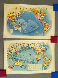
Sold2021Covarrubias Pacific Asia Pictorial Maps (2)Maps of the Pacific, Golden Gate International Exposition. NY, 1942. Miguel Covarrubias (1904-1957). 2 Maps: Peoples and Economy. Australia, Hawaii, Asia, Americas. .See Sold Price
Sold2018Fire Fountains and Other Volumes on Hawaii.[Hawaii] Fire Fountains and Other Volumes on Hawaii. Including Fire Fountains (Edinburgh, 1883) by Cumming, two vols. original pictorial cloth, frontispieces, two maps, plates, mild lean; The HawaiianSee Sold Price
Sold2022(PICTORIAL MAPS.) John Diakoff; G. Primakoff; and P. Sergeeff. Map of China.(PICTORIAL MAPS.) John Diakoff; G. Primakoff; and P. Sergeeff. Map of China. Enormous chromolithographed map of China with profuse pictorial illustration, inset charts, reference tables, and scenic viSee Sold Price
Sold2022(PICTORIAL MAPS.) Ignatz Sahula. Map of the 18th Annual Convention of the National Association of(PICTORIAL MAPS.) Ignatz Sahula. Map of the 18th Annual Convention of the National Association of Real Estate Boards. City of Detroit - June 23 to June 26 1925. Detroit is Yours Realtors! Large color-See Sold Price
Sold2023A Decorative Pictorial Map of The New York Worlds Fair by William L. Longyear (American, 1899-1980)A Decorative Pictorial Map of The New York Worlds Fair by William L. Longyear (American, 1899-1980). Framed. Designed and copyrighted by William Longyear. Lithographed in U.S.A by Polygraphic CompanySee Sold Price
Sold2021Pictorial Map of Nantucket by Austin StrongHand colored in original and great condition, professionally matted and framed, c. 1921, 14 H inches x 17 W inches sight, 23 H inches x 26 W inches, overall. Austin Strong (1881-1952)Austin Strong, stSee Sold Price
Sold2020Pictorial map of Dude Ranches of the WestHeading: (Sportsman's...) Author: Blakeman, T.G. Title: The Sportsman's Dude Ranch Map Place Published: Boston Publisher:The Sportsman Publishing Co. Date Published: 1934 Description: <See Sold Price
Sold2023Lot of 12 Blackinton Made Kauai, Hawaii Police Badges- Officer to ChiefLot of 12 Blackinton made Rho Glo and Hi Glo marked badges to the Kauai, Hawaii Police Department featuring ranks from Chief to Patrolman. Sold without the pictured display case they are resting in.See Sold Price
Sold2020Color pictorial map of Panama Mail Steam Ship routeHeading: (Panama Mail Steamship - color pictorial map) Author: Godwin, Harrison Title: The sea coastes of America shewing the ports of call of the Panama Mail Steamships as the country there aboutes iSee Sold Price
Sold2020Rare pictorial map of Peking 1936Heading: (China - Beijing) Author: Dorn, Frank Title: A Map and History of Peiping, formerly known as Peking... Place Published: Tienstsin-Peiping Publisher:Peiyang Press, Ltd. Date Published: </See Sold Price
Sold2022(PICTORIAL MAPS.) Charles Turzak & Henry Chapman. An Illustrated Map of Chicago • Youthful(PICTORIAL MAPS.) Charles Turzak & Henry Chapman. An Illustrated Map of Chicago • Youthful City of the Big Shoulders • Restless • Ingenious • Wilful • Violent • ProSee Sold Price
Sold2022Marvelous pictorial map of the WorldHeading: (Maps) Author: Ensign & Thayer Title: World at One View Place Published: New York Publisher: Date Published: 1847 Description: Lithographed double-hemisphere map of theSee Sold Price
Sold2023Rosalind H. Sturges, Philadelphia pictorial mapRosalind H. Sturges, Philadelphia pictorial map, Rosalind Howe Sturges (American, 1907-1999), "Philadelphia", drawing on paper, signed and dated "Rosalind H. Sturges, fecit 1966, 70" at lower left, 24See Sold Price
Sold2022(PICTORIAL MAPS.) D.E. Bates. Cunard R.M.S. Caronia / Great African Cruise 1950.(PICTORIAL MAPS.) D.E. Bates. Cunard R.M.S. Caronia / Great African Cruise 1950. Color offset-printed pictorial map advertising the Caronia's route on a two-and-a-half-month's-long affair: departing NSee Sold Price
Sold2022(PICTORIAL MAPS -- INTOXICATION INFATUATION.) H.J. (Heinie) Lawrence. Map Showing Isle of Pleasure,(PICTORIAL MAPS -- INTOXICATION INFATUATION.) H.J. (Heinie) Lawrence. Map Showing Isle of Pleasure, Scale Two Fingers to the Drink. Offset color-printed map of an alcohol-obsessed land loaded with allSee Sold Price
BonhamsWORSLEY (FRANK ARTHUR) Under Sail in the Frozen North, FIRST EDITION, AUTHOR'S PRESENTATION COP...£800
2 days LeftLink Auction GalleriesDry, Camille, N. Pictorial St. Louis: The Great Metropolis of the Mississippi Valley. A$1,500
BonhamsSPEED (JOHN) AND WILLEM BLAEU Pictorial title-pages to Speed's 'Theatre of the Empire of Great B...£10


![1938 R Taylor White Pictorial Map of Hawaii and Samoa: Title: 1938 R Taylor White Pictorial Map of Hawaii and Samoa -- Territory of Hawaii [with] Samoa Cartographer: Ruth Taylor White Year/Place: 1938, Boston Size: 11.6 x 8.5 in. Description: This is Ruth](https://p1.liveauctioneers.com/5584/169916/85621317_1_x.jpg?height=310&quality=70&version=1591137604)
![1938 R Taylor White Pictorial Map of Hawaii and Samoa: Title/Content of Map: 1938 R Taylor White Pictorial Map of Hawaii and Samoa -- Territory of Hawaii [with] Samoa Date Printed: 1938, Boston Cartographer: Ruth Taylor White Size: 11.6 x 8.5 in. This is](https://p1.liveauctioneers.com/5584/117342/60336911_1_x.jpg?height=310&quality=70&version=1520389291)
![1938 R Taylor White Pictorial Map of Hawaii and Samoa -- Territory of Hawaii [with] Samoa: Title: 1938 R Taylor White Pictorial Map of Hawaii and Samoa -- Territory of Hawaii [with] Samoa Cartographer: Ruth Taylor White Year / Place: 1938, Boston Map Dimension (in.): 11.6 x 8.5 in. This is](https://p1.liveauctioneers.com/5584/274166/143946169_1_x.jpg?height=310&quality=70&version=1673389176)

![[HAWAII] Dole Pictorial Map of the Hawaiian Islands.: [HAWAII] Dole Pictorial Map of the Hawaiian Islands. 1937. Offset lithograph. Scarce pre-war pictorial map of the islands, filled with vignettes of the natural and man-made landmarks, modes of transpo](https://p1.liveauctioneers.com/928/200564/101543113_1_x.jpg?height=310&quality=70&version=1618323144)

![Fire Fountains and Other Volumes on Hawaii.: [Hawaii] Fire Fountains and Other Volumes on Hawaii. Including Fire Fountains (Edinburgh, 1883) by Cumming, two vols. original pictorial cloth, frontispieces, two maps, plates, mild lean; The Hawaiian](https://p1.liveauctioneers.com/928/124137/63148761_1_x.jpg?height=310&quality=70&version=1530051387)


