Sold2022(PICTORIAL MAPS.) John Diakoff; G. Primakoff; and P. Sergeeff. Map of China.(PICTORIAL MAPS.) John Diakoff; G. Primakoff; and P. Sergeeff. Map of China. Enormous chromolithographed map of China with profuse pictorial illustration, inset charts, reference tables, and scenic viSee Sold Price
Sold2022[STREETER COPY] SEARCY, I. G. Map of Florida constructed principally from authentic documents in the[STREETER COPY] SEARCY, I. G. Map of Florida constructed principally from authentic documents in the Land office at Tallahassee by I. G. Percy. Published by I.G. Searcy Tallahassee & F. Lucas Jr., BalSee Sold Price
Sold2022[MAPS]. MELISH, John (1771-1821). United States of America Compiled form the latest & bet[MAPS]. MELISH, John (1771-1821). United States of America Compiled form the latest & bet Authorities. Philadelphia: Murray Draper Fairman & Co., 1818. Engraved map of the eastern United States,See Sold Price
Sold2022John Smith Map of New England, Extremely Rare 2nd StateSMITH, John (1580-1631). New England the most remarqueable parts thus named by the high and mighty Prince Charles, Prince of great Britaine. Observed and described by Captayn John Smith... CopperplateSee Sold Price
Sold2022(BERMUDA.) Major General John Henry Lefroy. Map of the Bermudas.(BERMUDA.) Major General John Henry Lefroy. Map of the Bermudas. Hand-colored lithographed wall map of Bermuda with inset diagrams and statistical tables on 4 sheets joined. 51½x60 inches overallSee Sold Price
Sold2021Course of the River Mississipi [sic]"Course of the River Mississipi [sic], from the Balise to Fort Chartres..." map by Lieutenant John Ross of the 34th Regiment, engraved and published with hand-colored outlines by Robert Sayer and JohnSee Sold Price
Sold2015Kingdom of IrelandJohn Speed (1552-1629). Engraved map. London: 1610 (1676). 17 1/4 x 22 inches. A rare, early printing of John Speed’s renowned map of Ireland. The map is decorated with a panel of costume figures deSee Sold Price
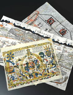
Sold2022Real estate in Balboa Park, S.F.Heading: -1911 Author: Punnett, John M. Title: Map of Mission Terrace San Francisco California Place Published: San Francisco Publisher:Baldwin & Howell Date Published: 1911 DescriptionSee Sold Price
Sold2016JOHN SPEED (BRITISH, 1552-1629) MAP OF THE WORLDJOHN SPEED (BRITISH, 1552-1629) MAP OF THE WORLD, (UPDATED 6/14/16) hand-colored engraving on laid paper, titled "A New and Accurat Map of the World Drawne according to ye truest Descriptions latest DSee Sold Price
Sold2021AI WEIWEI "Map of China" - 2019Ai Weiwei, Chinese (1957-) "Map of China" (from Papercut Portfolio) 2019, Papercut on large format, colored fine art paper. Edition of 250, Signed: Hand signed lower right. Size: 23 5/8 x 23 5/8 incheSee Sold Price
Sold2024A Bulgari, Assioma Chronograph Limited Edition WristwatchA Bulgari, Assioma Chronograph Limited Edition WristwatchRef:AA P 48 G CH limited edition 175 of 199Dial: grey with gilt batons, triple register recording hours, minutes & continuous seconds, date apeSee Sold Price
Sold2022World.- Speed (John) A New and Accurat Map of the World Drawne according to ye truest DescriptionsWorld.- Speed (John) A New and Accurat Map of the World Drawne according to ye truest Descriptions latest Discoveries & best observations yt have beene made by English or Strangers, double-hemisphereSee Sold Price
Sold20241630 MAP OF TARTARY CHINA RUSSIA copper engraving ANTIQUEEarly 17th century map of Tartary, reduced from the larger edition of the map which appeared in the French Mercator-Jodocus Hondius Atlas Minor in the 1630s. Very fine and decorative engraving showingSee Sold Price
Sold2022China.- Ortelius (Abraham) Chinae, olim Sinarum regionis, nova descriptio, 1584 [but slightlyChina.- Ortelius (Abraham) Chinae, olim Sinarum regionis, nova descriptio, detailed map centred on China and based on the work of Jorge de Barbuda, a Portuguese Jesuit also known as Ludovicus GeorgiusSee Sold Price
2024Henry D. Thoreau, Walden; or, Life in the Woods 1st EditionFirst Edition, First Printing, the ads dated "June 1854" and printed prior to the July 1854 publication of the book. Illustrated with the map of Walden Pond at p. 306, with original ribbed brown clothSee Sold Price
Sold2024Western Hemisphere by TallisTitle/Content of Map: Western Hemisphere by Tallis Date Printed: 1851 Cartographer: John Tallis Material/Medium: Engraving Size: 11 x 13 3/4” John Tallis was a British map publisher. He publisheSee Sold Price
Sold2017Mercator (Gerard) - Atlas sive Cosmographicae,Editio Quinta, engraved pictorial title, prelims, 49 double-page maps, including Asia, Russia, Turkey, Lithuania, Asia Minor and Persia, regions of Italy Spain, Germany and Eastern Europe, and 11 singSee Sold Price
Sold20201761 MAP OF NORTH AMERICA BY ROCQUE18th century map GENERAL MAP OF NORTH AMERICA 1754-1761 by John Rocque, London by A. Drury, 2 part map, 35.5 x 36 inches, good condition.See Sold Price
Sold2022PETAVIUS (Dionysius) The History of the World: Or, an Account of Time. London: John Streater 1659,PETAVIUS (Dionysius) The History of the World: Or, an Account of Time. London: John Streater 1659, small folio, folding world map (loose with creases), lacking portrait, contemporary calf, worn with fSee Sold Price
Sold2023MITCHELL'S NEW MAP of TEXAS, OREGON & CALIFORNIA1846 Philadelphia, S. Augustus Mitchell. hardcover leather bound. 5 1/4 x 3 1/4 inches. Map unfolded 22 x 20 1/2 inches and presented in a custom frame 23 1/2 x 22 inches (overall)See Sold Price
Sold2022(CIVIL WAR.) John Bachmann. Panorama of the Seat of War.(CIVIL WAR.) John Bachmann. Panorama of the Seat of War. Portfolio of 6 double-page chromolithographed panoramic perspective maps of Confederate states. Folio, 23½x17 inches, contemporary half moSee Sold Price
Sold2024John Bowles (British 1709 - 1779)John Bowles (British 1709 - 1779) "A New and Exact Map of America Laid Down from the Latest Observations and Discoveries", circa 1750 Two sheet map engraving of the "Representation of the Customs andSee Sold Price
Sold2019China Missions, late 19th century, a small box ofChina Missions, late 19th century, a small box of various China Missionary items and ephemera, including a tissue paper map, passport to Rev. A W Nightingale expiring 1880, signed 'Bullock', printed sSee Sold Price
Sold2020MARSHALL, John: The Life of George WashingtonMARSHALL, John: The Life of George Washington Philadelphia: C.P. Wayne, 1804-1807. 5 volumes plus the Atlas volume of maps and subscriber's names, first edition, Volume II signed 'George Washington',See Sold Price
May 23Forum AuctionsChina.- Audemard (L.) Les Jonques Chinoises, vol. I-VI (of X), first edition, 1957-65; and 12 others£50
1818 AuctioneersTravel. Africa. Roberts, John S. - Africa, and African Travel and Adventure, &c. London: W. P.£10
5 days LeftBonhamsMaharajah Jagatjit Singh of Kapurthala, My Travels in China, Japan and Java, 1903 Hutchinson & C...£1,200
11 hrs LeftPotter & Potter AuctionsSTORM, Mark. Official Texas Brags Map of North America. 194...$200(1 bid)
11 hrs LeftPotter & Potter Auctions[NEW YORK CITY – PICTORIAL MAPS]. Group of 3 pictorial maps...$200(1 bid)
11 hrs LeftPotter & Potter AuctionsBOLLMANN, Hermann (1911 – 1971). Map of New York City. 1962.$100
May 31Freeman's | Hindman[EARLY PHOTOGRAPHY]. A group of 4 stereoviews of an identified photographic wagon and studios, incl.$200
11 hrs LeftPotter & Potter AuctionsPictorial Map of Hollywood and Vicinity / Hollywood Film Ca...$150(2 bids)
11 hrs LeftPotter & Potter AuctionsHANDY, R.D. (1879 – 1959). Paul Bunyan’s Pictorial Map of t...$200(1 bid)
11 hrs LeftPotter & Potter AuctionsWalt Disney World EPCOT Center. 1982. Color pictorial map o...$125
11 hrs LeftPotter & Potter AuctionsLINDGREN, Jolly (1895-1952). A Hysterical Map of Yellowstone Park and the Jackson Hole Country$125
11 hrs LeftPotter & Potter AuctionsRCA Victor Radio, Amusement and Educational Map of the Worl...$100
11 hrs LeftPotter & Potter AuctionsLINDGREN, Hjalmer “Jolly” (1895–1952). A Hysterical Map of ...$200
11 hrs LeftPotter & Potter AuctionsCrosby Service Pictorial Map of Manhattan (New York City). ...$250
11 hrs LeftPotter & Potter AuctionsLINDGREN, Hjalmer “Jolly” (1895–1952). A Hysterical Map of ...$150(1 bid)
11 hrs LeftPotter & Potter AuctionsPan American Airways World System Map. 1956. Art by John Br...$200
11 hrs LeftPotter & Potter AuctionsDisneyland. 1968. Walt Disney Productions. This 1968 versio...$125
11 hrs LeftPotter & Potter AuctionsMcCARTY, Lea (1905 – 1960). Sonoma County / Its Highlights ...$100(1 bid)
11 hrs LeftPotter & Potter AuctionsCRAVATH, Glen (1897 – 1964). Py Your Leaf Baron Munchausen ...$80


![[STREETER COPY] SEARCY, I. G. Map of Florida constructed principally from authentic documents in the: [STREETER COPY] SEARCY, I. G. Map of Florida constructed principally from authentic documents in the Land office at Tallahassee by I. G. Percy. Published by I.G. Searcy Tallahassee & F. Lucas Jr., Bal](https://p1.liveauctioneers.com/292/250642/130213737_1_x.jpg?height=310&quality=70&version=1654271664)
![[MAPS]. MELISH, John (1771-1821). United States of America Compiled form the latest & bet: [MAPS]. MELISH, John (1771-1821). United States of America Compiled form the latest & bet Authorities. Philadelphia: Murray Draper Fairman & Co., 1818. Engraved map of the eastern United States,](https://p1.liveauctioneers.com/197/265300/138516600_1_x.jpg?height=310&quality=70&version=1666052782)


![Course of the River Mississipi [sic]: "Course of the River Mississipi [sic], from the Balise to Fort Chartres..." map by Lieutenant John Ross of the 34th Regiment, engraved and published with hand-colored outlines by Robert Sayer and John](https://p1.liveauctioneers.com/1007/196938/99435775_1_x.jpg?height=310&quality=70&version=1615322535)


![[NEW YORK CITY – PICTORIAL MAPS]. Group of 3 pictorial maps... (1 of 3)](https://p1.liveauctioneers.com/928/325952/175495562_1_x.jpg?height=282&quality=70&version=1712935174)

![[EARLY PHOTOGRAPHY]. A group of 4 stereoviews of an identified photographic wagon and studios, incl. (1 of 2)](https://p1.liveauctioneers.com/197/329785/177758511_1_x.jpg?height=282&quality=70&version=1715625218)


![[MAP]. SPEED, John. A New Mappe of the Romane Empire. 1676. (1 of 2)](https://p1.liveauctioneers.com/197/329395/177650541_1_x.jpg?height=282&quality=70&version=1715364962)


