Sold2024Siam and the Malay Archipelago. Indonesia Indochina Philippines. TIMES 1895 mapTITLE/CONTENT OF MAP: 'Siam and the Malay Archipelago' DATE PRINTED: 1895 IMAGE SIZE: Approx 38.5 x 25.5cm, 15.25 x 10 inches (Large) TYPE: Antique colour atlas map CONDITION: Good; suitable for framiSee Sold Price
Sold2019The Times 1895 Pair of Maps. East Indies, Asia"Siam and the Malay Archipelago" and "Burma and the Malay Peninsula" Lithograph Maps Published 1895, London for "The Times Atlas" Paper Size: 16 x 10.5 inch (41 x 27cm) Good ConditionSee Sold Price
Sold2019Bartholomew, John 1922 Pair Large Maps of East Indies"Farther India" showing Siam, Indonesia, Singapore, Malaysia. Together with "Malay Archipelago" Large Lithograph Map Published 1922 by The Times, London for "The Times Survey Atlas of the World" MapsSee Sold Price
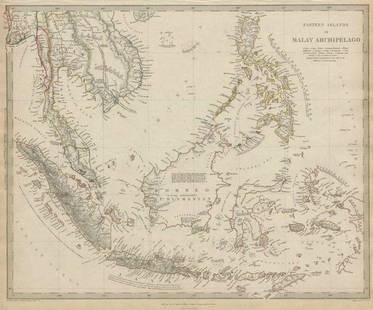
Sold2020MALAY ARCHIPELAGO Indonesia Malaysia PhilippinesTITLE/CONTENT OF MAP: 'EASTERN ISLANDS OR THE MALAY ARCHIPELAGO. Sumatra, Java, Borneo, etc' The top image on the right hand side shows the entire map. To view a close up of the map showing the levelSee Sold Price
Sold2020MALAY ARCHIPELAGO Indonesia Malaysia PhilippinesTITLE/CONTENT OF MAP: 'EASTERN ISLANDS OR THE MALAY ARCHIPELAGO. Sumatra, Java, Borneo, etc' The top image on the right hand side shows the entire map. To view a close up of the map showing the levelSee Sold Price
Sold2022Times Atlas 1895 Map. Siam and MalaysiaLithograph Map Published 1895, London for "The Times Atlas" Paper Size: 16 x 10 inch (41 x 26cm) Good ConditionSee Sold Price
Sold2022Universal Atlas 1893 LG Map. Siam and the Malay ArchipelagoLithograph Map Published 1893 by Cassell & Co., London for "The Universal Atlas" Centre fold as issued. Paper Size: 16 x 10.5 inch (41 x 27cm) Good ConditionSee Sold Price
Sold2022Times Atlas 1895 Lot 3 Maps. Siam, China, Burma, MalayaLithograph Map Published 1895, London for "The Times Atlas" Two with Centre fold as published. Up to Paper Size: 16 x 10 inch (41 x 26cm) Good ConditionSee Sold Price
Sold2019Gross, Alexander 1920 Pair of Large Maps. East Indies"French Indo-China, Siam & Malay States" and "East Indies" Large Lithograph Maps Published 1920, London for "The Daily Telegraph Victory Atlas of the World" by Alexander Gross. Centre fold as publisheSee Sold Price
Sold2019Malaya 1911-1922 Pair of Maps of the East IndiesBoth titled "Malay Archipelago" Large Lithograph Maps Published 1922 by The Times, London for "The Times Survey Atlas of the World" Maps by John George Bartholomew of the Edinburgh Geographical InstitSee Sold Price
Sold2020Bartholomew, John 1922 Pair of Maps. East Indies"Farther India" and "Malay Archipelago" Large Lithograph Maps Published 1922 by The Times, London for "The Times Survey Atlas of the World" Maps by John George Bartholomew of the Edinburgh GeographicaSee Sold Price
Sold2019Bartholomew, John 1922 Group of 3 Maps of AsiaSouth Western Asia, Asia - Political, and Father India showing Siam and Indo China. Large Lithograph Maps Published 1922 by The Times, London for "The Times Survey Atlas of the World" Maps by John GeoSee Sold Price
Sold2021MALAY ARCHIPELAGO/EAST INDIA ISLANDS PhilippinesTITLE/CONTENT OF MAP: 'Malay Archipelago or East India Islands' Vignettes: Victoria Mount - New Guinea; Near Sarawak - Borneo; Natives of New Guinea; The Bee Bear. The map covers the area from Burma aSee Sold Price
Sold2018Eastern Islands Or Malay ArchipelagoMap: Eastern Islands Or Malay Archipelago Date: 1852 Cartographer: WALKER, J. & C. Publisher: GEORGE COX/S.D.U.K. Size (inches): 12.5X16 Map showing southern Siam, Archipelago Filipino, Celebes, BorneSee Sold Price
Sold20201898 Rand McNally Map of Asia from China, Japan toTitle/Content of Map: 1898 Rand McNally Map of Asia from China, Japan to Indonesia -- China, French Indo-China, Siam, Malaysia & Korea Cartographer: Rand McNally Year/Place: 1898, Chicago Size: 18.6 xSee Sold Price
Sold2023FRENCH INDOCHINA & DUTCH EAST INDIES Siam Burma Penang Manila Singapore 1912 mapTitle: FRENCH INDOCHINA & DUTCH EAST INDIES Siam Burma Penang Manila Singapore 1912 map Description: Farther India; East Indies Archipelago; Inset maps of Singapore; Penang; Manila' by John BartholomeSee Sold Price
Sold2024East India islands & Indochina. Dutch E. Indies. Philippines. THOMSON 1817 mapTITLE/CONTENT OF MAP: East India Isles [and Birman Empire] A large map of the Dutch East Indies, Indochina and the Philippines. "Pinang" (Penang), "Bankok" (Bangkok), "Manilla" (Manila), and the StraiSee Sold Price
Sold2022Wallace. The Malay Archipelago. 2 vols. in one.[Exploration] Wallace, Alfred Russel. The Malay Archipelago: The Land of the Orang-Utan, and the Bird of Paradise. A Narrative of Travel, with Studies of Man and Nature. Macmillan, London, 1869. 2 volSee Sold Price
Sold2021[TRAVEL & EXPLORATION]. -- WALLACE, Alfred Russel[TRAVEL & EXPLORATION]. -- WALLACE, Alfred Russel (1823-1913). The Malay Archipelago: The Land of the Orang-utan, and the Bird of Paradise.... London: MacMillan and Co., 1869. 2 volumes, 8vo. Half-titSee Sold Price
Sold2019Victorio Edades, Philippines (1895-1985)Victorio Edades, Philippines (1895-1985), Signed and Dated (lower right), 1976, oil on canvas, 22\"x30”, Provenance: Private Collection, San Francisco, California U.S.A.See Sold Price
Sold2022Antonio Maria Blanco (1911 - 1999)Antonio Maria Blanco (New York, California / Indonesia, Philippines, 1911 - 1999) Original mixed media painting on paper. Possibly a late self-portrait. Signed verso. Housed in likely the original artSee Sold Price
Sold2019Victorio Edades, Philippines (1895-1985)Victorio Edades, Philippines (1895-1985), Signed and Dated (lower right), oil on canvas, 16.5\"x17.5”, Provenance: Private Collection, San Francisco, California U.S.A.See Sold Price
Sold2023Ethnographic Collectors Lot of 8 Spoons, Indonesia and PhilippinesEthnographic Collectors Lot of 8 Spoons, Indonesia and Philippines. Dayak, Timor. Size: Ranging from 4.5'' x 2'' x 1.75'' (11 x 5 x 4 cm) to 10'' x 2.5'' x 2'' (25 x 6 x 5 cm).See Sold Price
Sold2022ARROWSMITH, AARON. Chart of the Pacific Ocean.ARROWSMITH, AARON. Chart of the Pacific Ocean. Large engraved navigational chart of the coastlines of Russia, Japan, Korea, China, the Philippines, Indonesia, and Australia. 73¼x31½ inches oSee Sold Price
2 days LeftJasper521652 Sanson Map of Parts od Southeast Asia -- Les Isles de la Sonde. Entre Lesquelles sont Sumatra,$200
Jun 08Leon GalleryAbraham Ortelius (1527 - 1598) - Indiae Orientalis (Philippines/China/ India/ Southeast Asia)₱200,000
4 days LeftNY Elizabeth FIRST US EDITION OF 1869 MALAY ARCHIPELAGO BY A.WALLACE, ANTIQUE ILLUSTRATED WITH MAPS$50(1 bid)
Jun 23Schilb Antiquarian Rare BooksUS War w/ SPAIN 1898 1ed Puerto Rico CUBA Philippines MAPS Russell Illustrated$76(4 bids)
4 days LeftDawsons AuctioneersJames Lynwood Palmer (1865-1941), 'Superba' - a carriage driving pair with riders, signed 'Lynwood£1,800
Jun 08Simpson Galleries, LLC.JULIUS BIEN (1826-1909) AN AMERICAN CIVIL WAR RECONNAISSANCE MAP, "Map of Texas and Part of New$100
Jun 02Schilb Antiquarian Rare Books1871 Alfred the Great King of England MAP Battle of Ashdown Vikings Thom Hughes$125(3 bids)
2 days LeftJasper521895 AN ARTIST IN THE HIMALAYAS by A.McCORMICK illustrated antique TRAVEL$120(1 bid)
Jun 02White Knight Auction, IncHenri Cartier Bresson, Bali Indonesia, 1950 End Of Preperations For A Dance$100
Jun 07Freeman's | HindmanHARDY, Thomas. The Wessex Novels. 1895-97. FIRST UNIFORM AND COLLECTED EDITION.$300
Jun 08Leon GalleryRobert Dudley (1573 - 1649) - Carta particolare del'Isola Mindano parte Australe con Celebes e₱500,000


![East India islands & Indochina. Dutch E. Indies. Philippines. THOMSON 1817 map: TITLE/CONTENT OF MAP: East India Isles [and Birman Empire] A large map of the Dutch East Indies, Indochina and the Philippines. "Pinang" (Penang), "Bankok" (Bangkok), "Manilla" (Manila), and the Strai](https://p1.liveauctioneers.com/5584/320546/172232433_1_x.jpg?height=310&quality=70&version=1709072904)
![Wallace. The Malay Archipelago. 2 vols. in one.: [Exploration] Wallace, Alfred Russel. The Malay Archipelago: The Land of the Orang-Utan, and the Bird of Paradise. A Narrative of Travel, with Studies of Man and Nature. Macmillan, London, 1869. 2 vol](https://p1.liveauctioneers.com/179/268856/140616095_1_x.jpg?height=310&quality=70&version=1668545725)
![[TRAVEL & EXPLORATION]. -- WALLACE, Alfred Russel: [TRAVEL & EXPLORATION]. -- WALLACE, Alfred Russel (1823-1913). The Malay Archipelago: The Land of the Orang-utan, and the Bird of Paradise.... London: MacMillan and Co., 1869. 2 volumes, 8vo. Half-tit](https://p1.liveauctioneers.com/197/222511/114585326_1_x.jpg?height=310&quality=70&version=1634328599)


