Sold2017Mitchell: Antique Map of North America, 1864Title: Map of North America by Mitchell Date: 1864 Dimensions (inches): 12 x 15 Medium: Hand Colored Lithograph Good Condition, little bit of foxing Samuel Augustus Mitchell (1790-1860) was an AmericaSee Sold Price
Sold2019A. J. Johnson, "Comparative Heights of Mountains, andA. J. Johnson, "Comparative Heights of Mountains, and Lengths of Rivers in Africa, Asia, Europe, South America, North America," hand colored, 1864, 26 3/8 in., W.- 18 1/8 in.See Sold Price
Sold2024Rare 1864 American 2 Cent Coin Small MottoNorth America, United States, ca. 1864 CE. A nicely preserved American 2 cent coin from 1864 containing a "small motto" where the letters for "IN GOD WE TRUST" on the verso are shorter than those usedSee Sold Price
Sold2022A FEDERAL PERIOD MAP, "North America," LONDON, CIRCA 1816,A FEDERAL PERIOD MAP, "North America," LONDON, CIRCA 1816, CHARLES SMITH (1803-1864), hand colored copper plate engraving on paper, plate no. 49, publisher in margin, "London. Published by C. Smith. NSee Sold Price
Sold202120th C. Northwest Coast Walrus Ivory Totem PoleNative American, North America, Pacific Northwest Coast, probably Alaska, ca. mid-20th century CE. A hand-carved walrus ivory totem pole of a slender form presented atop a separately carved rectangulaSee Sold Price
Sold2021Early 20th C. Northwest Coast Walrus Ivory Totem PoleNative American, North America, Pacific Northwest Coast, probably Alaskan Inuit, ca. early 20th century CE. A hand-carved walrus ivory totem pole of a slender, three-part form bearing fine detailing aSee Sold Price
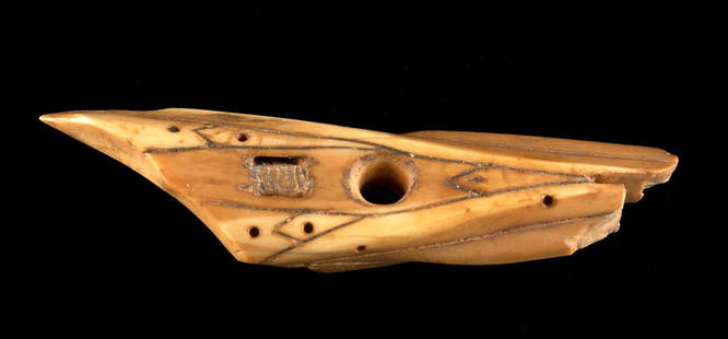
Sold2022Pre-Contact Inuit Walrus Ivory Harpoon PointNative American, North America, Pacific Northwest Coast, Alaska, St. Lawrence Island, Inuit, Punuk stage, ca. 500 to 1000 CE. A hand-carved walrus ivory harpoon point of an elongated triangular form wSee Sold Price
Sold2022Folk Art Beechwood Walrus Sculpture by Sarreid**Originally Listed At $900** North America, United States, ca. 1977 CE. This is a charming and unique sculpture of a walrus, hand carved from beech wood with copper sheet tusks. The face is deeply inSee Sold Price
Sold20211864 US Civil War Promotion & Pardon Letters, Deshazo**First Time At Auction** North America, United States, Alabama, Civil War era, ca. 1864 & 1865 CE. A pair of documents from the American Civil War both pertaining to the Confederate soldier, Rufus MoSee Sold Price
Sold2019Three Maps: consisting of Johnson & Ward, "UnitedThree Maps: consisting of Johnson & Ward, "United States," 1864, hand colored, H.- 17 7/8 in., W.- 26 1/2 in.; together with two copies of Johnson & Ward, "North America," 1861-1863, H.- 26 1/2 in., WSee Sold Price
Sold20211864 Johnson Chart of Mountains and Rivers perTitle: 1864 Johnson Chart of Mountains and Rivers per Continent -- Johnson's Chart of Comparative Heights of Mountains and Lengths of Rivers of Africa, Asia, Europe, South America and North America CaSee Sold Price
Sold2023C.1860-1864 Confederate States of America MoneyFeatured in this lot is a framed collection of three Confederate States of America monetary bills from 1862-1864. The Confederate States of America dollar was first issued just before the outbreak ofSee Sold Price
Sold2022History of the Indian Tribes of North America by Thomas McKenney and James Hall, Vol. I & IIHistory of the Indian Tribes of North America by Thomas McKenney and James Hall, Vol. I & II Volume I, Philadelphia: Published by Edward C. Biddle, 23 Minor Street. 1836. Volume II, Philadelphia: PublSee Sold Price
Sold20201761 MAP OF NORTH AMERICA BY ROCQUE18th century map GENERAL MAP OF NORTH AMERICA 1754-1761 by John Rocque, London by A. Drury, 2 part map, 35.5 x 36 inches, good condition.See Sold Price
Sold2016Map of North America...David H. Vance, engraved by J.H. Young. Philadelphia: Anthony Finley, 1825. Engraved map in 5 parts with original hand color in outline. 25 7/8 x 20 1/2 inches sheet, 30 5/8 x 25 1/2 inches framed.See Sold Price
Sold2022Seymour & Birch View of the City of New York in New York State, North AmericaSEYMOUR, Samuel (Active, 1797-1823), After William BIRCH (1755-1834). The City of New York in the State of New York, North America. Engraving with hand color by William H. Morgan, Philadelphia. BristaSee Sold Price
Sold2017McKenney & Hall, "Indian Tribes of North America"Thomas L. McKenney (American, 1785-1859) and James Hall (American, 1793-1868) History of the Indian Tribes of North America Philadelphia: D. Rice and A. N. Hart, 1855, octavo edition complete in threeSee Sold Price
Sold2023Zuber Views of North America Wall Paper CompleteAntique Zuber and Co. Panoramic Wallpaper "Les Vues d'Amerique du Nord" Includes Complete Wall Paper Panels. These panels were professionally removed from a New York Estate and are offered in the origSee Sold Price
Sold2023(AMERICAN INDIANS.) Thomas McKenney and James Hall. History of the Indian Tribes of North America.(AMERICAN INDIANS.) Thomas McKenney and James Hall. History of the Indian Tribes of North America. 120 hand-colored lithograph plates plus a hand-colored dedication leaf. iv, 333; xvii, 9-290; iv, 18-See Sold Price
Sold2024Map of United States of North America, 1785Map of United States of North America, 1785, The Royal Islands of Newfoundland. 26 3/4 x 32 3/4 in framed. 19 x 25 in unframed.Local Pick up call one day before to make an appointment. TO SHIP THIS ITSee Sold Price
Sold2023AUDUBON, John James and John BACHMAN. The Quadrupeds of North America. FIRST OCTAVO EDITION.AUDUBON, John James (1785-1851) and John BACHMAN (1790-1874). The Quadrupeds of North America. New York: V.G. Audubon, 1849, 1851, 1854. 3 volumes, 8vo (265 x 177 mm). Half-titles, 155 hand-colored liSee Sold Price
Sold20241719 Map of Colonial era North America, by Sanson - JaillotTitle: 1719 Map of Colonial era North America, by Sanson - Jaillot Date/Period: 1719 Materials: Copperplate engraved Size: 25 1/2 x 18” This map is a rare and valuable map of history, showing NoSee Sold Price
Sold2022BODMER, Karl. Indians Hunting the Bison (Tab. 31). From Travels in the Interior of North America, BODMER, Karl (1809-1893) Indians Hunting the Bison (Tab. 31). From Travels in the Interior of North America, Coblenz, Paris, and London, 1839-1842. Aquatint engraving with hand-coloring, BodmerSee Sold Price
Sold2023(NORTH AMERICA.) Henricus Hondius. America Septentrionalis.(NORTH AMERICA.) Henricus Hondius. America Septentrionalis. Double-page engraved map of North America with California as an island and attractive carto-ornamentation. 19¼x23½ inches sheet siSee Sold Price
7 days LeftHolabird Western Americana CollectionsArizona and Sonora: Silver Region of North America [181719]$100
Jul 07A-1 Auction(2) 1864 Confederate States of America Loan Bond $1000 2nd & 3rd Series by E. Apperson$125(3 bids)
20 hrs LeftCottone AuctionsBowles and Carver, "A South-West View of the City of New York in North America" and "A South-East$150
2 days LeftTrillium Antique Prints & Rare BooksCollot's A Journey in North America - Atlas Volume with 36 Maps$200(1 bid)
Jun 23Schilb Antiquarian Rare Books1860 Voyages of Jonathan Carver INDIANS North America Mississippi Natchez Tours$1(1 bid)
Jun 07Freeman's | HindmanHARMON, Daniel Williams. A Journal of Voyages and Travels in the Interiour of North America. 1820.$450(2 bids)
2 days LeftTrillium Antique Prints & Rare BooksSanson - Map of Florida (encompassing most of Southeast North America)$130(2 bids)
5 days LeftJasper521861 Map of Western US -- Reduced Section of a General Map of North America, Drawn from the Best$40
7 days LeftHolabird Western Americana CollectionsProspecting Gold & Silver North America 1896 [181923]$75
7 days LeftHolabird Western Americana CollectionsBank of North America Prior to 1846 by Lewis [182234]$75
7 days LeftHolabird Western Americana CollectionsExploratory Travels Western Territories of North America, 1889 [181935]$200
7 days LeftHolabird Western Americana CollectionsHistory Indian Tribes of North America, 3 Volumes [182229]$250
7 days LeftHolabird Western Americana CollectionsIndian Tribes of North America by Volair, 2 Vols., 1978 [182721]$400


![Arizona and Sonora: Silver Region of North America [181719] (1 of 7)](https://p1.liveauctioneers.com/2699/331494/178785577_1_x.jpg?height=282&quality=70&version=1717094654)


![Prospecting Gold & Silver North America 1896 [181923] (1 of 5)](https://p1.liveauctioneers.com/2699/331494/178785591_1_x.jpg?height=282&quality=70&version=1717094654)
![Bank of North America Prior to 1846 by Lewis [182234] (1 of 5)](https://p1.liveauctioneers.com/2699/331494/178785559_1_x.jpg?height=282&quality=70&version=1717094654)
![Exploratory Travels Western Territories of North America, 1889 [181935] (1 of 5)](https://p1.liveauctioneers.com/2699/331494/178785474_1_x.jpg?height=282&quality=70&version=1717094654)
![History Indian Tribes of North America, 3 Volumes [182229] (1 of 7)](https://p1.liveauctioneers.com/2699/331494/178785297_1_x.jpg?height=282&quality=70&version=1717094654)
![Indian Tribes of North America by Volair, 2 Vols., 1978 [182721] (1 of 8)](https://p1.liveauctioneers.com/2699/331494/178785301_1_x.jpg?height=282&quality=70&version=1717094654)


