Sold2017Schenk: Map of S. Salvador, 1699Map: S. Salvador Cartographer: Schenk Place & Date: Amsterdam / 1699 Size: 10 1/4" x 8 3/8" The rare Schenk reissue of Allard's view of Salvador da Bahia, Brazil, with shipping in the harbor and the wSee Sold Price
Sold2020Guillaume de L'Isle and Peter Schenk MapGuillaume de L'Isle and Peter Schenk "L'Amerique Septentrionale Dressee sur les Observations...", Amsterdam, Pierre Schenk, 1708, hand-colored engraved map, 17 1/2 in. x 23 in., matted and framed ProvSee Sold Price
Sold2019Schenk Map of RussiaSCHENK, Petrus (1660-1711). La Russie Blanche Moscovie... Engraved map with original color. Amsterdam, c. 1700. 21 1/8" x 25" sheet. Handsome map showing the extent of the Russian Empire in Europe. ThSee Sold Price
Sold20201750 c. Schenk Map of Eastern Germany Centered onTitle: 1750 c. Schenk Map of Eastern Germany Centered on Dresden -- Dem Durchlauchtigsten Fursten und Herrn Herrn Friedrich Augusto... Cartographer: P Schenk II Year/Place: 1750 c., Amsterdam Size: 19See Sold Price
Sold2020Geography Anatomiz'd w/16 maps 1699Heading: Author: Gordon, Patrick Title: Geography Anatomiz'd: or, the Geographical Grammar: Being a Short and Exact Analysis of the whole Body of Modern Geography after a New and Curious Method PlaceSee Sold Price
Sold2017Sanson: Antique Map of Americas with Atlantis, 1699Map: 1699 Sanson Map of Americas with Mythical Atlantis and California as Island -- Atlantis Insula, a Nicolao Sanson Antiquitati Restituta; nunc demum Majori Forma Delineata, et in Decem Regna, iuxtaSee Sold Price
Sold2022(MEXICO.) Henry Schenk Tanner. A Map of the United States of Mexico,(MEXICO.) Henry Schenk Tanner. A Map of the United States of Mexico, As Organized and Defined by the Several Acts of Congress of that Republic. Large hand-colored lithographed map of southwestern NortSee Sold Price
Sold2017Mallet: Antique Map of San Salvador, the Bahamas, 1683Map: I. de Guanahani ou de St. Salvador Cartographer: Mallet Place & Date: Paris / 1683 Size: 3 3/4" x 5 1/2" Condition: wash color; overall age-toning and some browning along edges of margins A charmSee Sold Price
Sold2023CENTRAL AMERICA. Costa Rica, Guatemala, Honduras, Nicaragua, Belize 1903 mapCentral America: Costa Rica, Guatemala, Honduras, Nicaragua, Salvador; Inset map of Lake Nicaragua and Nicaragua Canal' by Britannica, Encyclopaedia (1903). Colour antique lithographic map, 28.0 x 39.See Sold Price
2023CENTRAL AMERICA. Costa Rica, Guatemala, Honduras, Nicaragua, Belize 1903 mapTitle: CENTRAL AMERICA. Costa Rica, Guatemala, Honduras, Nicaragua, Belize 1903 map Description: Central America: Costa Rica, Guatemala, Honduras, Nicaragua, Salvador; Inset map of Lake Nicaragua andSee Sold Price
Sold2017Berey / Ertinger: Antique Map of Judea / Israel, 1699Map: Nova descriptio Judaeae et totius Terrae Israel Cartographer: Berey/Ertinger Place & Date: Rouen / 1699 Size: 14 7/8" x 10 3/4" Condition: b&w; light overall age toning The beautifully detailed aSee Sold Price
Sold2023SALVADOR DALI 'BABY MAP OF THE WORLD' LITHOGRAPHSalvador Dali lithograph titled 'Baby Map of the World'. Hand signed lower right. Numbered XCVIII/MM and holds blindstamp lower left. Measures 25 3/4" x 19 3/4".See Sold Price
Sold2023[MAP]. FRY & JEFFERSON. A Map of the Most Inhabited Part of Virginia. 1775. FIRST PRINTED MAP OF[MAPS & ATLASES]. FRY, Joshua (1699-1754) and Peter JEFFERSON (1708-1757). A Map of the Most Inhabited Part of Virginia containing the whole Province of Maryland with Part of Pensilvania, New JersSee Sold Price
Sold2017Vintage Metallic Paper Peter Shenk Map of WorldVintage Metallic Gold Foil Embellished Paper Shenk Map of the World, with a reverse painted black mat on the frame's glass. Copy of an 18th century world map by Peter Schenk the elder (1645-1715). FraSee Sold Price
Sold2024Nicolas De Fer (French 1646-1720)Nicolas De Fer (French 1646-1720) "L Amerique Méridionale, et Septentrionale" early state hand colored map engraving dated lower right "1699" 18" x 23" Condition: overall good condition, some yellowiSee Sold Price
Sold2019Sixr Maps by Jean Baptiste D'Anville (1699-1782), Two-Sixr Maps by Jean Baptiste D'Anville (1699-1782), Two- "A Map of South America Containing Tierra-Firrna, Guyana, New Granada/London Amazonia, Brassil, Peru, Parguay, Chaco, Tucuman, Chili, Patagonia,"See Sold Price
Sold2022[GREAT LAKES REGION]. A pair of engraved maps, including: T...[GREAT LAKES REGION]. A pair of engraved maps, including: TANNER, Henry Schenk. North America: Sheet V The Northwest and Michigan Territories. London Baldwin & Cradock, 1833. Hand–outlined in coSee Sold Price
Sold20181699 Bible Commentary Holy Land Maps Gospel Harmony1699 Bible Commentary Holy Land Maps Gospel Harmony Latin Bernard Lamy Bernard Lamy was a 17th-century French theologian whose book ‘Harmonia, sive Concordia’ struck controversy among many FrenchSee Sold Price
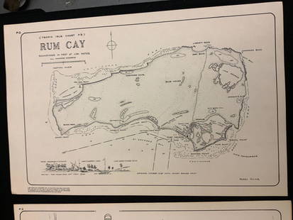
Sold2021Boating maps, rum cay, conception island, San Salvador.Maps from 1981 tropic Isle publishers, Inc By Harry Kline, Rum Cay, Conception island, San Salvador. Size 11“ x 17“See Sold Price
Sold2019Two Maps by Jean Baptiste D'Anville (1699-1782), "Two Maps by Jean Baptiste D'Anville (1699-1782), " America Septentrionales, Coloniis lnteriorem Virginiam deductis, Ohio," 1756 and 1777, H. - 20 in., W. - 23 5/8 in. (2 Pcs.)See Sold Price
Sold2015Salvador Dali, (Spanish, 1904-1989), The Tree ofSalvador Dali, (Spanish, 1904-1989), The Tree of Punishment and Meeting of Dante and Beatrice (a pair), lithographs, 9.75" x 7"See Sold Price
Sold2020Henricus Hondius 1650 Map of America(Amsterdam, 1597-1651) Very nicely detailed hand colored map of the US of the period predating that of Petrus Schenk. The piece has exceptional colors and has been professionally framed and acid freeSee Sold Price
Sold2024Adam Friedrich Zurner (German 1679 - 1742) and Peter Schenk (German 1660 - 1711)Adam Friedrich Zurner (German 1679 - 1742) and Peter Schenk (German 1660 - 1711) "Americae tam Septentionalis quam Meridionalis in Mappa Geographica Delineato", circa 1709 Hand colored map engraving 2See Sold Price
Featured9 hrs LeftJasper52SOUTHERN MEXICO & CENTRAL AMERICA. Yucatan Belize Mosquito Coast.SDUK 1844 map$35
9 hrs LeftJasper52La partie méridionale du Brésil et du Perou. SANTINI/D'ANVILLE 1784 old map$80


![[MAP]. FRY & JEFFERSON. A Map of the Most Inhabited Part of Virginia. 1775. FIRST PRINTED MAP OF: [MAPS & ATLASES]. FRY, Joshua (1699-1754) and Peter JEFFERSON (1708-1757). A Map of the Most Inhabited Part of Virginia containing the whole Province of Maryland with Part of Pensilvania, New Jers](https://p1.liveauctioneers.com/197/305583/163286504_1_x.jpg?height=310&quality=70&version=1697143109)


![[GREAT LAKES REGION]. A pair of engraved maps, including: T...: [GREAT LAKES REGION]. A pair of engraved maps, including: TANNER, Henry Schenk. North America: Sheet V The Northwest and Michigan Territories. London Baldwin & Cradock, 1833. Hand–outlined in co](https://p1.liveauctioneers.com/928/252933/131521733_1_x.jpg?height=310&quality=70&version=1656110480)