Sold2022Scarce map of Pittsburg and Allegheny by Geo. F. CramScarce and huge doubler-page map showing “Pittsburg” and the now bygone municipality of Allegheny, annexed by Pittsburgh in 1907. This map comes the extremely scarce 1910 edition of CramâSee Sold Price
Sold2022Scarce Railroad map of St. Louis by Geo. F. CramDetailed and scarce 1910 double-page map of St. Louis showing railway routes. Interestingly, it also locates every interurban route in the city, a most unusual addition. This map comes the extremely sSee Sold Price
Sold2020IndianaTitle/Content of Map: Indiana Cartographer: CRAM, GEO. F. Date: 1883 Publisher: CRAM, GEO. F. Size: 21.5Height - 15.3Width Scarce. Map detailing counties, towns, townships, rivers, creeks and excellenSee Sold Price
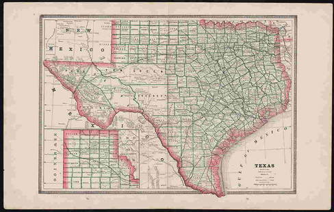
Sold2022Clean 1883 RR map of Texas, Geo. F. CramInteresting cerographic map of Texas from Cram’s Unrivaled Family Atlas of the World. Predates subdivision of Tom Green, Pecos, Crockett and Presidio Counties. Shows rail system throughout statSee Sold Price
Sold2023Authentic 1888 Railroad map of Colorado from Geo. F. CramPainstaking delineation of topography in this really nice map of Colorado. Shows and names each line of the rail system in place at this time. Locates towns, rivers, springs, forts, military reservatiSee Sold Price
Sold2019Eleven (11) 19th Century MapsIncluding Map of the State of Arkansasby TAINTOR BROS & MERRILL, Map of Wisconsin by Geo. F Cram, Johnson's NEW BRUNSWICK Nova Scotia, NEWFOUNDLAND and Prince Edward P. By Johnson and Ward Washington,See Sold Price
Sold2017Cram's Rail Road & Township Map of Wisconsin. 1876[Midwest] Pocket map: CRAM’S RAIL ROAD & TOWNSHIP MAP OF WISCONSIN. Chicago: Geo. F. Cram, 1876. 20 ¾ x 16 in., full hand coloring, original pictorial wrappers. Lower horizontal fold partly split,See Sold Price
Sold2017Cram: Antique Map of Nevada[Nevada]. Chicago: Geo. F. Cram, n.d. Coloured map. ca.1800. Approximately 20-3/4 x 13-3/4 inches image area, printed in black on cream paper, with hand colouring. Matted and shrink wrapped. Fine. TheSee Sold Price
Sold2023Pittsburgh and Allegheny CityPublication Date: 1892 Title: Pittsburgh and Allegheny City Cartographer: CRAM, GEORGE F. Publisher: GEO. F. CRAM & CO. Height: 12.6 Width: 18.25 120-121. From: Cram's Unrivaled atlas of the world. inSee Sold Price
Sold2020Map of Alaska. Copyright Secured 1897 by Geo. F.Title: Map of Alaska. Copyright Secured 1897 by Geo. F. Cram... Chicago, Illinois Publication Date: 1897 Cartographer: CRAM, GEORGE F. Publisher: GEO. F. CRAM Size: 12 x 20.1 Hemisphere maps on reversSee Sold Price
Sold2020FloridaTitle: Florida Publication Date: 1884 Cartographer: Cram, Geo. F. Publisher: Cram, Geo. F. Brief Descriptions: Map showing counties, towns, railroads, townships and inset of panhandle of FL. Rev: AlabSee Sold Price
Sold2020New MexicoTitle: New Mexico Publication Date: 1885 Cartographer: CRAM, GEO. F. Publisher: CRAM, GEO. F. Brief Descriptions: Map showing counties, towns, townships, Indian reservations, railroads and topography.See Sold Price
Sold2018Cram's RailRoad & Township Map of Washington.Title: Cram's RailRoad & Township Map of Washington. Publication Date: 1881 Cartographer: GEO. F. CRAM Publisher: GEO. F. CRAM Size: 15.5X19 Published for Geo. F. Cram. Proprietor of the Western Map DSee Sold Price
Sold2018Cram: Antique Map of Japan, 1906Title/Content of Map: Japan Cartographer: CRAM, GEORGE F. Size: 13X16.5 "Published by Geo. F. Cram, Chicago, Ill." From Grant's Bankers' and Brokers' railway system atlas, cover dated 1906. On polar pSee Sold Price
Sold2019Map of BaltimoreTitle: Map of Baltimore Publication Date: 1895 Cartographer: CRAM, GEO. F. Publisher: GEO. F. CRAM Dimensions: 18.1 X 12.5 Additional Information: From Cram's Universal atlas,... All streets named orSee Sold Price
Sold2019Official Map of CubaTitle/Content of Map: Official Map of Cuba Date: c1898 Cartographer: CRAM, GEORGE F. Publisher: GEO. F. CRAM, Size: 13Height - 20.25Width Double-page atlas map with inset plan of Havana. On reverse, mSee Sold Price
Sold20211880s Birdseye View of Holy Land, Geo. F. CramDramatic view of the Holy Land with exhaustive list of 245 locations named and numbered. Also shows and lists rivers and mountains. After his very first atlases, Cram mostly quit dating his maps, butSee Sold Price
Sold2021Scarce 1882 RR map of New JerseyScarce map of New Jersey from the first mass-produced world atlas by George F. Cram. He published at least two versions of his 1883 Universal Family Atlas, an early edition and a later edition. The eaSee Sold Price
Sold2020NebraskaTitle: Nebraska Prublication Date: 1899 Cartographer: CRAM, GEORGE F. Publisher: GEO. F. CRAM Size: 16.25Height - 22.25Width Additional Information: State map with all railroads color coded. From CramSee Sold Price
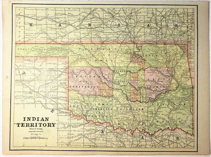
Sold2020Indian Territory 1891Title/Content of Map: Indian Territory 1891 Date Printed: 1891 Material/Medium: Paper Size: approx 10.5x14.5 inches Additional Info: Cram's Atlas of the World. Geo. F. Cram, Chicago Reserve: $20.00 SSee Sold Price
Sold2019Cuba and the Bahama IslandsTitle/Content of Map: Cuba and the Bahama Islands Date: 1889 Cartographer: CRAM, GEO. F. Publisher: CRAM, GEO. F. Size: 9Height - 12Width Map detailing the tip of FL, the Bahama islands, Cuba, JamaicaSee Sold Price
Sold2021Spain & Portugal 1891Title/Content of Map: Spain & Portugal 1891 Date Printed: 1891 Material/Medium: Paper Size: approx 11.5x14.5 inches Cram's Atlas of the World. Geo. F. Cram, Chicago Reserve: $30.00 Shipping: DomesticSee Sold Price
Sold2020Africa 1891Title/Content of Map: Africa 1891 Date Printed: 1891 Material/Medium: Paper Size: approx 21.5x14.5 inches Additional Info: Cram's Atlas of the World. Geo. F. Cram, Chicago Reserve: $25.00 Shipping: DSee Sold Price
Sold2020Italy 1891Title/Content of Map: Italy 1891 Date Printed: 1891 Material/Medium: Paper Size: approx 11x14.5 inches Additional Info: Cram's Atlas of the World. Geo. F. Cram, Chicago Reserve: $20.00 Shipping: DomeSee Sold Price
18 hrs LeftZikorn Arts & History ObjectsWest Indies, Eastern Cuba 1881 British Admiralty Nautical Map$100
1818 AuctioneersRailways and Engineering. Grover, J. W. - Estimates and Diagrams of Railway Bridges for Turnpike,£42
1818 AuctioneersCurio. Leon, Henri M. - Sheikh Haroun Abdullah: A Turkish Poet, and his Poetry. Being the Life of£22(2 bids)
17 hrs LeftPotter & Potter AuctionsMEDINA, Miruel Gomez. Pictorial Map of Mexico. 1931. USA: F...$150(1 bid)
2 days LeftAlbion AuctionsMarmocchi, F. C. 1845 Hand Col Map. Judaica - Jewish World & Israelites Camp$5
18 hrs LeftZikorn Arts & History ObjectsWest Indies, Providence, Windward, Cuba 1834 British Admiralty Map$100(1 bid)
17 hrs LeftPotter & Potter AuctionsIndianapolis / Allegheny Airlines. Circa 1970s. Silkscreen ...$200(1 bid)
17 hrs LeftPotter & Potter AuctionsBOUCHER, Lucien (1889 – 1971). Provence Breguet 763 / Air F...$300
18 hrs LeftZikorn Arts & History ObjectsEntrance to Baltic Great & Little Belt 1852 British Admiralty Map$100
18 hrs LeftZikorn Arts & History ObjectsWest Indies, Western Cuba 1879 British Admiralty Nautical Map$100
18 hrs LeftZikorn Arts & History ObjectsWest Indies Pt. Manzanilla to San Juan 1844 British Admiralty Map$100
18 hrs LeftZikorn Arts & History ObjectsWest Indies, Cape Gracias to Belize 1843 British Admiralty Map$100
3 days LeftBlackstone Valley Auctions & Estates LLCOutstanding Pre WWII Italian Air Force Officers Sword.$350(2 bids)
4 days LeftAlaska Premier Auctions & AppraisalsFr. 1075b $100 1914 Federal Reserve Note Cleveland PMG$40(4 bids)


![Cram's Rail Road & Township Map of Wisconsin. 1876: [Midwest] Pocket map: CRAM’S RAIL ROAD & TOWNSHIP MAP OF WISCONSIN. Chicago: Geo. F. Cram, 1876. 20 ¾ x 16 in., full hand coloring, original pictorial wrappers. Lower horizontal fold partly split,](https://p1.liveauctioneers.com/179/104231/53361918_1_x.jpg?height=310&quality=70&version=1495213319)
![Cram: Antique Map of Nevada: [Nevada]. Chicago: Geo. F. Cram, n.d. Coloured map. ca.1800. Approximately 20-3/4 x 13-3/4 inches image area, printed in black on cream paper, with hand colouring. Matted and shrink wrapped. Fine. The](https://p1.liveauctioneers.com/5584/107399/55057768_1_x.jpg?height=310&quality=70&version=1501794677)