2019Samuel Augustus Mitchell (1790-1868), "Plan of the CitySamuel Augustus Mitchell (1790-1868), "Plan of the City of Philadelphia and Camden, 1876, hand colored, H. - 15 1/2 in., W. - 23 1/2 in.See Sold Price
Sold2019Samuel Augustus Mitchell (1790-1868), "Plan of the CitySamuel Augustus Mitchell (1790-1868), "Plan of the City of Washington, 1860, hand colored, H. - 12 3/8 in., W. - 15 in.See Sold Price
Sold2019Samuel Augustus Mitchell (1790-1868), "Plan of NewSamuel Augustus Mitchell (1790-1868), "Plan of New York," 1866, Atlas, H.- 15 3/4 in., W.- 12 3/8 in.See Sold Price
Sold2019Three Copies of Samuel Augustus Mitchell (1790-1868),Three Copies of Samuel Augustus Mitchell (1790-1868), "Plan of New Orleans," 1862, hand colored, H. -11 1/4 in., W. - 15 1/8 in.See Sold Price
Sold2019Samuel Augustus Mitchell (1790-1868), "Plan ofSamuel Augustus Mitchell (1790-1868), "Plan of Chicago/Vicinity and Springfield en verso," 1877, H. - 15 in., W. -12 in.See Sold Price
Sold2019Samuel Augustus Mitchell (1790-1868), "Plan of NewSamuel Augustus Mitchell (1790-1868), "Plan of New Orleans," 1884, hand colored, H.-11 1/2 in., W.- 15 1/8 in.See Sold Price
Sold2019Samuel Augustus Mitchell (1790-1868), " Plan of NewSamuel Augustus Mitchell (1790-1868), " Plan of New Orleans," 1870, hand colored, H.-12 1/2 in., W.-15 1/4 in.See Sold Price
Sold2019Two Copies of Samuel Augustus Mitchell (1790-1868),Two Copies of Samuel Augustus Mitchell (1790-1868), "Plan of New Orleans," 1867, hand colored, H. -11 3/4 in., W. - 15 1/8 in.See Sold Price
Sold2019Samuel Augustus Mitchell (1790-1868), "Plan of NewSamuel Augustus Mitchell (1790-1868), "Plan of New Orleans", 1876, H. -11 1/2 in., W. - 15 1/8 in.See Sold Price
Sold2019Samuel Augustus Mitchell (1790-1868), "Plan of NewSamuel Augustus Mitchell (1790-1868), "Plan of New Orleans," 1872, hand colored, H. -11 3/4 in., W. - 15 1/8 in.See Sold Price
Sold2019Samuel Augustus Mitchell (1790-1868), "Plan of NewSamuel Augustus Mitchell (1790-1868), "Plan of New Orleans ," 1877, hand colored, H.-11 1/2 in., W.-15 1/8 in.See Sold Price
Sold2019Samuel Augustus Mitchell (1790-1868), "Plan ofSamuel Augustus Mitchell (1790-1868), "Plan of Philadelphia," 1866, H. - 12 1/8 in., W. -15 1/8 in.See Sold Price
Sold2019Three Maps by Samuel Augustus Mitchell (1790-1868), "Three Maps by Samuel Augustus Mitchell (1790-1868), " County Maps of Arkansas, Louisiana and Mississippi, Verso with Florida, and a Plan of New Orleans" 1882, hand colored, on two pages, H.-24 in., W.See Sold Price
Sold2019Two Copies of Samuel Augustus Mitchell (1790-1868),Two Copies of Samuel Augustus Mitchell (1790-1868), "Northern Portion of New York City and Brooklyn County," 1880, hand colored, H.-15 1/4 in., W.- 24 1/4 in. (2 Pcs.)See Sold Price
Sold2019Samuel Augustus Mitchell (1790-1868), "County Map ofSamuel Augustus Mitchell (1790-1868), "County Map of the States of Georgia and Alabama," 1860, H.- 12 1/4 in., W.- 15 3/8 in.See Sold Price
Sold2019Two Maps by Samuel Augustus Mitchell (1790-1868), "MapTwo Maps by Samuel Augustus Mitchell (1790-1868), "Map of North America," No. 4, 1852, hand colored, H. -11 1/2 in., W. - 9 1/8 in. (2 Pcs.)See Sold Price
Sold2019Samuel Augustus Mitchell (1790-1868), "Map of the StateSamuel Augustus Mitchell (1790-1868), "Map of the State of Texas," 1852, No. 13, hand colored, H. -9 in., W. - 15 3/8 in.See Sold Price
Sold2019Samuel Augustus Mitchell (1790-1868), "County Map ofSamuel Augustus Mitchell (1790-1868), "County Map of Scotland and Ireland," 1852, hand colored, H.-11 5/8 in., W.- 9 1/4 in.See Sold Price
Sold2019Two Maps by Samuel Augustus Mitchell (1790-1868),Two Maps by Samuel Augustus Mitchell (1790-1868), consisting of "Western Hemisphere", 1874, hand colored, H. -15 1/4 in., W. - 11 3/4 in.; together with "Eastern Hemisphere", 1884, hand colored, H. -1See Sold Price
Sold2019Samuel Augustus Mitchell (1790-1868), "Map of NorthSamuel Augustus Mitchell (1790-1868), "Map of North America," 1852, H. - 11 1/2 in., W. - 9 in.See Sold Price
Sold2019Samuel Augustus Mitchell (1790-1868), "Oregon,Samuel Augustus Mitchell (1790-1868), "Oregon, Washington, Idaho and Part of Montana," 1866, hand colored, H.-12 3/8 in., W.- 15 1/2 in.See Sold Price
Sold2019Samuel Augustus Mitchell (1790-1868), "County Map ofSamuel Augustus Mitchell (1790-1868), "County Map of the State of Illinois," 1861, hand colored, H.-15 1/4 in., W.- 12 3/8in.See Sold Price
Sold2019Two Copies of Samuel Augustus Mitchell (1790-1868),Two Copies of Samuel Augustus Mitchell (1790-1868), "Map of the United States," 1877, H. - 11 1/2 in., W. -15 in. (2 Pcs.)See Sold Price
Sold2019Samuel Augustus Mitchell (1790-1868), "County Map ofSamuel Augustus Mitchell (1790-1868), "County Map of Florida," 1867, Atlas, with an inset of Mobile, H.- 12 in., W.- 12 3/8 in.See Sold Price
Jun 14DuMouchellesWilliam H. Gamble (American, B. 1863) Hand Colored Engraving, Ca. 1863, "County Map of Michigan And$50(1 bid)
Jun 08Simpson Galleries, LLC.J.H. Young (1792-1870) AN AMERICAN FEDERAL PERIOD MAP, "Mitchell's Travellers Guide Through the$500
Jun 18DOYLE Auctioneers & AppraisersA very long panorama showing the funeral procession of the Duke of Wellington$250
Jun 08Early American History Auctions1837 Collection of Four Kalamazoo, Michigan Stampless Descriptive TRAVEL LETTERS by Nathaniel Marsh$50
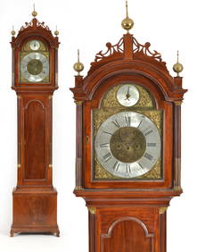
6 days LeftTremont AuctionsSamuel Mulliken mahogany tall case clock with composite brass dial, circa 1790. The Chippendale case$1,200
Jun 07Freeman's | HindmanCLEMENS, Samuel Langhorne ("Mark Twain"). Cabinet card photograph of Mark Twain. 1905. INSCRIBED BY$3,000
2 days LeftJasper521874 Holmes Plan of New York's Upper East Side -- Map of the Common Lands from 76th to 93rd Street$750
3 days LeftForum AuctionsMining.- Christy (Prof. Samuel Benedict) Quicksilver-reduction at New Almaden, California : a paper£500
Jun 08Simpson Galleries, LLC.A TSAR NICHOLAS II (1868-1918) CLOISSONÉ ENAMELED SILVER COCKEREL KOVSH VESSEL, BY PAVEL AKIMOV$4,000