Sold2023S AMERICA. Bolivia-Paraguay Gran Chaco border dispute. Chile Argentina 1920 mapTitle: S AMERICA. Bolivia-Paraguay Gran Chaco border dispute. Chile Argentina 1920 map Description: South America ( Section III ); Inset Falkland Islands' by Harmsworth (1920). Vintage colour map, 34.See Sold Price
Sold2023SOUTH AMERICA Brazil Argentina Chile Bolivia etc 1907 old antique map chartTitle: SOUTH AMERICA Brazil Argentina Chile Bolivia etc 1907 old antique map chart Description: South America' by Unsigned (1907). Colour antique map, 31.0 x 23.5cm, 12.25 x 9.25 inches Product InformSee Sold Price
Sold20222 ANTIQUE MAPS SOUTH AMERICA1- 1830 Huntington Map South America Brazil Bolivia Peru Argentina Colombia Chile 11"x8 3/4". 2- Carte de la Partie Meridionale du Bresil c. 1780. 15"x9 3/4".See Sold Price
Sold2023Chile, Argentina, Paraguay and Uruguay. South America. RAND MCNALLY 1906 mapTitle: Chile, Argentina, Paraguay and Uruguay. South America. RAND MCNALLY 1906 map Description: Argentine republic, Paraguay, Uruguay and chile, inside map southern portion of Chile and Argentine RepSee Sold Price
Sold2023SOUTH AMERICA. Shows ignored 1897 Paraguay/Bolivia border. JOHNSTON 1915 mapTitle: SOUTH AMERICA. Shows ignored 1897 Paraguay/Bolivia border. JOHNSTON 1915 map Description: South America (Southern Sheet)' by W. & A.K. Johnston, Limited, Edinburgh & London (1915). Antique coloSee Sold Price
Sold2020Blackie & Weller 1882 Lot 7 Maps of South America etcIncl South America, Venezuela/Colombia, Brazil, Peru/Bolivia, and Argentina/Chile. Also North Atlantic and Pacific Ocean. Lithograph Maps Published 1882 by Blackie & Son, London for "The ComprehensiveSee Sold Price
Sold2023South America, Southern. Argentina Chile Uruguay Brazil Paraguay. TIMES 1900 mapTitle: South America, Southern. Argentina Chile Uruguay Brazil Paraguay. TIMES 1900 map Description: South America, Southern sheet' by The Times (1900). Antique colour atlas map, 54.0 x 41.5cm, 21.25See Sold Price
Sold2023NW SOUTH AMERICA. Colombia Venezuela Ecuador Peru Bolivia Brazil. Lima 1907 mapTitle: NW SOUTH AMERICA. Colombia Venezuela Ecuador Peru Bolivia Brazil. Lima 1907 map Description: Colombia, Venezuela, British & Dutch Guiana, Ecuador, Peru, Chile, Bolivia, Paraguay, Argentine RepuSee Sold Price
Sold2023SOUTH AMERICA NW. Colombia Venezuela Ecuador Peru Bolivia Brazil. Lima 1907 mapTitle: SOUTH AMERICA NW. Colombia Venezuela Ecuador Peru Bolivia Brazil. Lima 1907 map Description: Colombia, Venezuela, British & Dutch Guiana, Ecuador, Peru, Chile, Bolivia, Paraguay, Argentine RepuSee Sold Price
Sold2022South America A-Z Accumulation Mint/UsedA mint and used A-Z South America accumulation from Argentina, Brazil, Ecuador, Columbia, Bolivia, Domninican Republic, Chile, Guatemala, Paraguay, Venezuela and Cuba, containing many early issues thrSee Sold Price
Sold2023AMAZONIA & ANDEAN STATES Colombia Venezuela Ecuador Peru Bolivia Brazil 1907 mapTitle: AMAZONIA & ANDEAN STATES Colombia Venezuela Ecuador Peru Bolivia Brazil 1907 map Description: Colombia, Venezuela, British & Dutch Guiana, Ecuador, Peru, Chile, Bolivia, Paraguay, Argentine RepSee Sold Price
Sold2023Argentine Republic, Chile, Paraguay & Uruguay. South America. STANFORD 1904 mapTitle: Argentine Republic, Chile, Paraguay & Uruguay. South America. STANFORD 1904 map Description: The Argentine Republic, Chile, Paraguay and Uruguay' by Stanford's Geographical Establishment (1904)See Sold Price
Sold2022Mapuche Stone Mask - Fine ExamplePre-Columbian, South America, Argentina or Chile, Mapuche Culture, ca. 1200 to 1700 CE. If ever there was a mask that captured the element of surprise, this one is it! A remarkably rare mask, finely cSee Sold Price
Sold2022La Aguada / Mapuche Stone Grinding Table w/ SerpentsPre-Columbian, South America, Argentina and Chile, late La Aguada to Mapuche culture, ca. 1000 to 1500 CE. A rare grinding table carved from dark brown-gray stone of a rectangular form with a stable bSee Sold Price
Sold2018Mapuche Stone Maskette - Astonished ExpressionPre-Columbian, South America, Argentina or Chile, Mapuche Culture, ca. 1200 to 1700 CE. If ever there was a mask that captured the element of surprise, this one just might be it. A very rare, finely cSee Sold Price
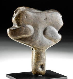
Sold202113th C. Mapuche Shaman's Stone Clava / ScepterPre-Columbian, South America, Argentina or Chile, Mapuche culture, ca. 1200 to 1700 CE. A hand-carved stone ceremonial scepter known as a clava that was suspended from the wrist of a shaman via a knotSee Sold Price
Sold2022Argentinian La Aguada Sandstone Vessel w/ LizardPre-Columbian, South America, Argentina and Chile, late La Aguada culture, ca. 1000 CE. A rare hand-carved sandstone vessel with a circular base, concave body, and round flaring rim extending wider thSee Sold Price
Sold2022Dudley Sea Chart of ArgentinaDUDLEY, Sir Robert (1574-1649). [Argentina] Carta particolare della costa di America Australe che comincia al C. di Matas sin al C. di Galegos. Engraved map. Florence, 1646. 20 7/8" x 16 1/8" sheet. SSee Sold Price
Sold2018South America.- Chile.- Spanish School (19th century) ASouth America.- Chile.- Spanish School (19th century) A group of 22 costume and character studies from Chile and its environs, including tradesmen, men with fireworks and other regional costume studieSee Sold Price
Sold2024Spanish North America, southern part by John Thomson. Central America 1830 mapTITLE/CONTENT OF MAP: 'Spanish North America, southern part' DATE PRINTED: 1830 IMAGE SIZE: Approx 53.0 x 66.0cm, 21 x 26 inches (Large); Please note that this is a folding map. TYPE: Antique early 19See Sold Price
Sold2020Laurie & Whittle Map of AmericaLAURIE & WHITTLE (Late 18th Century)The United States of America...Engraved map with original hand color in full.London: Laurie & Whittle, 1794.20 1/4" x 22 1/2" sheet.The first British map to show thSee Sold Price
Sold2020Speed's carte-a-figures map of America, California anHeading: Author: Speed, John Title: America, with those known parts in that unknowne worlde both people and manner of buildings Described and inlarged by I.S. Ano. 1626 Place Published: London PublisSee Sold Price
Sold2017America, Rare Early Map of the Americas"America", Rare Early Map of the Americas by Jodocus Hondius (Flemish/Dutch, 1563-1612) for a French edition of Mercator's Atlas, North and South America, hand-colored copper engraved map, published ASee Sold Price
Sold2024John Bowles (British 1709 - 1779)John Bowles (British 1709 - 1779) "A New and Exact Map of America Laid Down from the Latest Observations and Discoveries", circa 1750 Two sheet map engraving of the "Representation of the Customs andSee Sold Price
Jul 11Dan Morphy AuctionsRARE INDEPENDENT GASOLINE & MOTOR OIL FRAMED GRAPHIC HIGHWAY MAP OF ILLINOIS.$125
Jun 07Freeman's | Hindman[MAP]. TODESCHI, Pietro. [Nova et Acurata Totius Americae Tabula auct. G.I. Blaeu] America quarta$5,000
289 Lots AwayCottone AuctionsSilver-Plated Art Deco Tea Service with Inlaid Malachite Handles and Border$250(5 bids)
2 days LeftBlack Hills Curio Companyc 1890-1910 Native American Northern Plains Beaded Bag sinew sewn elk dreamer$125
BonhamsFABRIS (SALVATOR) De lo schermo overo scienza d'arme, 2 parts in 1 vol., FIRST EDITION, Copenhag...£1,800
Jun 15Crescent City Auction GalleryHarris G. Strong (American, 1920-2006), "Pair of Ceramic Bulls Facing Off," H.- 12 1/4 in., W.- 18$325
192 Lots AwayCottone AuctionsG. H. Laurent (French, 1880-1940, active circa 1920) Two-Toned Art Deco Stylized Heron$550(3 bids)
Jun 22Check the Oil Promotions, LLCRare Unrestored 1920 Wayne Model 11 Air Meter & Water Station$1,450(3 bids)
Featured3 days LeftGold Coast AuctioneersJohn Fenton ( America 1912-1977) "Death of a Bullfighter" Oil on Canvas$325(3 bids)
3 days LeftTaylor & Harris11 Minton England for Tiffany & Co Gilt Porcelain Dessert Plates c 1920$1,100(3 bids)
5 days LeftHeritage Auctions70211: A Northwest Coast Totem Pole c. 1920 wood, pai$1,500


![Dudley Sea Chart of Argentina: DUDLEY, Sir Robert (1574-1649). [Argentina] Carta particolare della costa di America Australe che comincia al C. di Matas sin al C. di Galegos. Engraved map. Florence, 1646. 20 7/8" x 16 1/8" sheet. S](https://p1.liveauctioneers.com/1968/250616/130196501_1_x.jpg?height=310&quality=70&version=1654190895)


![[MAP]. TODESCHI, Pietro. [Nova et Acurata Totius Americae Tabula auct. G.I. Blaeu] America quarta (1 of 1)](https://p1.liveauctioneers.com/197/329395/177650542_1_x.jpg?height=282&quality=70&version=1715364962)


