Sold2019Two Maps by Rigobert Bonne (1727-1794, Paris),Two Maps by Rigobert Bonne (1727-1794, Paris), "Amerique Septentrionle (N. America)," 1787, matted and mounted, hand colored; together with "Les Petites Antilles ou les Iles du Vent," Petitsem- H. - 1See Sold Price
Sold2023Amerique Meridionale. Antique map of South America. BONNE 1787 oldTitle: Amerique Meridionale. Antique map of South America. BONNE 1787 old Description: Amerique Meridionale [South America] by Rigobert Bonne (1787). Antique 18th century copperplate map, 36.0 x 25.0cSee Sold Price
Sold20211787 Bonne Map of Barbary AfricaCarte De La Partie Septentrionale D'Afrique, ou de la Barbarie…, by Rigobert Bonne, published in Paris in 1787. Folding map, Very Good. Measures 15.5 x 10". Reserve: $20.00 Shipping: Domestic: Flat-See Sold Price
Sold2021"Carte du Chili" Engraved Map by Rigobert BonneRigobert Bonne (French, 1727-1795). A hand colored engraved map on paper, depicting Chile. 13" x 8.5" (sight), 21" x 16.5" (framed).See Sold Price
Sold2020Bonne Map of Louisiana and Florida 1780Rigobert Bonne (1727-1795), engraved by Peter Andre, "Carte de la Louisiane, et de la Floride," Paris, ca. 1780. This hand colored map depicts the southeastern United States, extending from West VirgiSee Sold Price
Sold2016Lower Rhine (Germany). Jean-Baptiste Louis Clouet.Cercle du Bas Rhin. Geographe Moderne Maker: Clouet, Jean-Baptiste Louis. Origin: Paris, 1787. Medium: Original engraving hand-colored at publication. Sheet size: 19 3/4 x 26 3/4 in. No Reserve: ThisSee Sold Price
Sold2018Bonne: Antique Map of Asia, 1787Item: Map of Asia 1787 Bonne Etching On Copper Very beautiful map of Asia Author: Bonne Rigobert (1727-1794) Atlas: Atlas de toutes parties connues du globe terrestre... Date: 1787 Technique: etchingSee Sold Price
Sold2022Bonne, Rigobert - Newfoundland, Acadia and Nova Scotia mapBonne, Rigobert (1727-1794) Newfoundland, Acadia and Nova Scotia map Description: Undated, hand colored, titled: L'isle de Terre Neuve, l'Acadie ou la Nouvelle Ecosse, l'Isle St Jean et la partie orieSee Sold Price
Sold2018Bonne: Antique Map of North America, 1787Very beautiful map of North America Author: Bonne, Rigobert (1727-1794). Atlas: Atlas de toutes parties connues du globe terrestre... Date: 1787 Technique: etching on copper Leaf Dimension: 38x30 cm (See Sold Price
Sold2023(NORTH AMERICA.) Group of 15 small-scale eighteenth and nineteenth century engraved maps.(NORTH AMERICA.) Group of 15 small-scale eighteenth and nineteenth century engraved maps. Vp, vd - Rigobert Bonne. Amerique Septentrionale. 10x14½ inches; hand-colored in outline. Paris, circa 17See Sold Price
Sold2021Rigobert Bonne Maps of Mexico, 18th CenturyA nicely framed and matted pair of maps depicting "Le Nouveau Mexique" and "De L'Ancien Mexique", double matted within frame, each by Rigobert Bonne and engraved by Dien, with original coloring. EachSee Sold Price
Sold2018Seutter: Antique Map of Brandenburg & Pomerania, 1740Title/Content of Map: Brandenburg & Pomerania region of Germany & Poland Date Printed: c1740 Cartographer: Matthaus Seutter Material/Medium: Paper Size: 19 1/2" x 23 3/4" Original hand colored copperpSee Sold Price
Sold2022MAP, Southern Alaska, BonneSouthern Alaska. Rigobert Bonne, Carte de la Riviere de Cook dans la Partie N.O. de l'Amerique, from Atlas Encyclopedique, 1787 (circa). Black & White. This handsome map shows Capt. Cook's discoveriesSee Sold Price
Sold2018Bonne: Antique Map of Tartary China Korea Japan, 1787Item: Map of Tartary China Korea Japan 1787 Bonne Etching On Copper Very beautiful map of Tartary, China, Korea and Japan Author: Bonne Rigobert (1727-1794) Atlas: Atlas de toutes parties connues du gSee Sold Price
Sold2021RIGOBERT BONNE Map Ancient World c1840This map is in very good condition, folded as published, hand colored, published ca1840, measures 15" x 10"See Sold Price
Sold2019R. Wilkinson Antique Hand Colored Map of SwabiaDescription: R. Wilkinson antique, hand colored map of Swabia. Swabia was a medieval Duchy in southwest Germany, that also included part of Poland. Possibly circa 1822 as indicated by original owner.See Sold Price
Sold2022Original Antique Map -Pommern Provinz - Map of Bornholm Island Baltic SeaAntique outline hand colored map from edition of Meyer’s world atlas, edited by Ludwig Ravenstein, published by Bibliographic Institute in 1872. Technique: Engraving. Place: Leipzig, Germany. SSee Sold Price
Sold2022Original Antique Map - Mecklenburg-Schwerin - Map of Northern GermanyAntique outline hand colored map from edition of Meyer’s world atlas, edited by Ludwig Ravenstein, published by Bibliographic Institute in 1872. Technique: Engraving. Place: Leipzig, Germany. SSee Sold Price
Sold2022Original Antique Map -Bremen Oldenburg - Map of Bremen OldenburgAntique outline hand colored map from edition of Meyer’s world atlas, edited by Ludwig Ravenstein, published by Bibliographic Institute in 1872. Technique: Engraving. Place: Leipzig, Germany. SSee Sold Price
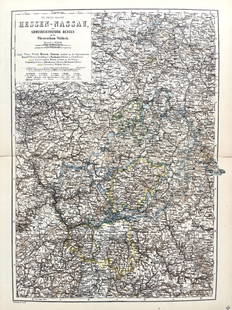
Sold2022Original Antique Map -Hessen Nassau - Map of Furstenthum WaldeckAntique outline hand colored map from edition of Meyer’s world atlas, edited by Ludwig Ravenstein, published by Bibliographic Institute in 1872. Technique: Engraving. Place: Leipzig, Germany. SSee Sold Price
Sold2022Original Antique Map - Konicreich Bohmen - Map of Bohmen - Prague - CarlsbadAntique outline hand colored map from edition of Meyer’s world atlas, edited by Ludwig Ravenstein, published by Bibliographic Institute in 1872. Technique: Engraving. Place: Leipzig, Germany. SSee Sold Price
Sold2017Bonne: Map of Virgin Islands/Lesser Antilles, 1780Map: Supplement pour les Isles Antilles Cartographer: Rigobert Bonne Place & Date: Paris / 1780s Size: 8 1/2" x 13" Condition: b&w with colored border; overall age toning; minor browning, fraying andSee Sold Price
Sold2024Rigobert Bonne - Map of Asia MinorMap "Carte Moderne De L´Asie Mineurne" by M. Bonne, 1781.See Sold Price
Sold20161666 Original Hand Colored Map of Virginiaapprox 21" X 17"...... Pas Caerte van Nieu Nederlandt en de Engelsche Virginies, van Cabo Cod tot Cabo Canrick. (Chart of New Netherland and the English Virginias from Cape Cod to Cape Canrick [i.e. HSee Sold Price
Jun 08Early American History Auctionsc 1730 Hand-Colored Colonial Era Map of the Americas, California shown as an Island, Matted + Framed$500(1 bid)
Jun 08Early American History Auctions1836 Hand-Colored Map, Country Twenty Five Miles Round The City Of New-York Published by D.S. Stone$260
5 days LeftJasper52Large Antique French map GERMAN EMPIRE 1792 colored by POIRSON engraver Basset$170
Jun 09Worthington GalleriesFirst Edition Hand-colored Map THE NORTH RIDING OF YORKSHIRE by Robert Morden$50
Jun 15Riverfront AuctionsC. 1730 Map of North Rhine-Westphalia, Germany after N. Sanson by Covens and Mortier$5
5 days LeftJasper521770 French engraving map of Bonne,Rigobert Arabie. Mer Rouge et Golfe Persique$95
42 mins LeftPotter & Potter AuctionsREID, W. Hamilton (??-1826). Memoirs of the Public and Priv...$80


![Amerique Meridionale. Antique map of South America. BONNE 1787 old: Title: Amerique Meridionale. Antique map of South America. BONNE 1787 old Description: Amerique Meridionale [South America] by Rigobert Bonne (1787). Antique 18th century copperplate map, 36.0 x 25.0c](https://p1.liveauctioneers.com/5584/299901/159842150_1_x.jpg?height=310&quality=70&version=1693338270)