Sold20211787 Bonne Map of Barbary AfricaCarte De La Partie Septentrionale D'Afrique, ou de la Barbarie…, by Rigobert Bonne, published in Paris in 1787. Folding map, Very Good. Measures 15.5 x 10". Reserve: $20.00 Shipping: Domestic: Flat-See Sold Price
Sold2016Jean-Baptiste Louis Clouet: North Africa 1787Map: Barbary Coast, North Africa Maker: Jean-Baptiste Louis Clouet From Géographie Moderne Origin: Paris Date: 1787 Medium: Engraving hand-colored at publication Sheet Size: 19.75 x 26.75 inches No RSee Sold Price
Sold20221787 Bonne Map of the Canary Islands -- Isles CanariesTitle: 1787 Bonne Map of the Canary Islands -- Isles Canaries Cartographer: R Bonne Year / Place: 1787, Paris Map Dimension (in.): 9.2 X 13.6 in. This is a very nice map of the Canary Islands with a sSee Sold Price
Sold20211770 Bonne Map of Africa's Guinea Coast to Congo --Title: 1770 Bonne Map of Africa's Guinea Coast to Congo -- Carte de la Haute et de la Basse Guinee Depuis la Riviere de Sierra Leona jusqu'au Cap Negro Cartographer: R Bonne Year / Place: 1770 c., ParSee Sold Price
Sold20201782 Bonne Map of Eastern Africa and Madagascar --Title/Content of Map: 1782 Bonne Map of Eastern Africa and Madagascar -- Partie De La Cote Orientale D'Afrique avec l'Isle de Madgascar et le Cartes particulieres des Isles de France et de Bourbon . .See Sold Price
Sold2017Bonne: Antique Map of Africa showing Trade Wings, 1780Title/Content of Map: 'Afrique' A map of Africa, showing the trade winds Date Printed: 1780 Image Size: Approx 23.0 x 34.0cm, 9 x 13.25 inches (Large); Please note that this is a folding map. Type: AnSee Sold Price
Sold2024Bonne & Desmarest - Map of AfricaThis fine map engraving is from Rigobert Bonne and Nicolas Desmarest's Atlas encyclop?dique, contenant la g?ographie ancienne, et quelques cartes sur la g?ographie du moyen age, la g?ographie moderneSee Sold Price
Sold20221770 Bonne Map of Northern Africa -- Carte De La Partie Septentionale D'Afrique, ou De La Barbarie;Title: 1770 Bonne Map of Northern Africa -- Carte De La Partie Septentionale D'Afrique, ou De La Barbarie; Contenant Les Royaumes De Tripoli, De Tunis, D'Alger, De Fez Et De Maroc Cartographer: R BonnSee Sold Price
Sold20201787 Large Folding Map of AfricaAfrica Drawn from the latest and best Authorities, published at London by Harrison and Co., 1787. Fine, measures 19.5 x 16". Reserve: $30.00 Shipping: Domestic: Flat-rate of $5.00 to anywhere within tSee Sold Price
Sold20241837. Map of Barbary Coast. Northwest Africa. Morocco, Algeria, Libya and Tunisia. By A. PerrotTitle: 1837. Map of Barbary Coast. Northwest Africa. Morocco, Algeria, Libya and Tunisia. By A. Perrot Date/Period: 1837 Materials: Hand-colored steel engraving Size: 7 x 10 3/4” This is a map oSee Sold Price
Sold2018Sayer: Antique Map of Africa, 1787Title/Content of Map: 1787 Sayer Map of Africa -- Africa with All its States, Kingdoms, Republics, Regions, Islands &c. Improved and Inlarged from D'Anville's Map: To which have been Added a ParticulaSee Sold Price
Sold2018Bonne: Antique Map of Tartary China Korea Japan, 1787Item: Map of Tartary China Korea Japan 1787 Bonne Etching On Copper Very beautiful map of Tartary, China, Korea and Japan Author: Bonne Rigobert (1727-1794) Atlas: Atlas de toutes parties connues du gSee Sold Price
Sold2018Bonne: Antique Map of Asia, 1787Item: Map of Asia 1787 Bonne Etching On Copper Very beautiful map of Asia Author: Bonne Rigobert (1727-1794) Atlas: Atlas de toutes parties connues du globe terrestre... Date: 1787 Technique: etchingSee Sold Price
Sold2023Amerique Meridionale. Antique map of South America. BONNE 1787 oldTitle: Amerique Meridionale. Antique map of South America. BONNE 1787 old Description: Amerique Meridionale [South America] by Rigobert Bonne (1787). Antique 18th century copperplate map, 36.0 x 25.0cSee Sold Price
Sold2023NORTH AFRICA BARBARY. Tripoli Libya Egypt coast Alexandria Tobruk. SDUK 1874 mapTITLE/CONTENT OF MAP: 'NORTH AFRICA OR BARBARY, V., PARTS OF TRIPOLI AND EGYPT' DATE PRINTED: 1874 IMAGE SIZE: Approx 34.0 x 42.5cm, 13.25 x 16.75 inches (Large) TYPE: Antique steel engraved map withSee Sold Price
Sold2023French map of Africa published by Bonne 1780Rigobert Bonne (6 October 1727 – 2 September 1794) work represents an important step in the evolution of the cartographic ideology away from the decorative work of the 17th and early 18th centuSee Sold Price
Sold2019Africa.- De L'Isle (Guillaume) Carte de la Barbarie deAfrica.- De L'Isle (Guillaume) Carte de la Barbarie de la Nigritie et de la Guinée, map of western Africa from Barbary, Nigeria, and Guinea to below the equator, with numerous tent encampments deSee Sold Price
Sold2019SDUK: North Africa in 5 sheetsMap Title: North Africa or Barbary I – V Cartographer: Baldwin & Cradock, Society for the Diffusion of Useful Knowledge Place/Date: London / 1836/1852 Size: 15 1/4" x 12 1/2" Condition: b&w; overallSee Sold Price
Sold2018Bonne: Antique Map of North America, 1787Very beautiful map of North America Author: Bonne, Rigobert (1727-1794). Atlas: Atlas de toutes parties connues du globe terrestre... Date: 1787 Technique: etching on copper Leaf Dimension: 38x30 cm (See Sold Price
Sold20211840 SDUK Map of Morocco -- Northern Africa or BarbaryTitle: 1840 SDUK Map of Morocco -- Northern Africa or Barbary I Marocco Cartographer: SDUK Year / Place: 1840, London Map Dimension (in.): 12.6 x 15.4 in This is very nice and superbly detailed map ofSee Sold Price
Sold2017Bonne: Antique Map of Northern Polar Projection, 1787Title/Content of Map: Antique Northern Polar Projection Date Printed: 1787 Cartographer: Bonne, Rigobert Size (inches): 14 x 9 Condition: Very good. On strong chain-laid paper. A strong impression. SiSee Sold Price
Sold2017Bonne: Antique Map of the Western Hemisphere. 1787Title/Content of Map: Western Hemisphere - Antique 45 Degree Southern Oblique Projection. Mappe-Monde sur le plan Horizontal situe a 45 d. de latitude Sud. Hemisphere Occidental. Date Printed: 1787 CaSee Sold Price
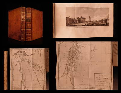
Sold20201787 1st ed Voyages in Syria & EGYPT Africa Illustrated1787 1st ed Voyages in Syria & EGYPT Africa Illustrated MAPS Sphinx 2v Volney “The best expose of Ottoman Empire at the end of the 18th-century!” (Blackmer) Constantin-François Volney, an 18th-ceSee Sold Price
Sold2022MAP, Southern Alaska, BonneSouthern Alaska. Rigobert Bonne, Carte de la Riviere de Cook dans la Partie N.O. de l'Amerique, from Atlas Encyclopedique, 1787 (circa). Black & White. This handsome map shows Capt. Cook's discoveriesSee Sold Price
4 days LeftActivity AuctionsAntique 1787 French Maritime Hydrography Map Eastern Coast United States M Bonne$150
May 22Jasper52Tartarie Chinoise, Royaume de Corée &… Japon. China Korea Japan. BONNE 1788 map$30
May 22Jasper52Tartarie Chinoise, Royaume de Corée &… Japon. China Korea Japan. BONNE 1790 map$30
20 hrs LeftJasper52Le Nord de l'Europe contenant le Danemark… Scandinavia Russia. BONNE 1780 map$35
20 hrs LeftJasper52L'Allemagne, La Boheme, et La Hongrie; avec…partie de Pologne. BONNE 1780 map$60
1 day LeftPotter & Potter AuctionsAUDIBERTI, J. Choain. Afrique Equatoriale Francaise. Paris:...$100(1 bid)
7 days LeftJasper521790 AFRICA TRAVELS Voyages dans le pays des Hottentots ILLUSTRATED antique RARE$280
3 days LeftTrillium Antique Prints & Rare BooksPtolemy & Magini, pub. 1620 - 3 Maps of part of Africa$50
May 30Forum Auctionsd'Anville (Jean Baptiste Bourguignon) [Untitled Composite Atlas with 102 map sheets], [probably£2,000


![Amerique Meridionale. Antique map of South America. BONNE 1787 old: Title: Amerique Meridionale. Antique map of South America. BONNE 1787 old Description: Amerique Meridionale [South America] by Rigobert Bonne (1787). Antique 18th century copperplate map, 36.0 x 25.0c](https://p1.liveauctioneers.com/5584/299901/159842150_1_x.jpg?height=310&quality=70&version=1693338270)


![[MAP]. ORTELIUS, Abraham. Africae Tabula Nova. 1592. (1 of 2)](https://p1.liveauctioneers.com/197/329395/177650533_1_x.jpg?height=282&quality=70&version=1715364962)


![d'Anville (Jean Baptiste Bourguignon) [Untitled Composite Atlas with 102 map sheets], [probably (1 of 3)](https://p1.liveauctioneers.com/5458/329231/177514974_1_x.jpg?height=282&quality=70&version=1715269091)


