Sold2023Rhineland region. 1790 by BonneTitle: Rhineland region. 1790 by Bonne Date/Period: 1780-1790 Materials: Copperplate engraved Size: 14 3/4” x 10 3/4” 1780-1790, published 1790 in ‘Atlas Portatif general pour swrvirSee Sold Price
Sold2023France’s famous Champagne region. 1790 by BonneTitle: France’s famous Champagne region. 1790 by Bonne Date/Period: 1780-1790 Materials: Copperplate engraved Size: 14 3/4” x 10 3/4” 1780-1790, published 1790 in ‘Atlas PortatSee Sold Price
Sold2023France’s Provence region. Marseille region. 1790 by BonneTitle: France’s Provence region. Marseille region. 1790 by Bonne Date/Period: 1780-1790 Materials: Copperplate engraved Size: 14 3/4” x 10 3/4” 1780-1790, published 1790 in 'Atlas poSee Sold Price
Sold2023Northern France, Artois, Picardy region. 1790 by BonneTitle: Northern France, Artois, Picardy region. 1790 by Bonne Date/Period: 1780-1790 Materials: Copper plate engraved Size: 14 3/4" x 10 3/4" 1780-1790, published 1790 in 'Atlas Portatif general pourSee Sold Price
Sold2023France’s eastern Normandy region. 1790 by BonneTitle: France’s eastern Normandy region. 1790 by Bonne Date/Period: 1780-1790 Materials: Copperplate engraved Size: 14 3/4” x 10 3/4” 1780-1790, published 1790 in ‘Atlas PortatSee Sold Price
Sold2023France’s eastern Normandy region. 1790 by BonneDescriptionTitle: France’s eastern Normandy region. 1790 by BonneDate/Period: 1780-1790Materials: Copper plate engravedSize: 14 3/4” x 10 3/4”1780-1790, published 1790 in ‘AtlSee Sold Price
Sold2023Germany’s Swabia region. 1790 by BonneTitle: Germany’s Swabia region. 1790 by Bonne Date/Period: 1780-1790 Materials: Copperplate engraved Size: 14 3/4” x 10 3/4” 1780-1790, published 1790 in ‘Atlas Portatif generSee Sold Price
Sold2023France’s Marche, Auvergne region. 1790 by BonneTitle: France’s Marche, Auvergne region. 1790 by Bonne Date/Period: 1780-1790 Materials: Copperplate engraved Size: 14 3/4” x 10 3/4” 1780-1790, published 1790 in 'Atlas portatif pouSee Sold Price
Sold2023France’s Marche, Auvergne region. 1790 by BonneDescriptionTitle: France’s Marche, Auvergne region. 1790 by BonneDate/Period: 1780-1790Materials: Copperplate engravedSize: 14 3/4” x 10 3/4”1780-1790, published 1790 in 'Atlas portSee Sold Price
Sold2023France’s Bourgogne and Lyon region. Alps. 1790 by BonneTitle: France’s Bourgogne and Lyon region. Alps. 1790 by Bonne Date/Period: 1780-1790 Materials: Copperplate engraved Size: 14 3/4” x 10 3/4” 1780-1790, published 1790 in ‘AtlaSee Sold Price
Sold2023Germany’s eastern Brandenburg region now Poland. 1790 by BonneTitle: Germany's eastern Brandenburg region now Poland. 1790 by Bonne Date/Period: 1780-1790 Materials: Copper plate engraved Size: 14 3/4" x 10 3/4" 1780-1790, published 1790 in 'Atlas Portatif generSee Sold Price
Sold2023Worlds equatorial regions wind currents. 1790 by BonneTitle: Worlds equatorial regions wind currents. 1790 by Bonne Date/Period: 1790 Materials: Copperplate engraved Size: 14 3/4” x 10 3/4” 1780-1790, published 1790 in "Atlas Portatif generalSee Sold Price
Sold2023France’s champagne region centering on Brie. 1790 by BonneTitle: France’s champagne region centering on Brie. 1790 by Bonne Date/Period: 1780-1790 Materials: Copperplate engraved Size: 14 3/4” x 10 3/4” 1780-1790, published 1790 in ‘ASee Sold Price
Sold2023France’s western Normandy region with the Channel Islands 1790 by BonneTitle: France’s western Normandy region with the Channel Islands 1790 by Bonne Date/Period: 1780-1790 Materials: Copper plate engraved Size: 14 3/4” x 10 3/4” 1780-1790, published 17See Sold Price
Sold20241775-1780 Upper Midwest and Great Lakes region. By Bonne & RaynalTitle: 1775-1780 Upper Midwest and Great Lakes region. By Bonne & Raynal Date/Period: 1775-1780 Materials: Copperplate engraved Size: 14 1/2” x 9 1/2 “ This vintage map, created by R. BonnSee Sold Price
Sold2023Early dated (1781) United States, 1790 by BonneTitle: Early dated (1781) United States, 1790 by Bonne Date/Period: 1790 Materials: Copper plate engraved Size: 14 3/4” x 10 3/4” Revolutionary era map already recognizes the United StatesSee Sold Price
Sold2023North America, fictional sea of the west, north west passage. 1790 by BonneTitle: North America, fictional sea of the west, north west passage. 1790 by Bonne Date/Period: 1790 Materials: Copper plate engraved Size: 14 3/4” x 10 3/4” The fictional sea of the West,See Sold Price
Sold2021Early map of the Great Lakes, Midwest region. By Bonne/Title: Early map of the Great Lakes, Midwest region. By Bonne/ Raynal. 1780 Date/Period: 1780 Materials: Copperplate engraved Size: 13 1/2 x 9 3/4 An important and detailed early map of the Great LakeSee Sold Price
Sold2022Philippines, Vietnam with Indonesia 1790 by BonneTitle: Philippines, Vietnam with Indonesia 1790 by Bonne Date/Period: 1790 Materials: Copper plate engraved Size: 14 3/4” x 10 3/4” 1780-1790, published 1790 in "Atlas Portatif general pouSee Sold Price
Sold2023Côte NO de l'Amérique & côte NE de l’Asie. Alaska & Kamchatka. BONNE 1790 mapTITLE/CONTENT OF MAP: [Cook 3e Voyage] Carte de la côte Nord-Ouest de l'Amérique et de la côte Nord-Est de l’Asie // Plan de l'Entrée de Nootka [Cook's 3rd Voyage - Map of thSee Sold Price
Sold2023Détroit de Magellan. Strait of Magellan. Chile. BONNE 1790 old antique map[Voyage des Capitaines Byron, Vallis et Carteret] Détroit de Magellan avec les Plans des principaux Ports, Bayes &c. de ce Détroit // Havre Swalow ou de l'Hirondelle // Baye du Cap Upright // BaSee Sold Price
Sold2023Ancient tribal Germany. 1790 by BonneTitle: Ancient tribal Germany. 1790 by Bonne Date/Period: 1780-1790 Materials: Copper plate engraved Size: 14 3/4” x 10 3/4” 1780-1790, published 1790 in ‘Atlas Portatif general pourSee Sold Price
Sold2023L’Isle de St Domingue et… Porto-Rico. Hispaniola & Puerto Rico. BONNE 1790 mapL’Isle de St Domingue et celle de Porto-Rico [The islands of Hispaniola and Puerto Rico] by Rigobert Bonne (1790). Antique 18th century copperplate map, 24.5 x 36.0cm, 9.5 x 14.25 inches; PleaseSee Sold Price
Sold2023Large Poland and Lithuania Kingdom. 1790 by BonneTitle: Large Poland and Lithuania Kingdom. 1790 by Bonne Date/Period: 1780-1790 Materials: Copper plate engraved Size: 14 3/4” x 10 3/4” 1780-1790, published 1790 in ‘Atlas PortatifSee Sold Price
Jun 05Jasper52Le Canal de Mosambique, l'Isle de Madagascar… Mozambique. Africa. BONNE 1790 map$20
Jun 05Jasper52États du Roi de Maroc… d’Alger, Tunis & Tripoli. North Africa. BONNE 1790 map$20
Jun 05Jasper52La Basse-Guinée… Loango, Congo, AngoIa & Benguela Southern Africa BONNE 1790 map$20
23 hrs LeftJasper52Détroit de Magellan. Strait of Magellan. Chile. BONNE 1790 old antique map$30
7 days LeftJasper521775-1780 North West Africa with Cape Verde and Canary Islands. By Bonne and Raynal$20
7 days LeftJasper521775-1780 Uruguay, Northern Argentina, Southern Brazil, and Rio de Janeiro. By Bonne & Raynal$25
4 days LeftTrillium Antique Prints & Rare BooksDobson - Map of the World with Chart of Torrid Zone or Tropical Regions of the World$50
84 Lots AwayHermann Historica GmbHA Chinese carved grey limestone head of Bodhisattva, probably Shandong region, circa 6th centurySee Sold Price
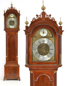
5 days LeftTremont AuctionsSamuel Mulliken mahogany tall case clock with composite brass dial, circa 1790. The Chippendale case$1,200
5 days LeftCarlsen Gallery, Inc.C. 1790 HEPPLEWHITE INLAID SIDEBOARD W/ SPADE FEET (FOOT RESTORATION) (43 1/2" TALL X 73 3/8" LONG$200(1 bid)
10 Lots AwayHermann Historica GmbHAn Ottoman gold-damascened yatagan with silver scabbard, dated 1790See Sold Price
4 days LeftNorthgate Gallery, Inc.Antique French Louis XV Style Oak and Burl Walnut Draw End Dining Table from Normandy Region of$100
7 days LeftDOYLE Auctioneers & AppraisersItalian Neoclassical Brass Inlaid Walnut Game Table Circa 1790$1,500
Jun 14DuMouchellesRigobert Bonne (French, 1727-1794) Hand Colored Engraving Ca. 18th Century, Les Etats Unis De$50
Jun 17Material CultureCentral Anatolian Kilim, Cappadocia Region, Turkey, Ca. 1800 or earlier, 4'1'' x 11'10''$2,000


![Côte NO de l'Amérique & côte NE de l’Asie. Alaska & Kamchatka. BONNE 1790 map: TITLE/CONTENT OF MAP: [Cook 3e Voyage] Carte de la côte Nord-Ouest de l'Amérique et de la côte Nord-Est de l’Asie // Plan de l'Entrée de Nootka [Cook's 3rd Voyage - Map of th](https://p1.liveauctioneers.com/5584/310511/166159558_1_x.jpg?height=310&quality=70&version=1701205563)
![Détroit de Magellan. Strait of Magellan. Chile. BONNE 1790 old antique map: [Voyage des Capitaines Byron, Vallis et Carteret] Détroit de Magellan avec les Plans des principaux Ports, Bayes &c. de ce Détroit // Havre Swalow ou de l'Hirondelle // Baye du Cap Upright // Ba](https://p1.liveauctioneers.com/5584/294908/156576972_1_x.jpg?height=310&quality=70&version=1688565030)

![L’Isle de St Domingue et… Porto-Rico. Hispaniola & Puerto Rico. BONNE 1790 map: L’Isle de St Domingue et celle de Porto-Rico [The islands of Hispaniola and Puerto Rico] by Rigobert Bonne (1790). Antique 18th century copperplate map, 24.5 x 36.0cm, 9.5 x 14.25 inches; Please](https://p1.liveauctioneers.com/5584/305600/163297718_1_x.jpg?height=310&quality=70&version=1697577828)