Sold20211864 U.S. Coast Survey Map of Washington D.C.,Approx. 23" X 40". Upper portion slight staining and minor loss as shown. Highly detailed Civil War era sea chart of part of the Potomac River, including Alexandria and Washington D.C. north to GeorgeSee Sold Price
Sold20191794 Sea Chart of South Part Sumatra 18th Century Mapa very rare 18th century antique sea chart. This is an uncolored copper plate engraving. Image measures 24\" x 32.5\". This map has been matted and is ready for framing. A stunning chart of the southeSee Sold Price
Sold202319th C. French, English Sea Charts (4pc)Four 19th C. English and French Sea Charts: (1) Chart titled, "The Port of Mochima from a Spanish printed Plan" Published 1871 J.D. Potter, London. Good condition, measures: 12" H x 8.75" W., (1) CharSee Sold Price
Sold2023Trinidad Island. Eastern Part. West Indies. ADMIRALTY sea chart 1869 (1950) mapTrinidad Island - Eastern Portion' by Bocas Del Dragon to Icacos point from the surveys by Commr. Alun Jones, R.N., and the Officers of H.M. Surveying Ship "Challenger" 1936. Eastern portion of Gulf oSee Sold Price
Sold2018Antique 1856 US Coastal Survey of Martha's VineyardTitle/Content of Map: 1856 US Coastal Survey of Martha's Vineyard amd Nantucket Area in Massachusetts -- Preliminary Chart of Part of the Sea Coast of Massachusetts from Saughkonnet River to PlymouthSee Sold Price
Sold2018Caribbean & Gulf of Mexico.- Moll (Herman) A Map of theCaribbean & Gulf of Mexico.- Moll (Herman) A Map of the West-Indies or the Islands of America in the North Sea, a large and impressively detailed chart, showing parts of Louisiana and Florida in trianSee Sold Price
Sold2023Trinidad west part Gulf of Paria West Indies ADMIRALTY sea chart 1869 (1951) mapWest Indies - Trinidad Island and Gulf of Paria' by Bocas Del Dragon to Icacos point from the surveys by Commr. Alun Jones, R.N., and the Officers of H.M. Surveying Ship "Challenger" 1936. Eastern porSee Sold Price
Sold2023Scarce sea chart of the area from Galicia to the southern part of the English Channel and Ireland,Scarce sea chart of the area from Galicia to the southern part of the English Channel and Ireland, oriented with East at the top. Includes a decorative cartouche, compass rose, sailing ships, rhumblinSee Sold Price
Sold2020Nautical Map / Sea Chart, #1212 Eastern Long IslandDescription: Nautical Map / Sea Chart, United States East Coast, Connecticut - New York, Long Island Sound, Eastern Part, 12th edition feb 10 / 69 ; all measurements are approximate; Folded; ShippingSee Sold Price
Sold2022HARVEY R. PETERSON (CONTEMPORARY NORTHPORT, MAINE)"Penobscot Man", a Sea Captain with Binoculars, carved and painted wood, clothed in old sea charts, having three compasses (one inset in his belly, one in his plinth and a small one in the drawer at tSee Sold Price
Sold2021Carte Particuliaire de la Coste D'or, 1750Carte Particuliaire de la Coste D'or, 1750A large color sea chart of the coast of Ghana, by Jacques-Nicolas Bellin as a part of his work on the large atlas, Hydrographie Francais23.5 x 17.75 inchesSee Sold Price
Sold2018Framed Print Repro Of N. Currier Ship LithographFramed Print Reproduction Of N. Currier Ship Lithograph. Nautical Prints. A framed and matted print depicting a three masted ship at sea titled “Homeward Bound”. Beneath image in print reads, EnteSee Sold Price
Sold2023JOHN MARIN 'BOAT AND SEA' LITHOGRAPHJohn Marin offset lithograph on laid paper. Titled 'Boat and Sea, Deer Isle, Maine'. Signed and dated 1927 in the plate lower right. Measures 13 3/8" x 10 1/2" + 2 3/4" mat & frame.See Sold Price
Sold2019Leo John Meissner Woodcut [AAA, Sea Gulls]Leo John Meissner (Maine, New York Michigan 1895 - 1977) woodcut. Copyright, signed and dated (1936) in plate lower left. Work titled 'Sea Gulls'. Measures 8-in. x 10-in. image size, 13-in. x 18-in. sSee Sold Price
Sold2022VERN BROE BEACH SCENE PAINTINGImpressionist oil painting on board depicting children on the beach, titled HUNTING SEA SHELLS verso, signed Vern Broe. Also bears his estate stamp from Richmond Maine. 11 x 14, framed 14.5 x 18 incheSee Sold Price
Sold2024LARGE REPRO 19TH C. WHALING CHART; SOUTH CHINA SEAReproduction of an antique map. Two sheets, joined. Dimensions: (Frame) H 55.5" x W 45.5" Condition: Not examined out of frame. Intentionally antiqued; with spots of soiling, creases, a few tears andSee Sold Price
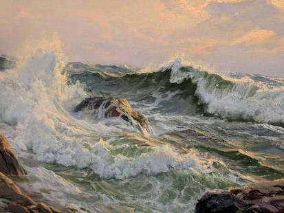
Sold2017Charles Vickery SUNSET AND SURGING SEA OIL PaintingImpressively sized, signed Charles Vickery, Oil on Canvas . Framed Russel Burton Gallery Chicago .Seascape titled SUNSET AND SURGING SEA of the Maine coastline, that illuminates in regular lighting. NSee Sold Price
Sold2023Robert RAUSCHENBERG: Lithograph, 1979Beautiful large original lithograph with rich color, depth, and interest? by Robert Rauschenberg titled "Most Distant Visible Part of the Sea", 1979. Born in Port Arthur, Texas, Rauschenberg (1925 –See Sold Price
Sold2023Stow Wengenroth (1906-1978) 'In from the Sea, Ogunquit, Maine, 1965'This is a fine original lithograph by American artist Stow Wengenroth. It is titled: In from the Sea, taken in Ogunquit, Maine, January, 1965. This pencil signed lithograph measures 15 5/8" X 11 1/16"See Sold Price
Sold2020ANDREW WYETH 'WIND FROM THE SEA' COLLOTYPE Ca. 1956ANDREW WYETH 'WIND FROM THE SEA' COLLOTYPE Ca. 1956 Andrew Wyeth (Pennsylvania/Maine, 1917-2009) 18-1/2 x 26 1/2 In. color collotype titled 'Wind from the Sea', from the Limited Edition of 250. PrintSee Sold Price
Sold2018Carroll Thayer Berry (1889-1946) Wood EngravingCarroll Thayer Berry (Maine 1889-1946) signed wood engraving. Signed and titled in pencil. Signed 'Carroll Thayer Berry' in pencil lower right and titled 'Retired from the Sea' in pencil lower left. MSee Sold Price
Sold2017Ferrer: Antique Nautical Chart of Nassau River, 18091809 Nautical Chart of Nassau River and Part of Amelia Island and Talbot Island (Florida). Original engraving from José Joaquín de Ferrer y Cafranga's sea atlas, the 'Portulano de los Estados UnidosSee Sold Price
Sold2023NASA Space Shuttle Orbiter Plans Drafted by Grumman Aerospace: Master Matrix ChartOriginal Master Shuttle Matrix from Grumman Aerospace titled, Shuttle Master Matrix Chart, including Mission Phases and Events as developed by Grumman for NASA as part of the Space Shuttle DevelopmentSee Sold Price
Sold2022ROGER DEERING (Maine, 1904-1980), "Winter Sea"., Oil on canvas, 18" x 24". Framed 25" x 31".ROGER DEERINGMaine, 1904-1980"Winter Sea". Signed lower left "Roger Deering". Titled verso.Oil on canvas, 18" x 24". Framed 25" x 31".See Sold Price
Featured4 days LeftJasper52Chart of the Sea Coasts of England, Flanders & Holland. MOUNT & PAGE 1758 map$420
6 days LeftAlice Callahan Auction HouseLLADRO PORCELAIN FIGURINE "SEA OF LOVE" #6432 13"T 13"W 10" D$350(6 bids)
6 days LeftRichard Stedman Estate Services LLCJohn Hassall For Liberty And Co Morning Noon Night Girl Art Nouveau Arts Crafts Lithograph Set$250
5 days LeftLeland LittleThomas Moser, Shaker Style Cherry Chifferobe with Secret Compartment$375(3 bids)
4 days LeftZikorn Arts & History ObjectsLee Friedlander: New York City 1967 Gelatin Silver Photograph$2,500
May 24Eldred'sROSEBEE (CECELIA SURDUT) (Massachusetts, 1932-2016), “Christmas By The Sea”., Oil on$750(1 bid)
2 days LeftPlatinum Auction GroupSISLEY ** VILLAGE OF VOISINS (NOW PART OF LOUVECIENNES) ** GICLEE$20
May 19Fontaine's Auction GalleryFranklin B. De Haven (American, 1856-1934), Morning Near Nubble Lighthouse, Maine$350(2 bids)


![Leo John Meissner Woodcut [AAA, Sea Gulls]: Leo John Meissner (Maine, New York Michigan 1895 - 1977) woodcut. Copyright, signed and dated (1936) in plate lower left. Work titled 'Sea Gulls'. Measures 8-in. x 10-in. image size, 13-in. x 18-in. s](https://p1.liveauctioneers.com/5755/146183/73867020_1_x.jpg?height=310&quality=70&version=1563394772)