Sold2020Rare pictorial map of Oakland and S.F. BayHeading: (California - Oakland, San Francisco, etc.) Author: Lundy, Fred Title: San Francisco Bay. (with) part of San Francisco and Oakland Place Published: Oakland, CA Publisher:Tribune Publishing CoSee Sold Price
Sold20231940s San Francisco Bay Area Pictorial Map - San Francisco Bay Metropolitan Area - Attached to1940s San Francisco Bay Area Pictorial Map - San Francisco Bay Metropolitan Area - Attached to Poster Board from S.F. Economic Survey 1943 by S.F. Chamber of Commerce 31.5'' x 26''See Sold Price
Sold2020Rare pictorial map of Peking 1936Heading: (China - Beijing) Author: Dorn, Frank Title: A Map and History of Peiping, formerly known as Peking... Place Published: Tienstsin-Peiping Publisher:Peiyang Press, Ltd. Date Published: </See Sold Price
Sold2022RARE PICTORIAL MAP OF CAPE ANN & THE NORTH SHOREMounted to board. Designed by Errol W. Goff for Houghton Mifflin Co Boston MA 1934. 31 3/8 x 36 1/2 inches. Condition: Good. Frame slightly bowed.See Sold Price
Sold2020Small Hand-Colored Map of Nantucket by William SchontzeSmall Hand-Colored Map of Nantucket by William Schontzeler,rare pictorial map of Nantucket in original frame, signed, l.r William Cotton Schontzeler, trained as a draftsman in NY, he owned and workedSee Sold Price
Sold2024Pictorial Map of Hollywood and Vicinity / Hollywood Film Ca...Pictorial Map of Hollywood and Vicinity / Hollywood Film Capital of the World. 1947. Los Angeles: Lowell E. Jones. Lithograph. Rare pictorial map of Hollywood with map of California on verso. PublisheSee Sold Price
Sold2021Rare pictorial tourist map of Imperial Valley, Cal.Heading: (California - Imperial Valley) Author: Pique, Ethel Title: Points of Interest in Imperial Valley, Land of Sunshine & Romance Place Published: El Centro, Calif. Publisher:El Centro Chamber ofSee Sold Price
Sold2021Rare map of Oakland with ms. transit lines 1893Heading: (California - Oakland) Author: Dingee, William J. Title: William J. Dingee's Map of Oakland, showing the properties of the Mutual Investment Union. 1893 Place Published: [Oakland?] Publisher:See Sold Price
Sold2021Beautiful map of S.F. Bay Region 1873Heading: (California - San Francisco Bay Area) Author: California, State Geological Survey Title: Map of the Region Adjacent to the Bay of San Francisco... Place Published: [n.p.] Publisher: DateSee Sold Price
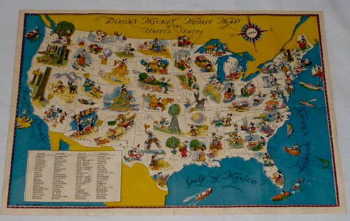
Sold2022Walt Disney Dixon's Mickey Mouse Map of United StatesEarly Disneyana collectible map. Copyright Walt Disney Enterprises 1935. Rare early pictorial map of the United States , richly illustrated with Disney character vignettes in each of the 48 states, MiSee Sold Price
Sold2024Rare Antique Map - Hudson Bay Chart - Old Map of North America - Bellin - Jacques"Carte de la Baye de Hudson". Its finely engraved, hand-coloring engraved map from the Dutch edition of acques Nicolas Bellin Histoire "General of Travel". Published in Amsterdam. A handsome chart ofSee Sold Price
Sold2021(6) Commemorative Half Dollars.(6) Commemorative half dollars. 1935-S California Pacific International Expo, 1935-D Texas Independence, 1936-S SF Oakland Bay Bridge, 1936 Cleveland Centennial, 1946 Booker T. Washington, 1952 GeorgeSee Sold Price
Sold2020Virginia & Maryland. I land rare map of the ChesapeakeTitle: Virginia & Maryland. I land rare map of the Chesapeake bay. Date/Period: 1732/1736 Materials: Copper plate engraved Dimensions: 13 1/2 x 9” By. H. MOLL. From atlas minor. Published. LondonSee Sold Price
Sold2024Map to Acquaint You with the Great Mission Bay Project. 194...Map to Acquaint You with the Great Mission Bay Project. 1948. San Diego: Baker Realty Co. Rare early map of Mission bay with many unrealized concepts including the Trap and Skeet Shooting area, 18 holSee Sold Price
Sold2020Bay of Fundy. RARE. Best map of area to date.Title: Bay of Fundy. RARE. Best map of area to date. Date/Period: 1732/1736 Materials: Copper plate engraved Dimensions: 17 1/4 x 9” By. H. MOLL. From atlas minor. Published. London Reserve: $240.See Sold Price
Sold2022Large Rare Map of Waterford Maine by Daniel Chaplin1850, hand colored, 37 x 29.5 inches, sight. Framed, wrinkles and limited splitting.See Sold Price
Sold2023Rare map of Upper Territories by Mathew Carey, 1814Early and rare map of the old Northwest Territory. In this map the area of Michigan has yet to be understood. The extents of Saginaw Bay and Green Bay are also more or less guessed at. The map reflectSee Sold Price
Sold2022A RARE GRIBBROEK 1935 NATIVE AMERICAN POSTERRobert Gribbroek (1906-1971) historical pictorial map of New York State focused on its Native American tribes by Arthur Caswell Parker (1881-1955). Filled with portraits of prominent persons and sceneSee Sold Price
Sold20211930 Shurtleff Pictorial Map of Massachusetts -- Map ofTitle: 1930 Shurtleff Pictorial Map of Massachusetts -- Map of Massachusetts The Old Bay State Cartographer: E. Shurtleff Year / Place: 1930, New York Map Dimension (in.): 24 x 37 in. This is a very iSee Sold Price
Sold2017Bellin: Antique Map of Hudson Bay, 1770Map: Hudson Bay Date Printed: 1770 Cartographer: N. Bellin Material/Medium: Paper Size: 12 3/4" x 9 1/2" Rare Map. Printed in Paris. From the Atlas Portrait Jacques-Nicolas Bellin(1703-1772) was a FreSee Sold Price
Sold2021Railroad Lock Keys (7), CA - SF Bay Area RR LinesID Marks: EBSRYSLTD (East Bay Street Railways); KEY SYS (Key System (San Francisco - East Bay)); KEY SYSTEM (Key System); KSTCO (Key System Co); OTRY (Oakland Terminal RY); SFOTRY (San Francisco OaklaSee Sold Price
Sold2022Bayville / Locust Valley / Oyster Bay. Northport, NY:Bayville / Locust Valley / Oyster Bay. Northport, NY: Sea Gull Graphics, 1983. Color pictorial map poster showing the area’s businesses, contemporary and historical vessels in Long Island SoundSee Sold Price
Sold2017Vintage Pictorial Map of Newport, RI & Ten Mile DriveMap: Pictorial Map of Newport, RI and Ten Mile Drive Maker: Mount Hope Bridge Corporation Publication Date: 1937 Geographic Area: United States Body of Water: Narragansett Bay ConditoiN: Very good. ASee Sold Price
Sold2021RARE MAP OF RHODE ISLAND DRAWN BY S. LEWIS, 1778RARE MAP OF RHODE ISLAND DRAWN BY S. LEWIS, ENGRAVED BY BAY JONES, PHILADELPHIA, AUG. 29, 1778; MAP WITH MARGINS MEASURES 17" X 10 3/4"See Sold Price
5 days LeftMichael's GalleryRalph Baker (Impressionist - Coastal Seacape) Signed Original Watercolor$550
BonhamsMARKHAM (CLEMENTS) The Land of Silence: A History of Arctic and Antarctic Exploration, FIRST EDI...£30(3 bids)


![Rare map of Oakland with ms. transit lines 1893: Heading: (California - Oakland) Author: Dingee, William J. Title: William J. Dingee's Map of Oakland, showing the properties of the Mutual Investment Union. 1893 Place Published: [Oakland?] Publisher:](https://p1.liveauctioneers.com/642/218849/112379278_1_x.jpg?height=310&quality=70&version=1631923877)
![Beautiful map of S.F. Bay Region 1873: Heading: (California - San Francisco Bay Area) Author: California, State Geological Survey Title: Map of the Region Adjacent to the Bay of San Francisco... Place Published: [n.p.] Publisher: Date](https://p1.liveauctioneers.com/642/204898/103986346_1_x.jpg?height=310&quality=70&version=1621652446)