Sold2022Prime example of 1860 California mapBeautiful map of California with excellent original hand coloring and in prime condition. Forts, towns, railroad lines, coastal features, travelers’ routes and geographical features are shown.See Sold Price
Sold20211860 Mexico, Central Amer. - MitchellA fine example of Mitchell's 1860 map of Mexico, Central America, and the West Indies from the Mitchell New Universal Atlas of 1866. Depicts the region in considerable detail with notations regardingSee Sold Price
Sold2022County Map of California, Mitchell 1860Lovely hand-colored map of California during the Civil War era. One of the earliest maps of California to appear in an American Atlas. Shows California divided into counties, showing all major towns aSee Sold Price
Sold2019County Map of California, Mitchell 1860Lovely handcolored map of California during era of the Civil War. Published in the 1864 Mitchell General Atlas by S. Augustus Mitchell. Nice impression. Tiny water stain at lower left corner paper edgSee Sold Price
Sold20171860 County Map of California1860 County Map of California Inset showing settlements in Great Salt Lake County. S. Augustus Mitchell, Jr. Engraved map with original hand-coloring by counties. Beautiful map of California with inseSee Sold Price
Sold20191855 Colton map of Calif. - fine cond.Issued roughly six years after the 1849 California Gold Rush, this is a beautiful and clean 1855 early edition example of Colton's map of California. Colton's California with its San Francisco inset bSee Sold Price
Sold2023Excellent 1860 map of Baltimore by Samuel A. Mitchell, Jr.Nice example of Samuel Augustus Mitchell Jr’s map of Baltimore with the vivid outline hand coloring that sets this edition off from other editions. Shows wonderful detail at the street level, inSee Sold Price
Sold2023VINTAGE CALIFORNIA STATE MAPS / TRAVEL EPHEMERA, UNCOUNTED LOTVINTAGE CALIFORNIA STATE MAPS / TRAVEL EPHEMERA, UNCOUNTED LOT,for San Diego, with Shell and Texaco examples.20th century. Provenance: From the Dean and Leann Lindsey collection, Phoenix, AZ.See Sold Price
Sold2023VINTAGE CALIFORNIA STATE MAPS / TRAVEL EPHEMERA, UNCOUNTED LOTVINTAGE CALIFORNIA STATE MAPS / TRAVEL EPHEMERA, UNCOUNTED LOT,for the Bay Area, with Conoco and Shell examples.20th century. Provenance: From the Dean and Leann Lindsey collection, Phoenix, AZ.See Sold Price
Sold2024Francis McNally - Antique Map of California & MinnesotaThis is a fine example of McNally's System of Geography by: Francis McNally, published by A.S. Barmes & Co. in 1875. This atlas was made for schools, academies, and seminaries to teach students aboutSee Sold Price
Sold201819th C Map Oregon, Washington, Idaho, & Part of Montana**Originally Listed At $100** Samuel Augustus Mitchell Jr. (American), "Map of Oregon, Washington, Idaho and Part of Montana." ca. 1860. A fabulous example of S. A. Mitchell Junior's 1866 map of WashiSee Sold Price
Sold20221856 Messages of US President 35 Atlas MAPS Florida1856 Messages of US President 35 Atlas MAPS Florida New York California Pierce Throughout the 19th-century, printed examples of Congress reports and messages of the United States Presidents were regulSee Sold Price
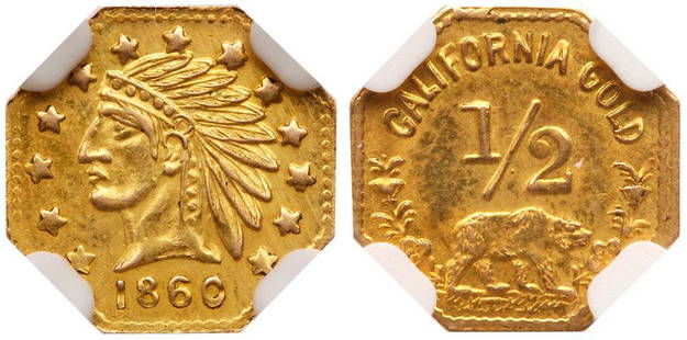
Sold20221860-Dated 1/2 Octagonal Indian Head California Gold Token, 11.3mm1860-Dated 1/2 Octagonal Indian Head California Gold Token, 11.3mm. Bear #2c. Well struck. Strong luster and lovely gem surfaces. The only example graded at NGC. Estimated Value $750 - UPSee Sold Price
2018Mitchell: Antique Map of Palestine, 18641864 hand-colored map of Palestine by S. Augustus Mitchell. A beautiful example of S. A. Mitchell Jr.'s 1864 map of Palestine, Israel or the Holy Land. Updated from the 1860 variant with new details,See Sold Price
Sold20171864 hand-colored map of Palestine by S. AugustusA beautiful example of S. A. Mitchell Jr.'s 1864 map of Palestine, Israel or the Holy Land. Updated from the 1860 variant with new details, an inset of Jerusalem, and a new 1864 copyright. Includes boSee Sold Price
Sold20201892 Cowles Civil War Map of Utah, Nevada and Most ofTitle: 1892 Cowles Civil War Map of Utah, Nevada and Most of California plus March Route of the Army of Tennessee -- Territory and Military Department of Utah…1860 [and] March Routes of Army of TennSee Sold Price
Sold2021W. Coast of U. S. - Frisco to San Diego. 1852Nicest example of this map I’ve seen in twenty years. Perhaps the most attractive and desirable of the original U.S. Coast Survey charts of the California Coast, with 17 painstakingly hand-colorSee Sold Price
Sold2024Carte De La Californie Suivant (early Group of 5 California maps) 1772 [171215]A spectacular set of 5 maps showing California history from 1604 to 1767. Measures 15x12[x=#8221/]. 1) Earliest map (upper right) is based upon a manuscript map by Mathieu Neron Pecci drawn in FlorencSee Sold Price
Sold201653.Fine Damascene Dress Cane- Ca. 1900- A prime example53.Fine Damascene Dress Cane- Ca. 1900- A prime example of this type of work with great attention paid to every detail of the handle, fine condition, exotic hardwood shaft and a metal ferrule. H.- 4��See Sold Price
Sold2017UNITED STATES 1860 MAP, J.W. LOWRY, TERRITORIESFramed map of "The United States of North America (General Map)", c. 1860, "drawn and engraved by" J.W. Lowry (Joseph Wilson Lowry, British, 1803-1879), published by Blackie & Son, Glasgow, EdinburghSee Sold Price
Sold2023An 1860 Map of New York State by J.H. French and an 1846 Mitchell's Reference & Distance Map of theAn 1860 Map of New York State by J.H. French and an 1846 Mitchell's Reference & Distance Map of the United States by J.H. Young58 x 72 1/2 inchesOther Notes: Fontaine's Auction Gallery can arrange shiSee Sold Price
Sold20231860 California Gold coin1860 California Gold coin. 1/2 dollar on obverse. In case.See Sold Price
Sold20191860 California Life Illustrated Golden Gate Gold Mine1860 California Life Illustrated Golden Gate Gold Mine San Francisco Missionary William Taylor (1821-1902) was a Methodist minister specializing in "street preaching." The Methodist church sent him toSee Sold Price
Sold2024Augustus Mitchell 1860 Map Of TexasAugustus Mitchell 1860 Map Of Texas, Hand Colored Engravings On Paper, Sight 12 X 14 Inches, Later Frame 19 X 22 X 1 Inch, Paper Toned Especially At Edges By Mat, Not Examined Out Of Frame. See PhotosSee Sold Price
9 hrs LeftJasper52BLACK SEA Istanbul Odessa Sevastopol Sinop Varna views. TALLIS / RAPKIN 1860 map$40
Featured9 hrs LeftJasper52TURKEY IN EUROPE. Constantinople/Istanbul view. Balkans. TALLIS/RAPKIN 1860 map$20
9 hrs LeftJasper52BALTIC SEA Kronstadt St Petersburg Turku Tallinn Helsinki TALLIS/RAPKIN 1860 map$50
Jun 23Schilb Antiquarian Rare Books1848 Emory Military Reconnaissance 1ed California MAP Indians Texas New Mexico$1
May 22Dalshire International"The Stag Party" Hand Signed Limited Edition Lithograph by Robert Deyber, #71/275$10(1 bid)
20 hrs LeftBidhausGilbert Rohde for Herman Miller Three-Drawer Chest / Dresser w/ Leather Faced Drawer Fronts USA c.$10
May 23Weatherham Estate TreasuresAfter Colonel John Campbell "Cupid Kiss" Sculpture - Carrara White Marble (2.0lbs)$255
6 hrs LeftRapid Estate Liquidators and Auction GalleryNavitec Tango Charlie Chronograph Quartz Mens Watch$625
Featured6 days LeftJasper5218th Century Gustavian Sofa, Daybed, Swedish Paint Decorated, Sweden$12,000


![1892 Cowles Civil War Map of Utah, Nevada and Most of: Title: 1892 Cowles Civil War Map of Utah, Nevada and Most of California plus March Route of the Army of Tennessee -- Territory and Military Department of Utah…1860 [and] March Routes of Army of Tenn](https://p1.liveauctioneers.com/5584/162681/82155385_1_x.jpg?height=310&quality=70&version=1583273475)

![Carte De La Californie Suivant (early Group of 5 California maps) 1772 [171215]: A spectacular set of 5 maps showing California history from 1604 to 1767. Measures 15x12[x=#8221/]. 1) Earliest map (upper right) is based upon a manuscript map by Mathieu Neron Pecci drawn in Florenc](https://p1.liveauctioneers.com/2699/324080/174413209_1_x.jpg?height=310&quality=70&version=1711485545)


