Sold20201886 Map of Indian NationsAuthor: Clare Title: 1886 Map of Indian Nations Medium: Ink on Paper Dimensions: 14.5"X11" Description: Map dated 1886 part of Watson's General Atlast. Engraved by I.S. Clare it captures the Indian NaSee Sold Price
Sold2018Five Early Prints1. Grand Army of the Republic, 20 x 16 2. Ulysses S. Grant print in oval frame, 12 x 10 3. 1886 Map of Bellows Falls, 14 1/2 x 26" 4. Abe Lincoln 20 x 16 5. Truman A. Nichols Civil War Volunteer 15 xSee Sold Price
Sold20191753 SlaveTrade Map of Africa Cape Blanco to AngolaSlave Trade map “A new and correct Map of the Coast of Africa from Cape Blanco ..to the Coast of Angola”, printed from J and P Knapton, 1753 and for Universal Dictionary of Commerce. Fine foldingSee Sold Price
Sold20171886 Williams Pocket Map of Greater BostonTitle: 1886 Williams Pocket Map of Greater Boston -- Map of Boston and the Country Adjacent, from Actual Surveys Cartographer: A Williams Origin/Date: 1886, Boston Size: 31 inches x 21 inches folded oSee Sold Price
Sold20221759 Voyages in CARIBBEAN Jamaica Barbados MAPS Pirates America Slave Trade1759 Voyages in CARIBBEAN Jamaica Barbados MAPS Pirates America Slave Trade The General History of Voyages by abbe Prevost is one of the largest and most impressive collections of stories of expeditioSee Sold Price
Sold20201865 Southern Rebellion Confederate Civil War Slaves1865 Southern Rebellion Confederate Civil War Slaves CSA Illustrated COLOR MAP A rare first edition of William Craft’s “The Southern Rebellion.” Crafts spends a great deal of time and effort onSee Sold Price
Sold2021Scarce map of Indian Territory, 1886Most likely the final map of Indian Territory produced by the Colton firm. Map is colored by Indian Nations, and shows a massive Cheyennes and Arapahoes Nation at the top. Over two dozen Native AmericSee Sold Price
Sold2023GREECE & BALKANS. Albania Bulgaria Serbia Croatia Bosnia Aegean. MALLET 1683 mapTITLE OF THE MAP: 'De la Turquie Meridionale en Europe' (De L'Europe) The map extends from Greece northwards to the Danube. Shows Romania. Serbia. etc. DATE PRINTED: 1683 IMAGE SIZE: Approx Overall paSee Sold Price
Sold2024GREECE & BALKANS. Albania Bulgaria Serbia Croatia Bosnia Aegean. MALLET 1683 mapTITLE OF THE MAP: 'De la Turquie Meridionale en Europe' (De L'Europe) The map extends from Greece northwards to the Danube. Shows Romania. Serbia. etc. DATE PRINTED: 1683 IMAGE SIZE: Approx Overall paSee Sold Price
Sold2023Dalmatia maritima… Croatia Montenegro Bosnia. ROSSI/CANTELLI DE VIGNOLA 1689 mapTitle: Dalmatia maritima… Croatia Montenegro Bosnia. ROSSI/CANTELLI DE VIGNOLA 1689 map Description: Dalmatia maritima Occidentale e Dalmatia maritima Orientale [Western & eastern Dalmatia] by PSee Sold Price
Sold20201886 Holy Land & Book BIBLE Illustrations MAP Damascus1886 Holy Land & Book BIBLE Illustrations MAP Damascus Lebanon Archaeology In 1859, American missionary William Thomson published a report recounting his experiences in the Middle East – ‘The LandSee Sold Price
Sold20191886 1st ed Memoirs of Robert E Lee Civil War1886 1st ed Memoirs of Robert E Lee Civil War Confederate Gettysburg MAPS Long “It is well that war is so terrible, or we should grow too fond of it.” – Robert E. Lee Armstead Long’s ‘MemoirSee Sold Price
Sold2022Voyages.- Cruise of Her Majesty's Ship "Bacchante" 1879-1882 (The), 2 vol., first edition, 1886.Voyages.- Cruise of Her Majesty's Ship "Bacchante" 1879-1882 (The), 2 vol., first edition, half-titles, plates and maps, presentation ink inscription to half-titles, some light foxing, mainly to vol.See Sold Price
Sold2022Robert Louis Stevenson 'Kidnapped'. Cassell & Company, 1886. 1st EditionStevenson, Robert Louis 'Kidnapped'. Cassell & Company, 1886. 1st Edition Hardback copy w/ blue cloth boards and gold lettering. Deckled edge. Folding map & Ads dated "5G.4.86" and "5B.4.86". 311pp. WSee Sold Price
Sold2024Robert Louis Stevenson 'Kidnapped'. Cassell & Company, 1886. 1st EditionStevenson, Robert Louis 'Kidnapped'. Cassell & Company, 1886. 1st Edition Hardback copy w/ blue cloth boards and gold lettering. Deckled edge. Folding map & Ads dated '5G.4.86' and '5B.4.86'. 311pp. WSee Sold Price
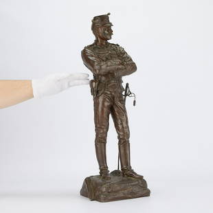
Sold2023Charles Anfrie Bronze Soldier Statue 1886Charles Anfrie (French, 1833-1905). Bronze statue titled "Quana Vous Voudrez (Whenever You Want)" depicting a Chasseurs d'Afrique officer standing with his arms crossed with a map reading &qSee Sold Price
Sold20201886 1st ed Kidnapped Robert Louis Stevenson Scotland1886 1st ed Kidnapped Robert Louis Stevenson Scotland Jacobite Highlander MAP Robert Louis Stevenson was a 19th-century Scottish author known for his adventure novels such as ‘Dr. Jekyll and Mr. HydSee Sold Price
Sold2017Birdseye view map colored lithograph "View of BeverlyBirdseye view map colored lithograph "View of Beverly Massachusetts 1886", published by W. A. Greenough & Co., Old Print Shop label on verso, sight size 20 1/4" x 26 1/2". Provenance: Property from CrSee Sold Price
Sold2020Historical Map of Nantucket by Rev. F.C. Ewer, 1886Historical Map of Nantucket Surveyed and Drawn by the Reverend F.C. Ewer D.D., Published by J.B. Swain, Nantucket, circa 1886. 32 ¼ in. x 47 ½ in. Provenance: Estate of Linda Loring, 4 Rays Court, NSee Sold Price
Sold2022ANDRY, Margaret Wendt. A Tourist Map of Louisiana. Circa 19...ANDRY, Margaret Wendt. A Tourist Map of Louisiana. Circa 1960s. Offset lithograph pictorial map depicting figures in Louisiana history, among them slaves, conquistadors, and settlers, as well as buildSee Sold Price
Sold20191886 1ed Greely Arctic Explorations Voyages Expedition1886 1ed Greely Arctic Explorations Voyages Lady Franklin Bay Expedition Map 2v This ‘Three years of Arctic service’ is a narrative by Adolphus Greely of the United States expedition Lady FranklinSee Sold Price
Sold2022JOHN TALLIS (1817-1876) AN AMERICAN CIVIL WAR MAP, "United States," LONDON, CIRCA 1863,JOHN TALLIS (1817-1876) AN AMERICAN CIVIL WAR MAP, "United States," LONDON, CIRCA 1863, hand-colored lithograph on wove paper showing, "Federal, Non Slave Holding States (Red); Border, Slaveholding (BSee Sold Price
Sold2022Aldro T. Hibbard Personal Materials, EphemeraPersonal material belonging to Aldro T. Hibbard (1886-1972), including family bible, slides of his paintings, photos, maps, etc.See Sold Price
Sold2017Africa.- Bosman (William) Coast of Guinea, secondAfrica.- Bosman (William) A New and Accurate Description of the Coast of Guinea, Divided in the Gold, the Slave, and the Ivory Coasts, 2 parts in 1, Second edition, folding engraved map and 7 plates,See Sold Price
4 hrs LeftJasper52LA PLATA. Banda Oriental del Uruguay. Paraguay w/o Gran Chaco.Argentina 1886 map$10
BonhamsLEAR (EDWARD) Autograph fair copy of 'Some Incidents in the Life of My Uncle Arly', 19 May 1886;...£4,000
Jun 08Early American History Auctions1862 Civil War Dated, Union General David Hunter Autograph Letter Signed Involving 3 Union Generals$600
BonhamsLONDON PARKS LARWOOD (JACOB) The Story of the London Parks, John Camden, [c. 1880]--SMITH (THOMA...£1,600
Featured6 days LeftJasper52Horse market, Cairo (A hot bargain). Etching after F.A. Bridgman (American, 1847 - 1928)$140


![Dalmatia maritima… Croatia Montenegro Bosnia. ROSSI/CANTELLI DE VIGNOLA 1689 map: Title: Dalmatia maritima… Croatia Montenegro Bosnia. ROSSI/CANTELLI DE VIGNOLA 1689 map Description: Dalmatia maritima Occidentale e Dalmatia maritima Orientale [Western & eastern Dalmatia] by P](https://p1.liveauctioneers.com/5584/303867/162107203_2_x.jpg?height=310&quality=70&version=1696356363)


![LONDON PARKS LARWOOD (JACOB) The Story of the London Parks, John Camden, [c. 1880]--SMITH (THOMA... (1 of 8)](https://p1.liveauctioneers.com/1043/319451/178359231_1_x.jpg?height=282&quality=70&version=1716978902)


![Carroll, Lewis [Charles Lutwidge Dodgson] (1 of 1)](https://p1.liveauctioneers.com/94/330664/178342370_1_x.jpg?height=282&quality=70&version=1716466933)


