Sold2015Pr. Antique Maps, Danker Dankerts & Americas &Pr. Antique Maps, Danker Dankerts & Americas & Caribbean Map, both approx. 18" x 23" sightSee Sold Price
Sold2024Antique Maps - Americas - Emanuel Bowen - North America - South AmericaMap "A new general map of America. Drawn from several accurate particular maps and charts, and regulated by astronomical observations. By Eman. Bowen". An impressive publication by Emanuel Bowen, "A NSee Sold Price
Sold2017Sanson: Antique Map of Americas with Atlantis, 1699Map: 1699 Sanson Map of Americas with Mythical Atlantis and California as Island -- Atlantis Insula, a Nicolao Sanson Antiquitati Restituta; nunc demum Majori Forma Delineata, et in Decem Regna, iuxtaSee Sold Price
2021Michael Mercator RARE Antique Map of the AmericasAntique map of "America and New India" (America Sive India Nova) produced by Michael Mercator (c. 1567-1600), Gerard Mercator’s grandson. Hand colored engraved map. Duisburg, 1595 (Amsterdam, 1See Sold Price
Sold2017Meullers: Antique Map of the Americas, 1758Title: 1758 German map of America with peculiar (and late) Island of California. America oder Neu Europa Map maker: Johann Bernhard Meullers, Leben un gewohnheiten der Ostjacken Place and Year: [BerliSee Sold Price
Sold2017Mentelle: Antique Map of the Americas, 1798Title/Content of Map: Fine antique map of the Americas. Carte générale et Politique de l Amérique Date Printed: 1798 Cartographer: Mentelle and Chanlaire Size (inches): 16 x 13 Original hand colorSee Sold Price
Sold2017de l’Isle / Buache: Antique Map of the Americas, 1790Map: Carte d'Amerique, Dressee pour l'instruction Cartographer: Guillaume De l'Isle / Philippe Buache / J. A. Dezauche Place & Date: Paris / 1790 Size: 23 1/2 x 18 1/2" Condition: outline and wash colSee Sold Price
Sold2018Delamarche: Antique Map of the Americas, 1818Title/Content of Map: Carte Generale De L'amerique Divisee En Ses Principaux Etats Date Printed: 1818 Cartographer: DELAMARCHE, FELIX apres Robert de Vaugondy Size: 21X23.3 Period map with areas of noSee Sold Price
Sold2017Mallet: Antique Map of the Americas, 1683Map Title: 'Nouveau Continent avec plusieurs Isles' Australia appears partly outlined. AMERICAS SHOWING CALIFORNIA AS AN ISLAND. 'Nouveau Continent'. Date Printed: 1683 Image Size: Approx Overall pageSee Sold Price
Sold2017Janvier / Lattre: Antique Map of the Americas, 1772Map: L'Amerique divisee par Grands Etats Cartographer: J. Janvier / J. Lattre Place & Date: Paris / 1772 Size: 17 1/2" x 12" Condition: outline color (wash in cartouche); very light overall age toningSee Sold Price
Sold2017Janvier/Vaugondy: Antique Map of the Americas, 1806Title/Content of Map: L'Amerique showing early independent United States Date Printed: 1806 Cartographer: Janvier/Vaugondy Material/Medium: Paper Size: 19" x 15" Hand colored. Copperplate engraving. SSee Sold Price
Sold2018SDUK: Antique Map of the Americas, Gnomonic ProjectionAMERICAS. Gnomonic Projection. Texas Republic borders. USA Mexico. The map was originally engraved prior to or during the Texas Republic, and borders on the map have been drawn to show Texas as beingSee Sold Price
Sold2017Thomson: Antique Map of The Americas, 1816Map: The Americas Cartographer: J. Thomson Place & Date: Edinburgh / 1816 Size: 20 1/2" x 18 1/4" Condition: outline color; overall age toning The elegant Western Hemisphere map from Thomson's New GenSee Sold Price
Sold2017Buchon: Antique Map of the Americas in 1825Map: Amerique Historique, Physique et Politique en 1825 Cartographer: Buchon / J. Carez Place & Date: Paris / 1825 Size: 26 3/4" x 19 3/8" (overall) Condition: wash color; light overall age toning; miSee Sold Price
Sold2023GROUP OF 5 HAND COLORED MAPS OF THE AMERICASGroups of five hand colored antique maps of the Americas, comprising "America Merioio-Nalis (South American)" circa 1620, "Tabula Magellanica Qua Tierre Del Fuego (Strait of Magellan)" circa 1640, "IlSee Sold Price
Sold2023Guillaume De L'Isle Philippe Buache Large Antique French Map of the AmericasImportant map of Guillaume de L'Isle corrected by Philippe Buache and edited by Dezauche in 1800 ,after the conclusion of the American revolutionary war and the treaty of Paris Dezauche updated the neSee Sold Price
Sold2018Antique Hand Colored Maps of The AmericasAntique Hand Colored Maps of The Americas. This lot features two 19th century hand colored maps of North America and South America from the Carey and Lee Atlas American Edition 1823-24. Both maps areSee Sold Price
Sold2023Antique Map - Map of Canada - Hudson Bay - Labrador - Arctic Ocean - AmericasThis fine engraving map of Canada by Jacques-Nicolas Bellin originates from "Histoire générale des voyages..." by Antoine François Prévost d'Exiles in 1757. The author depicts Hudson's BaySee Sold Price
2018Philip: Antique Map of North and South America, 1852Title/Content of Map: 1852 Philip Map of North and South America -- America Date Printed: 1852, Liverpool Cartographer: G Philip Size: 11.9 x 9. 1 in. This is a handsome map of the Americas, offeringSee Sold Price
2018Becker: Antique Map of North and South America, 1850Title/Content of Map: 1850 c. Becker map of North and South America -- America Date Printed: 1850 c., London Cartographer: F Becker & Co. Size: 10.1 x 8 in. This is an interesting map of the Americas,See Sold Price
Sold2023Kircher, pub. 1678 - Map of the Americas (Hydrological and Subterranean markings)This scientific engraving is Athanasius Kircher's Mundus subterraneus, in XII Libros digestus; Qvo Divinum Subterrestris Mundi Opificium, mira Ergasteriorum Natur? in eo distributio, verbo PantamorphoSee Sold Price
Sold2023AMERICA H. Moll Geographer 1732 MapHerman Moll 1732 Map of the Americas, North and South America with California depicted as an island. Hand Colored engraving 8 1/2 x 11 in Matt.See Sold Price
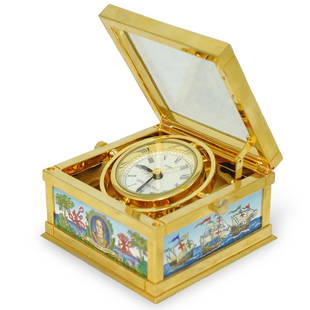
Sold2019Halcyon Days Enamel ClockDESCRIPTION: A Halcyon Days Christopher Columbus Enamel Table Clock. Features enameled decoration with Christopher Columbus motif and a map of the Americas, top opens and clock face lifts up. Marked oSee Sold Price
Sold2023America. North/South Americas. California Missions. THOMSON 1830 old mapTITLE/CONTENT OF MAP: 'America' DATE PRINTED: 1830 IMAGE SIZE: Approx 53.0 x 64.0cm, 20.75 x 25.25 inches (Large); Please note that this is a folding map. TYPE: Antique early 19th century atlas map wiSee Sold Price
2 hrs LeftTrillium Antique Prints & Rare BooksPrevost - Pair of Engravings of Chinese Boats or Junks$50
2 hrs LeftTrillium Antique Prints & Rare BooksPrevost - Pair of Engravings of Indian Coast and Ocean$50
2 hrs LeftTrillium Antique Prints & Rare BooksLinnaeus - Pair of Bird Engravings: Purple Indian Creeper & Green and Cinereous Tody$30(2 bids)
2 hrs LeftTrillium Antique Prints & Rare BooksLinnaeus - Pair of Bird Engravings: Peacock Pheasant of China and Purple-breasted Chatterer$30(2 bids)
2 hrs LeftTrillium Antique Prints & Rare BooksHolbrook - Pair of Frog or Toad Lithographspair - Frog or Toad$50
2 hrs LeftTrillium Antique Prints & Rare BooksDuhamel, Poiteau, & Turpin - Pair of Engravings of Pears$300
2 hrs LeftTrillium Antique Prints & Rare BooksDuhamel, Poiteau, & Turpin - Pair of Engravings of Pears$300