Sold2022Faden Map of the Plan of the Attack of the Forts Clinton & Montgomery with beautiful original handFADEN, William (1749-1836). Plan of the Attack of the Forts Clinton & Montgomery upon Hudsons River which were Stormed by His Majesty's Forces under the Command of Sir Henry Clinton, 6th of Octr. 1777See Sold Price
Sold2022A Plan of Charles Town the Capital of South Carolina… Charleston. LODGE 1780 mapTITLE/CONTENT OF MAP: 'A Plan of Charles Town the Capital of South Carolina, with the Harbour, Islands and Forts; the Attack on Fort Sulivan, by His Majesty's Ships under Sir Peter Parker, in 1776; thSee Sold Price
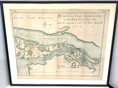
Sold2021Map Of Attacks Of Fort Washington 16th, November 1776.D.T. Valentine's Manual Of 1861, Map Of Attacks Of Fort Washington by His Majesty's forces under the command of General Sir Will Howe K.B. 16th of November 1776 (Revolutionary War) .. Hand colored. MaSee Sold Price
Sold2015William Aiken Walker“Plan of the Approach and Attack on Fort Sumter, by the Federal Iron Clad Fleet 7 April 1863.” Signed [in type]: Wm A Walker, C.S. Eng. Corps. Charleston.Walker (born March 11, 1839 in Charleston,See Sold Price
Sold2016Map of New York City & Plan of Fort Washington (PortEngraved by George Hayward for D.T. Valentine's Manual. Map features northern Manhattan with Revolutionary War battles and troop movements, hightlighted by number on right side of map. The full titleSee Sold Price
Sold2020ANTWERP ANTWERPEN ANVERS town city map. Schelde fortsTITLE/CONTENT OF MAP: 'ANTWERP (ANTWERPEN) (ANVERS); inset plan of the Schelde and forts from Antwerp to Lillo' DATE PRINTED: This map was originally published by Baldwin & Cradock in 1832; this dateSee Sold Price
Sold2023Framed Map of Fort Worth StockyardsVintage map of the U.S. Department of Agriculture's 1937 master plan for the Fort Worth Stockyards, framed sight: 22 x 30 in., frame: 33 x 45 in. Provenance: The Dallas, Texas collection of a lSee Sold Price
Sold2023PERIOD MAP DETAILING WOLFE'S ATTACK ON QUEBEC CITYAn excerpt for the London Mag, left corner titled "A Plan of the River St. Lawrence, from the Falls of Montmorenci to Sillery, with the Operations of the Siege of Quebec", top right corner "A Plan ofSee Sold Price
Sold2023Map Of Philadelphia 1794 Thomas Mifflin GovernorMap Of Phila 1794, Thomas Mifflin Governor and Commander in Chief of the State of Pennsylvania. Plan for the City and Suburbs of Philadelphia. 1973 reproduction, #38 of 500, Historical Urban PlansSee Sold Price
Sold2017Faden & Stedman: Antique Map, Seige of Savannah, 1794Title/Content of Map: Seige of Savannah Date Printed: 1794 Cartographer: Faden & StedmanMaterial/Medium: Engraving Size: 28 1/2" x 22 1/2" Original engraving from Stedman's History of the American WarSee Sold Price
Sold2017Johnson’s New Military Map of the US, 1863Johnson’s New Military Map shows states rather than military zones. 1863. 17 x 23.75 inches. Johnson’s New Military Map of the United States Showing the Forts, Military Posts with Enlarged Plans oSee Sold Price
Sold2021CIVIL WAR-ERA JOHNSON'S MILITARY MAP UNITED STATESFramed engraving with color on paper, "Johnson's New Military Map of the United States, Showing the Forts, Military Posts & c., with Enlarged Plans of Southern Harbors from Authentic Data Obtained atSee Sold Price
Sold2018Johnson's New Military Map of the United States ShowingTitle: Johnson's New Military Map of the United States Showing the Forts, Military Posts &C. With Enlarged Plans of Southern Harbors Publication Date: 1864 Cartographer: JOHNSON, ALVIN JEWETT PublisheSee Sold Price
Sold20201861 Civil War military map in full hand-colorLarge format, double-page “Johnson’s New Military Map of the United States showing the Forts, Military Posts &c. with Enlarged Plans of Southern Harbors” by Johnson and Ward. Original and vividSee Sold Price
Sold20211875 h/c map of Florida in fine conditionDetailed map of Florida showing township surveys, forts, canals, swamps, counties, cities, roads, railroads, inland waters, etc. with inset Plan of Florida Keys. Shows Olustee in the north near Lake CSee Sold Price
Sold2018Antique Map - LondonAntique folding map "London in Miniature With The Surrounding Villages, An Entire NEW PLAN …." by Edward Mogg, published by Edward Mogg, No 51 Charing Cross, London made up of 20 paper panels laid dSee Sold Price
Sold2017Thomson: Antique Chart Map of Mediterranean Sea, 1817Chart of the Mediterranean Sea. Bay & roads of Marseilles. The harbour of Genoa. Plan of the Rock and Bay of Gibraltar, shewing the position of the combined fleet and attack of the battering ships inSee Sold Price
Sold2022[MAP-CUBA] KITCHIN, THOMAS. Plan of the Havana and its Environs, with the several posts and attacks[MAP-CUBA] KITCHIN, THOMAS. Plan of the Havana and its Environs, with the several posts and attacks made by the British Forces; under the command of the Earl of Albemarle and Sr. Geo. Pocock, which waSee Sold Price
Sold20171862 Johnson Civil War Military Map of US1862 Johnson Civil War Military Map of US -- Johnson's New Military Map of the United States Showing the Forts, Military Posts &c. all the Military Divisions with Enlarged Plans of Southern Harbors…See Sold Price
Sold2017Revolutionary War MapMap, 18” x 11,” “Plan of the Siege of Charleston in S. Carolina" 1807, publishedC.P. Wayne, Philadelphia, withdrawn from book. Showing the location of downtown Charleston, Fort Sullivan (later nSee Sold Price
Sold20221764 Bellin map of Manhattan (Hayward 1861)Antique city plan of Lower Manhattan, executed by S. Bellin in 1764, redrawn by George Hayward for the Valentine’s Manual of 1861. Includes the Custom House, City Hall, the Fort, the House of tSee Sold Price
Sold2023MAPS IN BOOK, France, Le RougeIncludes Plans of New Orleans and Quebec. France, Atlases. Le Rouge, Recueil des Fortifications Forts et Ports de Mer de France Lave au Pinceau, 1760 (circa). Black & White. This book contains 89 platSee Sold Price
Sold20191794 map of Japan and Korea.1794 map of Japan and Korea. Printed by Laurie & Whittle, 21 by 28 inches. Fair condition with a small tear lower left and age toning.See Sold Price
Sold2018Large Framed 1794 Map of America Laurie & Whittle1794, London New Map of America & The West India Islands. With detailed side maps of California, and Baffin & Hudson Bay. Published by Laurie and Whittle. Map measures approximately 43.5" L x 49.5" H,See Sold Price
Featured19 hrs LeftJasper52Johnson's New Military Map of the United States Showing the Forts, Military Posts &C. With Enlarged$65
2 days LeftJasper52EAST ASIA INDUSTRIES. China Korea East Indies Philippines. Manila plan 1920 map$50
2 days LeftJasper52FRENCH INDOCHINA. N Laos & Annam. Vietnam. Tourane (Da Nang) city plan 1931 map$25
Featured2 days LeftJasper52ASIA.Asien;Volker Race;Religionen Religion 1958 old vintage map plan chart$10
2 days LeftJasper52FRENCH INDOCHINA. N Laos & Annam. Vietnam. Tourane (Da Nang) city plan 1938 map$30
2 days LeftJasper52FRENCH INDOCHINA. N Laos & Annam. Vietnam. Tourane (Da Nang) city plan 1929 map$30
2 days LeftJasper52FRENCH INDOCHINA Indochine. South Laos & Annam. Vietnam. Hue city plan 1929 map$40
2 days LeftJasper52FRENCH INDOCHINA Indochine. South Laos & Annam. Vietnam. Hue city plan 1938 map$40
2 days LeftForum AuctionsLondon.- Newcourt (Richard), After. An Exact Delineation of the Cities of London and Westminster and£500
Jun 07Freeman's | Hindman[MAP]. SARTINE, Antoine Plan de la Barre et du Havre de Charles-Town...1778. RARE REVOLUTIONARY WAR$1,000(1 bid)


![William Aiken Walker: “Plan of the Approach and Attack on Fort Sumter, by the Federal Iron Clad Fleet 7 April 1863.” Signed [in type]: Wm A Walker, C.S. Eng. Corps. Charleston.Walker (born March 11, 1839 in Charleston,](https://p1.liveauctioneers.com/1642/74384/38450843_1_x.jpg?height=310&quality=70&version=1435931017)


![[MAP-CUBA] KITCHIN, THOMAS. Plan of the Havana and its Environs, with the several posts and attacks: [MAP-CUBA] KITCHIN, THOMAS. Plan of the Havana and its Environs, with the several posts and attacks made by the British Forces; under the command of the Earl of Albemarle and Sr. Geo. Pocock, which wa](https://p1.liveauctioneers.com/292/250642/130213656_1_x.jpg?height=310&quality=70&version=1654271664)


![[MAP]. SARTINE, Antoine Plan de la Barre et du Havre de Charles-Town...1778. RARE REVOLUTIONARY WAR (1 of 1)](https://p1.liveauctioneers.com/197/329395/177650540_1_x.jpg?height=282&quality=70&version=1715364962)

