Sold2023MAP: United States - East Coast. Thames River New York London Harbor Long Island to NorwichDescription: United States - East Coast Connecticut - New York. Thames River/ New York London Harbor Long Island to Norwich. Published at Washington D.C. US Department of Commerce, Environmental ScienSee Sold Price
Sold20181984 NOAA New York Harbor Navigational ChartTitle/Content of Map: 1984 NOAA New Your Harbor Navigational Chart Issued for Statue of Liberty Centennial -- United States East Coast; New York - New Jersy; New York Harbor Date Printed: 1984, WashinSee Sold Price
Sold2020Hand Colored Antique Engravings NYC River FrontHand Colored Antique Engravings NYC River Front. Pair of framed hand colored engravings of New York City River Front and Scene on the East River both featuring clipper ships at harbor.See Sold Price
Sold2023MAP: United States - East Coast/ New York. New Jersey/ Hudson RiverDescription: United States - East Coast/ New York. New Jersey/ Hudson River/ New York to Wappinger Creek. PUBLISHED at Washington DC. US Department of Commerce, NATIONAL OCEANIC AND ATMOSPHERIC ADMINISee Sold Price
Sold2023Map: United States– East Coast / Connecticut– New York/ Long Island Western PartDescription: United States– East Coast / Connecticut– New York/ Long Island Western Part. Published at Washington D.C. US Department of Commerce, National Oceanic Service. Measurement apSee Sold Price
Sold2023MAP: United States - East Coast. Connecticut - New York. Long Island Sound - Eastern PartDescription: United States - East Coast. . Connecticut - New York. Long Island Sound - Eastern Part. Published at Washington D.C. US Department of Commerce, Environmental Science services AdministratiSee Sold Price
Sold2023MAP: United States - East Coast/ Approaches to New York/ Nantucket ShoalsDescription: United States - East Coast/ Approaches to New York/ Nantucket Shoals to Five Fathom Bank. For LORAN - C coverage - see reverse side. Published at Washington D.C. US Department of CommerceSee Sold Price
Sold2021Antique Map Lithographs New York City, World MapPair Antique Hand Colored Map Lithographs of New York City, and a World Map. Unframed 18 inches x 23 inchesSee Sold Price
Sold2021Nautical Map / Sea Chart, #362 Block Island Sound andDescription: Nautical Map / Sea Chart, United States East Coast, New York, Long Island, Block Island Sound and Gardiner's Bay, 6th edition, Feb 10/69; Shipping: $20; different rate to California, AlasSee Sold Price
Sold2020Nautical Map / Sea Chart, #1212 Eastern Long IslandDescription: Nautical Map / Sea Chart, United States East Coast, Connecticut - New York, Long Island Sound, Eastern Part, 12th edition feb 10 / 69 ; all measurements are approximate; Folded; ShippingSee Sold Price
Sold20213 antique maps, New York, North East United States3 maps, New York, North East, includes "Carte réduite des côtes orientales de l'Amérique septentrionale : contenant celles des provinces de New-York et de la Nouvelle Angleterre, celles de l'AcadieSee Sold Price
Sold2020USA 1903 Lot of 8 State Maps of New York & East CoastIncl Maine, Vermont/New Hampshire, Mass., Connecticut/Rhode Island, New York South, New York North, New York West and New Jersey. Lithograph Maps Published 1903 by Adam & Charles Black, Edinburgh & LoSee Sold Price
Sold2020Nautical Map / Sea Chart, #224 Oyster & Huntington BaysUnited States East Coast, New York, Oyster & Huntington Bays, South Shore of Long Island Sound, 3rd edition feb 1/43; revised 7/21/58, note heavier bond paper and or better preserved than most; FoldedSee Sold Price
Sold2020Nautical Map / Sea Chart, #1211 MarthaDescription: Nautical Map / Sea Chart, United States East Coast, Rhode Island - Connecticut - New York, Block Island Sound and Approaces9th edition, dec 23/63 stamped CORRECTED ONLY FOR AIDS & HAZARDSSee Sold Price
Sold2017Two Emanuel Bowen Maps Showing the East Coastfrom A Complete System of Geography (London, 1747), copperplate engravings with outline color as follows: A New and Accurate Map of New Jersey, Pennsylvania, New York and New England and A New & AccurSee Sold Price
Sold2020Antique Pair of Chinese Famille Rose VasesAntique Pair of Chinese Famille Rose Vases, w/ Dragon Gilt Handles. Depicting Garden Flowers, Birds & Butterflies. Provenance Upper East Side New York City Estate. Generally Good Condition. DimensionsSee Sold Price
Sold2022Pair of Sabbath candelabrasA pair of antique three light brass Sabbath candelabra with rampant lions in a scrolled framework, Lower East Side New York, circa 1900. H: 13 3/4".See Sold Price
Sold2023US WALL MAPS AND AERIAL VIEW OF NEW YORK CITYA lot of three antique and vintage wall maps of New York. The lot includes a 1914 map of New York bay and harbor, a D. Lambert Railing Co. color map of New York State, and an aerial view of Hudson RivSee Sold Price
Sold2016Bound For New Orleans 1837Early Shipping Bill of Lading from the Rowland G. Hazard papers, dated Harbor of New York, 1837. For 4 bales domestic goods [known as Hazard's Goods] being shipped on the ship called the Saratoga bounSee Sold Price
Sold2016New York Congressman Reeves[NY] REEVES, Henry Augustus, a Representative from New York; born in Sag Harbor, N.Y., December 7, 1832; attended private schools in Sag Harbor, the Southampton Academy, the University of Michigan atSee Sold Price
Sold20241639 Jan Jansson Antique Map of North America Virginia to New York to New EnglandThis beautifully hand coloured, important original antique map of the north east regions of the United States from Virginia, Chesapeake Bay, to New York & New England by Jan Jansson was published in tSee Sold Price
Sold2022Antique Wall Map of Middle EastColton's One Sheet Map of the Lands Mentioned in the Bible. Colton, Ohman & Co., New York: 1885. Wall map on cloth. Eastern Europe, Turkey, Holy Land, Israel. 25 1/2" x 37".See Sold Price
Sold2021CHARLES J. LUNDGREN (American 1911 – 1988) Oil on PanelCHARLES J. LUNDGREN (American 1911 – 1988) Oil on Panel 1976 Eagle Denmark and Radick in New York Harbor, Detail of OP Sail ’76 New York Harbor. Christian Radich, Coast Guard and Eage Denmark fullSee Sold Price
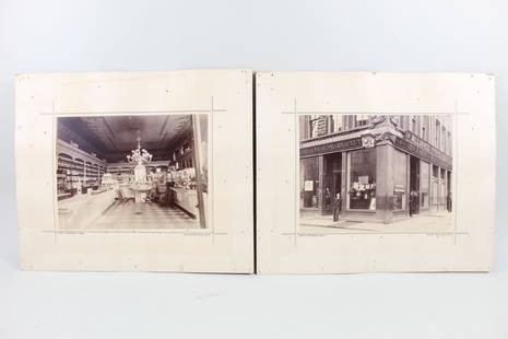
Sold20212 1880's Photos Geo.B.Wray Pharmacy Store,New York,NYCAntique B&W Pair Photos of Geo. B. Wray Pharmacy, NYC. This is a pair of two black & white photographs of the Geo. B. Wray Pharmacy, once located at 339 East 34th St. in New York City. One photo showsSee Sold Price
5 days LeftRipley AuctionsGlenn (Glen) Cooper Henshaw, New York, Indiana, Maryland (1880-1946), S. No. 13 "Providence Harbor",$1,000
5 days LeftTrillium Antique Prints & Rare BooksPrevost - Pair of Engravings of Santo Domingo or Hispaniola$50
5 days LeftRipley AuctionsGlenn (Glen) Cooper Henshaw, New York, Indiana, Maryland (1880-1946), S.N0., 24 Venice Canal, oil on$1,500
1 day LeftJasper521820 LOSS of WINTERTON EAST INDIAMAN WRECKED on MADAGASCAR COAST in 1792 antique$130
Jun 06DOYLE Auctioneers & AppraisersSILVER-GILT MOUNTED VINCENNES PORCELAIN COVERED EWER AND BASIN (POT A L’EAU TOURNE ET JATTE$1,300
1 day LeftJasper521874 Holmes Plan of New York's Upper East Side -- Map of the Common Lands from 76th to 93rd Street$750


![Bound For New Orleans 1837: Early Shipping Bill of Lading from the Rowland G. Hazard papers, dated Harbor of New York, 1837. For 4 bales domestic goods [known as Hazard's Goods] being shipped on the ship called the Saratoga boun](https://p1.liveauctioneers.com/3060/83520/43269587_1_x.jpg?height=310&quality=70&version=1452115037)
![New York Congressman Reeves: [NY] REEVES, Henry Augustus, a Representative from New York; born in Sag Harbor, N.Y., December 7, 1832; attended private schools in Sag Harbor, the Southampton Academy, the University of Michigan at](https://p1.liveauctioneers.com/3060/91263/46813766_1_x.jpg?height=310&quality=70&version=1469723103)