Sold2023Original Theoria Lunae Colored Map from Harmonia Macrocosmica by Andreas Cellarius (1596-1665)An original hand colored map by Dutch-German cartographer Andreas Cellarius (1596-1665), titled Theoria Lunae, Eius Motum per Eccentricum et Epicyclum Demonstrans. Piece comes from the star atlas HarmSee Sold Price
Sold2022Framed Map-Solis Circa Orbem Terrarum RevolutionFramed Map-Solis Circa Orbem Terrarum Revolution. Measures 30 1/2"x27". Hand colored engraving after a celestial map from Dutch-German mathematician and cosmographer Andreas Cellarius(1596-1665) "HarmSee Sold Price
Sold2022Andreas CellariusTheoria Lunae, eius motum per eccentricum et epicyclum demonstans, 1708;Handkolorierter Kupferstich, 43 x 51,7 cm, Blatt 50 x 57,5 cm, aus "Atlas Coelesti seu Harmonia Macrocosmica", Blatt in 2 TeileSee Sold Price
Sold2020Cellarius, Andreas Theoria Lunae, eius Motum perAstronomieCellarius, AndreasTheoria Lunae, eius Motum per Eccentricum et Epicyclum Demonstrans. Kolor. Kupferstich aus Harmonia Macrocosmica. Amsterdam, Valk & Schenk, 1708. Plattengröße 43 x 51 cmSee Sold Price
Sold2022Cellarius, Andreas Theoria Lunae, eius Motum per Eccentricum et Epicyclum Demonstrans. Kolor.Astronomie Cellarius, Andreas Theoria Lunae, eius Motum per Eccentricum et Epicyclum Demonstrans. Kolor. Kupferstich aus Harmonia Macrocosmica. Amsterdam, Valk & Schenk, 1708. Plattengröße 4See Sold Price
Sold2016Andreas Cellarius Coeli Christi Misphae MapAndreas Cellarius, Coeli Christi Misphae, hand colored copper plate engraving from Atlas Coelestis seu Harmonia Macrocosmica. circa 1661 Amsterdam, custom framed in a floating frame. Frame: 36.5" x 32See Sold Price
Sold2020(2 Pc) Framed Antique Celestial Map EngravingsDESCRIPTION: A lot of two antique celestial copperplate engravings from the series Harmonia Macrocosmica by Andreas Cellarius. The first "Sitvus Circvlis Cirvn Terra Coelestibvs Data" Engraved by JohaSee Sold Price
Sold2020Colored engraving star map with zodiac signs, fromColored engraving star map with zodiac signs, from Andreas Cellarius: "Hamonia Macrocosmica", 1660 published by Johannes Janssonius. Map No. 25, Northern Hemisphere, ref. "HEMISPHÆRII BOREALIS COSee Sold Price
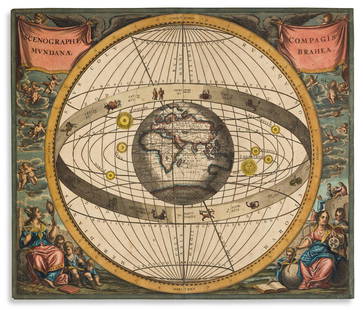
Sold2016Andreas Cellarius Scenographia Compagis Mundanae BraheaAndreas Cellarius, Sceneographia Mundanae hand colored copper plate engraving from Atlas Coelestis seu Harmonia Macrocosmica. circa 1661, Amsterdam, custom framed in a floating frame. Frame: 36.5" x 3See Sold Price
Sold2016Andreas Cellarius Haemisphae Latumau SphaerarumAndreas Cellarius, Haemisphae Latumau Sphaerarum, hand colored copper plate engraving from Atlas Coelestis seu Harmonia Macrocosmica, circa 1661 Amsterdam, custom framed in a floating frame. Frame: 36See Sold Price
Sold2023MAP, Solar System, CellariusCellarius' Striking Chart of the Ptolemaic Cosmography. Solar System. Cellarius/Schenk & Valck, Scenographia Systematis Mundani Ptolemaici, from Atlas Coelestis seu Harmonia Macrocosmica, 1708 (publisSee Sold Price
Sold2020(CELESTIAL.) Cellarius, Andreas. Typus Aspectuum,(CELESTIAL.) Cellarius, Andreas. Typus Aspectuum, Oppositionum et Coniuntionum Etz in Planetis. Hand-colored double-page engraved celestial chart with a map of the world on a north-polar projection shSee Sold Price
Sold20161666 Original Hand Colored Map of Virginiaapprox 21" X 17"...... Pas Caerte van Nieu Nederlandt en de Engelsche Virginies, van Cabo Cod tot Cabo Canrick. (Chart of New Netherland and the English Virginias from Cape Cod to Cape Canrick [i.e. HSee Sold Price
Sold2024Willem Blaeu 1640 "Nova Virginiae Tabula" Original Hand Colored Map of VirginiaThis loose (unframed) and very scarce original antique 1640 hand-colored "Nova Virginiae Tabula" map of Virginia is in good overall condition, with light-age appropriate wear and apparent repairs-oneSee Sold Price
Sold2024Henricus Hondius 1630 "Nova Virginiae Tabula" Hand Colored Map of Virginia and Chesapeake #1Antique, original hand-colored map of Virginia and the Chesapeake Bay originally by Henricus Hondius in 1630 titled "Nova Virginiae Tabula". With French text on reverse final catchword "n'en" and signSee Sold Price
Sold2023Antique Cellarius Colored Star Map With Zodiac SignsAntique Cellarius Celestial Map from Northern Hemisphere -- Hemisphaerii Borealis Coeli et Terrae Sphaeri Cascenographia. Measures approx. 17 1/4" and 20" tall. Please carefully read our terms of saleSee Sold Price
Sold20211661/1707 Corporum Coelestium MagnitudinesBy: Andreas Cellarius - pub. by Valk & SchenkDate: 1661 / 1708 (published) AmsterdamDimensions: 16 x 19.5 inches (40.5 x 45.5 cm)Beautiful celestial map by the famous cosmographer Andreas Cellarius, sSee Sold Price
Sold2023Sauthier & Fadden Revolutionary War Map EngravingAn original 18th Century hand colored engraved topographical map, illustrated by Claude Joseph Sauthier (1736–1802) and published by William Faden (1749-1836), the latter serving as royal geogrSee Sold Price
Sold2017Blaeu Map of BrazilMaritima Brasiliae Universa. Joan Blaeu (1596-1673). Engraved map with original color in part. Amsterdam: Blaeu, 1647. 21 x 24 1/2 inches sheet, 32 1/2 x 36 inches framed. This separately issued and rSee Sold Price
Sold2022(NEW YORK.) John Homer French. The State of New York from New and Original Surveys.(NEW YORK.) John Homer French. The State of New York from New and Original Surveys. Large hand-colored engraved wall map of New York with many inset views and detail maps. 4 sheets joined, 68x73 incheSee Sold Price
Sold2022Blaeu Brasilia, c 1640BLAEU, Joan Blaeu (1596-1673). Brasilia... Engraved map with original hand color in part. Amsterdam, c. 1640. 19 7/8" x 23 3/8" sheet. A fine and attractive map of Brasil, first discovered by Pedro ?lSee Sold Price
Sold2020Small Hand-Colored Map of Nantucket by William SchontzeSmall Hand-Colored Map of Nantucket by William Schontzeler,rare pictorial map of Nantucket in original frame, signed, l.r William Cotton Schontzeler, trained as a draftsman in NY, he owned and workedSee Sold Price
Sold2021(CELESTIAL.) Cellarius, Andreas. Scenographia Compagis(CELESTIAL.) Cellarius, Andreas. Scenographia Compagis Mundanae Brahea. Hand-colored double-page engraved chart of the Tychonic-model solar system with the large central globe positioned to show EarthSee Sold Price
Sold2022Hand-Colored MapsHand-Colored Maps (2) items including a posthumous printing of John Speed 'A New Mappe of the Romane Empire' including original invoice from George Ritzlin Maps & Prints, depicting the areas encompassSee Sold Price
1 day LeftBlackstone Valley Auctions & Estates LLCRevolutionary Era War Map of the Attack on Ft. Moultrie.$275(3 bids)
Jun 07Freeman's | Hindman[MAP]. TODESCHI, Pietro. [Nova et Acurata Totius Americae Tabula auct. G.I. Blaeu] America quarta$5,000
6 days LeftPotter & Potter Auctions[COLOR PLATE BOOK]. KELLY, Christopher. History of the Fren...$350
20 hrs LeftTrillium Antique Prints & Rare BooksWilson - Brant, Scoter Duck, Velvet Duck, Harlequin Duck, Dusky Duck, Marsh Tern, Sooty Tern. 72$75
May 25Trillium Antique Prints & Rare BooksWilson - Roseate Spoonbill, Avoset, Plover, & Sandpiper. 63$75
May 25Trillium Antique Prints & Rare BooksWilson - Red-tailed Hawk, American Buzzard, & Ash-coloured Hawk. 52$75


![[MAP]. TODESCHI, Pietro. [Nova et Acurata Totius Americae Tabula auct. G.I. Blaeu] America quarta (1 of 1)](https://p1.liveauctioneers.com/197/329395/177650542_1_x.jpg?height=282&quality=70&version=1715364962)


![[COLOR PLATE BOOK]. KELLY, Christopher. History of the Fren... (1 of 3)](https://p1.liveauctioneers.com/928/328184/176813585_1_x.jpg?height=282&quality=70&version=1714496988)


