Sold2023The Creation of the world. Original antique engraving after G Freman, 17th century.The Creation of the world. Engraver: Johannes "Jan" Kip (1652/53, Amsterdam – 1722, Westminster) Artist: after G. Freman (1688-1690 (fl.)) Publisher: Richard Blome. Production date: 1688. ProvenSee Sold Price
Sold2024Jesus' Triumphal Entry into Jerusalem - Original antique engraving after G Freman, 17th century.Jesus' Triumphal Entry into Jerusalem Title: Our Saviours rideing to Jerusalem. Artist: after G. Freman (1688-1690 (fl.)) Engraver: Johannes "Jan" Kip (1652/53, Amsterdam – 1722, Westminster) PuSee Sold Price
Sold202419thc Civil War Engraving, HIlton Head SC, Battle of Pea RidgeOriginal antique, 19th Century wood cut engraving, "Government Works Erected on Hilton Head Island, S.C. by The Federal Forces Under T. W. Sherman" & " Battle of Pea Ridge, March 6th, 1862 - Federal FSee Sold Price
Sold2017Sanson: Antique Map of New World as Atlantis, 1690Map: Atlantis Insula Cartographer: G. Sanson / Covens & Mortier Place & Date: Amsterdam / 1690 Size: 21 1/2" x 16" Condition: outline color; overall age toning; minor fraying at edges of margins. TheSee Sold Price
Sold2023Atlas Maior, vol 4, map 45 - Joan Blaeu, 1667 Antique Copper Engraving Detailed Map. Rhenolandiae etAtlas Maior, vol 4, map 45 - Joan Blaeu, 1667 Antique Copper Engraving Detailed Map. Rhenolandiae et Amstellandiae exactißima Tabula. Original antique copper engraving, hand colored in outline andSee Sold Price
Sold2022ANTIQUE PRINTED MAP BY G. PHILIP COREA AND JAPAN London c. 1859. Lithograph, original Colour. ThisANTIQUE PRINTED MAP BY G. PHILIP COREA AND JAPAN London c. 1859. Lithograph, original Colour. This interesting map of Korea and Japan was published in 'The Philips New General Atlas', George Philip &aSee Sold Price
Sold20241794 RUSSIA DIVIDED INTO ITS GOVERNMENTS antique MAP 18 x 22"RUSSIA DIVIDED INTO ITS GOVERNMENTS by SAMUEL DUNN c. 1794 Size overall 18 x 22 in. 100% original Very good condition Reserve: $75.00 Shipping: Domestic: Flat-rate of $25.00 to anywhere within theSee Sold Price
2018U.S GOVERNMENT SURVEY COPPER MAP PLATES, SET OF 3Park Ridge, NJ-NY US Government Copper Map Engravings for Park Ridge, NJ-NY, scale 1:31,680 surveyed 1934-1944. The Original Master Set engraved on 3 plates measures approximately 21 in. H x 17 in. W.See Sold Price
Sold2017Map of Sweden & Norway by Tallis, 1851Original hand colored engraving from the Illustrated Atlas by John Tallis & Co., London, 1851. Tallis was known for detailed topographical information as well as decorative borders and vignettes of loSee Sold Price
Sold2023South America by George Heriot SWANSTON 1860 old antique map plan chartTitle: South America by George Heriot SWANSTON 1860 old antique map plan chart Description: South America' by G H Swanston (1860). Antique atlas map with original hand colour, 53.0 x 42.5cm, 21 x 16.7See Sold Price
Sold20231607 MAP OF MOSCOVIA RUSSIA by G. MERCATOR - HONDIUS copper engraving ANTIQUEMAP OF MOSCOVIA (RUSSIA) by G. MERCATOR printed by JODOCUS HONDIUS in Amsterdam in 1607 Map size 5 1/4 by 6 3/4" Leaf size 8 by 12 1/4" Fold in the middle of the leaf (below map) Dampstain at the loweSee Sold Price
Sold20231700 HISTORY OF JEWS by FLAVIUS antique ILLUSTRATED FOLIO MAP & 200 ENGRAVINGSHISTOIRE DES JUIFS, ECRITE PAR FLAVIUS JOSEPH, SOUS LE TITRE DE ANTIQUITEZ JUDAÃQUES, TRADUITE SUR L'ORIGINAL GREC REVEU SUR DIVERS MANUSCRITS, PAR MONSIEUR ARNAULD D'ANDILLY. NOUVELLE EDITION, ENRICSee Sold Price
Sold20221708 ALEXANDER THE GREAT HISTORY ARMORIAL VELLUM BINDING antique ILLUSTRATEDCurtius Rufus G. Alexander Magnus. Ed. S. Pitiscus. The Hague, P. van Thol, 1708 (68),855,(169)p. Engraved frontispiece by J. VAN DEN AVELEN after G. HOET, 16 engravings, folding maps/ plans/ views anSee Sold Price
Sold2022Bonner's Pocket Map of the State of Georgia, 1855BONNER, William G. (19th Century). Bonner's Pocket Map of the State of Georgia. Steel engraving with original hand color. Milledgeville, GA: Wm. G. Bonner, 1855. 23 x 19 1/4? sheet, 28 1/2" x 25" framSee Sold Price
Sold2023L'America Meridionale. South America. DE ROSSI / SANSON 1677 old antique mapTitle: L'America Meridionale. South America. DE ROSSI / SANSON 1677 old antique map Description: L'America Meridionale [South America] by Published by Giovanni Giacomo de Rossi. G. Sansone, Giorgio WiSee Sold Price
Sold2017Bradford: Antique Map of Massachusetts, 18351835 Bradford map of Massachusetts. Nice early map of the state of Massachusetts by Thomas Gamaliel Bradford. Original hand coloring. Clean with good margins. 7.5 x 10 inches. Thomas G. Bradford was tSee Sold Price
Sold2022SCANDINAVIA. Sweden, Norway, and Denmark. Populations. SDUK 1857 old mapTITLE/CONTENT OF MAP: 'SWEDEN, NORWAY, AND DENMARK' DATE PRINTED: 1857 IMAGE SIZE: Approx 41.0 x 33.5cm, 16.25 x 13.25 inches (Large) TYPE: Antique steel engraved map with original hand colouring CONDSee Sold Price
Sold2022Antique Map - Map of Europe - Austrian Empire - Vienna - Salzburg - John DowerOriginal antique map of Austrian Empire by John Dower, published by Orr & Co. Technique: Steel Engraving. Date: 1840. Place: London, England. Size: 9” x 12” inches / 24 cm x 30 cm.See Sold Price
Sold2022Original Antique Map -Pommern Provinz - Map of Bornholm Island Baltic SeaAntique outline hand colored map from edition of Meyer’s world atlas, edited by Ludwig Ravenstein, published by Bibliographic Institute in 1872. Technique: Engraving. Place: Leipzig, Germany. SSee Sold Price
Sold2022Original Antique Map - Mecklenburg-Schwerin - Map of Northern GermanyAntique outline hand colored map from edition of Meyer’s world atlas, edited by Ludwig Ravenstein, published by Bibliographic Institute in 1872. Technique: Engraving. Place: Leipzig, Germany. SSee Sold Price
Sold2022Original Antique Map -Bremen Oldenburg - Map of Bremen OldenburgAntique outline hand colored map from edition of Meyer’s world atlas, edited by Ludwig Ravenstein, published by Bibliographic Institute in 1872. Technique: Engraving. Place: Leipzig, Germany. SSee Sold Price
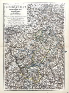
Sold2022Original Antique Map -Hessen Nassau - Map of Furstenthum WaldeckAntique outline hand colored map from edition of Meyer’s world atlas, edited by Ludwig Ravenstein, published by Bibliographic Institute in 1872. Technique: Engraving. Place: Leipzig, Germany. SSee Sold Price
Sold2022Original Antique Map - Konicreich Bohmen - Map of Bohmen - Prague - CarlsbadAntique outline hand colored map from edition of Meyer’s world atlas, edited by Ludwig Ravenstein, published by Bibliographic Institute in 1872. Technique: Engraving. Place: Leipzig, Germany. SSee Sold Price
Sold2022Antique Map Print of Oceania - Map of Madeira & The Azores - 1870 - James CookOriginal Antique Decorative Map of Madeira & The Azores, Fullarton, C.1870 This fascinating folio engraving is from Captain James Cook & James King's "A Voyage to the Pacific Ocean, for making DiscoveSee Sold Price
7 days LeftJasper52The flight into Egipt -Original antique engraving after G Freman, 17th century.$65
Featured7 days LeftJasper52Saint Paul cures the lame man - Original antique engraving after G Freman, 17th century.$80
Featured7 days LeftJasper52The Salutation of the Blessed Virgin - Original antique engraving after G Freman, 17th century.$80
Featured7 days LeftJasper52The marriage in Cana - Original antique engraving after G Freman, 17th century.$80
2 days LeftTrillium Antique Prints & Rare BooksSanson - Map of the Philippines and Ladrones Islands$75
2 days LeftTrillium Antique Prints & Rare BooksSanson - Map of the Sunda Islands, Sumatra, Java, & Borneo$75
May 30NY Elizabeth M. HANSIZ'S 1727 GERMANIA SACRA BLINDSTAMPED PIGSKIN ANTIQUE FOLIO WITH MAP$50(1 bid)
Jun 12Dan Morphy AuctionsINDIAN TERRITORY - DEPARTMENT OF THE INTERIOR GENERAL LAND OFFICE, C.1883$100


![L'America Meridionale. South America. DE ROSSI / SANSON 1677 old antique map: Title: L'America Meridionale. South America. DE ROSSI / SANSON 1677 old antique map Description: L'America Meridionale [South America] by Published by Giovanni Giacomo de Rossi. G. Sansone, Giorgio Wi](https://p1.liveauctioneers.com/5584/299901/159842128_1_x.jpg?height=310&quality=70&version=1693338270)