Sold2017Mitchell: Map of World in Hemispheres, 18601860 Mitchell World in Hemispheres. 11 X 13 inches. Very desirable and antique map of the world in a stunning layout showing seven separate views with the longest rivers and their tributaries in eachSee Sold Price
Sold2022Nice 1860 map of Maine with full hand coloringVery nice vintage map of Maine with original hand coloring by county. Features signature floral border that makes Mitchell maps stand apart. Railroads clearly delineated and named. Shows coastal featuSee Sold Price
Sold2019Nice 1860 map of AfricaMap of Africa, Showing Its Most Recent Discoveries (with Inset of the Island of St. Helena). Full hand coloring. 1860 date; from 1866 Mitchell New General Atlas. Good impression. Foxed heavily in margSee Sold Price
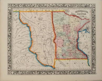
Sold20201860 Mitchell Map of Minnesota and the DakotasTitle/Content of Map: 1860 Mitchell Map of Minnesota and the Dakotas --Minnesota and Dacotah Date: 1860, Philadelphia Cartographer: S Mitchell Size: 10.6 X 13.3 in. This is a rather nice map of MinnesSee Sold Price
Sold20191860 Mitchell Map of Baltimore -- Plan of BaltimoreTitle: 1860 Mitchell Map of Baltimore -- Plan of Baltimore Date: 1860, Philadelphia Cartographer: S Mitchell Size: 9 X 11.2 in. Additional Information: A very nice map of Baltimore, identifying the vaSee Sold Price
Sold2018Mitchell: Antique Map of Indiana and Ohio, 1860Title/Content of Map: 1860 Mitchell Map of Indiana and Ohio -- County Map of Ohio and Indiana Date Printed: 1860 Philadelphia Cartographer: S Mithchell Size: 10.5 x 13.2 A very nice county map of OhioSee Sold Price
Sold2018Mitchell: Antique Map of Maine, 1860Title/Content of Map: 1860 Mitchell Map of Maine -- County Map of the State of Maine Date Printed: 1860, Philadelphia Cartographer: S Mitchell Size: 13.2 X 10.5 in. A very nice pastel color coded counSee Sold Price
Sold2023Excellent 1860 map of Baltimore by Samuel A. Mitchell, Jr.Nice example of Samuel Augustus Mitchell Jr’s map of Baltimore with the vivid outline hand coloring that sets this edition off from other editions. Shows wonderful detail at the street level, inSee Sold Price
Sold2017Mitchell: Antique Map of the World, 1840Title: Map of the World Maker: Samuel A. Mitchell Date: 1840 Dimensions (inches): 9.5 x 12 Medium: Hand Colored Engraving Good Condition Samuel Augustus Mitchell (1790-1860) was an American geographerSee Sold Price
Sold2019County Map of California, Mitchell 1860Lovely handcolored map of California during era of the Civil War. Published in the 1864 Mitchell General Atlas by S. Augustus Mitchell. Nice impression. Tiny water stain at lower left corner paper edgSee Sold Price
Sold2017Mitchell: Map of the United States & Territories, 1860Map: United States & Territories Maker: Mitchell Date: 1860 Size: 13.25 x 21.25 inches Condition: Some light soil marks in margin. Nice original hand coloring. Three very tiny spots in map. Very niceSee Sold Price
Sold2021Nice double-page map of New York, Mitchell 1860/66Title: Nice double-page map of New York, Mitchell 1860/66 Description: Impressive and colorful two-page map of the state of New York with inset maps of Buffalo, Rochester, Albany, and Troy. Hand colorSee Sold Price
Sold2018Pair Antique 19th Century Atlases, Bound MapsPair Antique 19th Century Atlases. ‘Mitchell’s New General Atlas Containing Maps of Various Countries of the World, Plans of Cities, Etc.’ published by S. Augustus Mitchell, Jr. c 1860. ‘AtlasSee Sold Price
Sold2018Pair Antique 19th Century Atlases, Bound MapsPair Antique 19th Century Atlases. ‘Mitchell’s New General Atlas Containing Maps of Various Countries of the World, Plans of Cities, Etc.’ published by S. Augustus Mitchell, Jr. c 1860. ‘AtlasSee Sold Price
Sold2019Map of Ore., Wash., Idaho & Montana, Mitchell 1860.Nice map of the northwestern states from Mitchell's 1864 New General Atlas published by S. Augustus Mitchell. One of the earliest maps to depict the new Territory of Montana (1864.) Maps from this perSee Sold Price
Sold2022Sharp “Plan of Cincinnati” by S. A. Mitchell, Jr. – 1860Very nice map depicts the City of Cincinnati and surrounding region in great detail. Numerous buildings such as the Post Office, Western Museum, Mayor’s Office, Mechanics Institute and U. S. HotSee Sold Price
Sold202319th C Hand Colored Map of State of Maine FRAMEDPublished by S.Augustus Mitchell, Jr. having a published date year of 1860. This hand colored map contains maps of the various countries of the world and plans of cities. Inset at lower right featuresSee Sold Price
Sold20191835 Hammond World Map -- The WorldTitle/Content of Map: 1835 Hammond World Map -- The World Cartographer: J Hammond Size: 11 x 17 in. A nice world map showing the Eastern and Western Hemispheres as well as polar projections and climatSee Sold Price
Sold20181886 Rand McNally World Map -- Map of the WorldTitle/Content of Map: 1886 Rand McNally World Map -- Map of the World Date: 1886, Chicago Cartographer: Rand McNally Size: 12.8 x 19.5 in. Very nice world map, offering details on topography and settlSee Sold Price
Sold20241895 Cram World Map -- The World on Mercator ProjectionTitle: 1895 Cram World Map -- The World on Mercator Projection Cartographer: G Cram Year / Place: 1895, Chicago Map Dimension (in.): 17 x 24.3 in. Very nice, larger world map, color-coding the countriSee Sold Price
Sold2024Augustus Mitchell 1860 Map Of TexasAugustus Mitchell 1860 Map Of Texas, Hand Colored Engravings On Paper, Sight 12 X 14 Inches, Later Frame 19 X 22 X 1 Inch, Paper Toned Especially At Edges By Mat, Not Examined Out Of Frame. See PhotosSee Sold Price
Sold20241860 Mitchell Map of US & Territories with Canada. Inset of Pensacola Bay & Hampton Roads / NorfolkTitle/Content of Map: 1860 Mitchell Map of US & Territories with Canada. Inset of Pensacola Bay & Hampton Roads / Norfolk Harbor. Date Printed: 1860 Cartographer: S. Augustus Mitchell Material/Medium:See Sold Price
Sold20211860 Mitchell Map of New Orleans -- Plan of New OrleansTitle: 1860 Mitchell Map of New Orleans -- Plan of New Orleans Cartographer: S Mitchell Year / Place: 1860, Philadelphia Map Dimension (in.): 9.2 X 11 in. This is a very an attractive map of the CrescSee Sold Price
Sold20201860 Mitchell Map of the Caribbean and Mexico -- Map ofTitle/Content of Map: 1860 Mitchell Map of the Caribbean and Mexico -- Map of Mexico Central America and the West Indies Cartographer: S Mitchell Year/Place: 1860, Philadelphia Size: 13.1 X 21 in. ThiSee Sold Price
1 day LeftJasper521881 Vuillemin World Map with French Colonies Shown -- Planisphere: Indiquant les Colonies Francises$30
4 days LeftHolabird Western Americana CollectionsSouth & Central America Map Lot c1800's [180163]$100
BonhamsMITCHELL (SAMUEL AUGUSTUS) A New Universal Atlas Containing Maps of the Various Empires, Kingdom...£1,300
Featured1 day LeftJasper521884 Johnson Map of Washington Oregon and Idaho -- Johnson's Washington Oregon and Idaho$100
BonhamsMITCHELL (SAMUEL AUGUSTUS) Mitchell's New General Atlas, Containing Maps of the Various Countrie...£500
6 days LeftWorthington Galleries19th c. Hemisphere World Map, Hohen und Tiefen der Erde in Lambert’s Zenithal-Projection von$10
3 days LeftActivity AuctionsRare 1976**Franklin Mint*Sterling Silver**925/Gold World Map Old Art Piece$1,100
2 days LeftJasper52Africa inc. discoveries of Livingstone Barth Vogel Chadda Exp. SWANSTON 1860 map$120
Jun 15Fine Arts OutletYoung Couple Reviewing a World Map Bronze Statue - Size: 32"L x 47"W x 42"H.$3,150


![South & Central America Map Lot c1800's [180163] (1 of 5)](https://p1.liveauctioneers.com/2699/331495/178785795_1_x.jpg?height=282&quality=70&version=1717094933)

![Map of Russia, Sweden, Norway, 1860 [180900] (1 of 1)](https://p1.liveauctioneers.com/2699/331495/178785784_1_x.jpg?height=282&quality=70&version=1717094933)


