Sold2019New Revised Follow the War World Map...Title: New Revised Follow the War World Map... Publication Date: c1942 Cartographer: WINSLOW, ROB'T/R.J. WALRATH Publisher: IDEAL DISTRIBUTING CO. Size: 27.8Height - 43.5Width Brightly colored wartimeSee Sold Price
Sold2017U.S. Army Atlas European Theater in World War IITitle: U.S. Army Atlas of the European Theater in World War II. Maps Created and Compiled by the Staff of the U.S. Army Center of Military History, Washington, D.C. New York. Barnes & Noble. 2004 AuthSee Sold Price
Sold2017Map of Principal Countries of the Ancient World, 1885Map: Map of the Principal Countries of the Ancient World From Black's General Atlas of the World New and Revised Edition. Edinburgh 1885 Size: 23.5 x 17.75 inches No Reserve: This lot starts at $1 andSee Sold Price
Sold2017Map of Atlantic Ocean Communication, 1885Map: Atlantic Ocean &c. Shewing the Communication Between Europe, North America and the Pacific From Black's General Atlas of the World New and Revised Edition. Edinburgh 1885 Size: 17.25 x 12.25 inchSee Sold Price
Sold2017Map of Celestial Hemispheres, 1885Map: Northern Celestial Hemisphere, Southern Celestial Hemisphere From Black's General Atlas of the World New and Revised Edition. Edinburgh 1885 Size: 17.25 x 12.25 inches No Reserve: This lot startsSee Sold Price
Sold2017Map of Victoria, 1885Map: Victoria From Black's General Atlas of the World New and Revised Edition. Edinburgh 1885 Size: 17.25 x 12.25 inches No Reserve: This lot starts at $1 and has no reserve as a courtesy so that collSee Sold Price
Sold2017Map of the Travels of St. Paul, Lower Egypt, 1885Map: The Countries embraced within the Travels of St. Paul, AND Lower Egypt From Black's General Atlas of the World New and Revised Edition. Edinburgh 1885 Size: 12.25 x 17.25 inches No Reserve: ThisSee Sold Price
Sold2017Map of Austria-Hungary, 1885Map: Austria-Hungary From Black's General Atlas of the World New and Revised Edition. Edinburgh 1885 Size: 23.5 x 17.75 inches No Reserve: This lot starts at $1 and has no reserve as a courtesy so thaSee Sold Price
Sold2017Map of German Empire East Sheet, 1885Map: German Empire East Sheet German Empire East Sheet From Black's General Atlas of the World New and Revised Edition. Edinburgh 1885 Size: 12.25 x 17.25 inches No Reserve: This lot starts at $1 andSee Sold Price
Sold2017Map of New South Wales, 1885Map: New South Wales From Black's General Atlas of the World New and Revised Edition Edinburgh 1885 Size: 12.25 x 17.25 inches No Reserve: This lot starts at $1 and has no reserve as a courtesy so thaSee Sold Price
Sold20181942 Turner Dated Events War Map -- Dated Events WarTitle/Content of Map: 1942 Turner Dated Events War Map -- Dated Events War Map Date Printed: 1942, New York Cartographer: S Turner Size: 17 x 38.8 in. This is a large world map, detailing the key evenSee Sold Price
Sold2022World.- Atlases.- Black (Adam and Charles) Black'sWorld.- Atlases.- Black (Adam and Charles) Black's General Atlas of The World, New and Revised Edition, frontispiece with flags of nations, title, and complete with 52 maps on 55 sheets (numbered 2-56See Sold Price
Sold20191945 Turner Dated Events War Map -- Dated Events WarTitle/Content of Map: 1945 Turner Dated Events War Map -- Dated Events War Map Cartographer: S TurnerDate: 1945, New York Size: 17 x 38.8 in. This is a large world map, detailing the key events towardSee Sold Price
Sold20211970 Humbead's Revised Map Of The World PosterThis rare 1970 edition of Humbead's Map of the World was not widely distributed. It includes approximately 250 new names not in the 1969 population list including Barbi Benton, Bernie Wrightson, BilboSee Sold Price
Sold2020Handy Shilling Atlas of The WorldTitle/Content of Map: Handy Shilling Atlas of The World Primary Authors: BARTHOLOMEW, J. G Date: c1905 Publisher: GEORGE NEWNES, LIMITED New revised edition. 12mo, 120,160 pp. col. maps (some doub. paSee Sold Price
Sold2022Buchanan, United States and World War Two, 1964 Vol. 1, illustrated"United States and World War Two," by Albert Russell Buchanan, with 14 maps and 16 pages of illustrations, published by Harper & Row, New York, 1964. This first volume covers the complex first periodSee Sold Price
Sold2019Fenning & Collyer 1765 Print. Native American Indians"A Sachem exhorting the Indians to War" Copper Plate Published 1764-65, London for "A New System of Geography: or, A General Description of the World" by Daniel Fenning & Joseph Collyer. Maps by G. RoSee Sold Price
Sold20241757 George Shelvocke "A Voyage Around the World by the Way of the Great South Sea"2nd revised edition Performed in a private expedition during the war, which broke out with spain in the year 1718 with 2 maps and illustrationSee Sold Price
Sold2018Lot of 8 Civil War era newspapers with front page MAPSLot of 8 issues (7 of The New York Herald and 1 of N.Y. World), various dates in 1861, 1862 ad 1864, featuring FRONT PAGE MAPS from Civil War battle locations. Oct. 13, 1861: Two maps: Locations at ChSee Sold Price
2022Blaeu, Johannes (Netherlands, 1596-1673) "The New World Map" Double Hemisphere World Map C. 1664Nova et Accuratissima Totius Terrarum Orbis Tabula Translated "The New World Map", Hand Colored w/ Elaborately Decorated Spandrels.   Sight View 16" x 21-1/2", Overall View 21" x 25-1/2"See Sold Price
Sold2019New World Map Jig-Saw PuzzleReserve Reduced! Title/Content of Map: New World Map Jig-Saw Puzzle Date: c1940 Material/Medium: H. M. Gousha Size: 26Height - 43Width Box title: New World Map Jig-Saw Puzzle / 8 colors / (size 43 in.See Sold Price
Sold2017Gabriel Tatton: The New World Map, 1600The New World Map 1600” drawn by Gabriel Tatton - reproduction by American Heritage, the magazine of history. Measurement approximate: 24” x 18”. Condition: Very Good Please note that this lSee Sold Price
Sold2017New Worlds, Maps from the Age of Discovery, 1st EdTitle: New Worlds. Maps from the Age of Discovery. London. Quercus. 2006 Author(s): Baynton-Williams, Ashley and Miles First edition. Condition: Fine copy in fine dust jacket (in mylar) Folio. Hard coSee Sold Price
Sold2016[Civil War; Map] History of the War [1864]Bishop, John S., Capt.: A CONCISE HISTORY OF THE WAR. DESIGNED TO ACCOMPANY PERRINE'S NEW WAR MAP OF THE SOUTHERN STATES.... Indianapolis. [1864]. 132, xi, [1] pp. plus large folding map. 5.75" x 3.75See Sold Price
2 days LeftRapid Estate Liquidators and Auction Gallery6 1980s 1990s National Geographic Magazines A$35
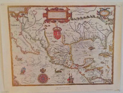
Jun 07Freeman's | Hindman[MAP]. ORTELIUS, Abraham. Americae Sive Novi Orbis, Nova Descriptio. 1573.$1,000(1 bid)
Jun 26The Buddha GalleryAntique Tibetan Thangka--intricate, - black ground - unique. Quite rare, fine and intense$1,750
3 days LeftEagles Corps International LLC(16) Civil War New Hampshire Veterans Medals and Ribbons$32(5 bids)
May 31Freeman's | Hindman[AFRICAN AMERICANA - WORLD WAR I]. Colored Man is No Slacker. Chicago, IL: E.G. Renesch, 1918.$250
16 hrs LeftJasper52WORLD WAR 2 Japanese occupied Philippines Malaya Indochina Thailand 1942 map$55(1 bid)
16 hrs LeftJasper52Asia political. Chinese Mongolia. French Indochina Japanese Korea TIMES 1922 map$10


![[Civil War; Map] History of the War [1864]: Bishop, John S., Capt.: A CONCISE HISTORY OF THE WAR. DESIGNED TO ACCOMPANY PERRINE'S NEW WAR MAP OF THE SOUTHERN STATES.... Indianapolis. [1864]. 132, xi, [1] pp. plus large folding map. 5.75" x 3.75](https://p1.liveauctioneers.com/3532/91776/46880401_1_x.jpg?height=310&quality=70&version=1469669287)


![[MAP]. ORTELIUS, Abraham. Americae Sive Novi Orbis, Nova Descriptio. 1573. (1 of 2)](https://p1.liveauctioneers.com/197/329395/177650534_1_x.jpg?height=282&quality=70&version=1715364962)


![[AFRICAN AMERICANA - WORLD WAR I]. Colored Man is No Slacker. Chicago, IL: E.G. Renesch, 1918. (1 of 1)](https://p1.liveauctioneers.com/197/329785/177758399_1_x.jpg?height=282&quality=70&version=1715625218)


