Sold2017National Geographic, large wall map of AsiaNational Geographic, large wall map of Asia, National Geographic Society (20th c.), "Asia", c. 1978, produced by the Cartographic Division National Geographic Society, 60.75"h x 53"w (sight), 62.25"hSee Sold Price
Sold2019Asia.- Clouet (Jean Baptiste Louis) Carte D'AsieAsia.- Clouet (Jean Baptiste Louis) Carte D'Asie Divisée en ses Principaux Etats, large wall map of Asia, with two title cartouches in French and Spanish, decorative borders containing twenty vigSee Sold Price
Sold2023Military Telegraph Lines Map - Philippines - Asia - National Geographic 1950sTitle/Content: Military Telegraph Lines Map - Philippines - Asia - National Geographic 1950s Date: 1950s Material: Paper Dimensions: 35” x 34” inches / 90 cm x 86 cm (х2) 35” xSee Sold Price
Sold2024National Geographic Maps 1940's and 1950's USA, Canada, Asia World MapNational Geographic Maps 1940's and 1950's USA, Canada, Asia World MapSee Sold Price
Sold2022Pub. 1958, Maps, "Atlas Folio", Publishd by National Geogrphic Society, Softcover, Extra large"Atlas Folio", Publisher: National Geographic Society, Publish Date: 1958, Illustrated with Maps, Extra Large Folio: H 19.5 " x W 14".See Sold Price
Sold20223 VOL. AROUND THE WORLD IN 125 YRS3 VOL. AROUND THE WORLD IN 125 YRS: Large National Geographic 3 Volume table books in original sleeves. Including; Asia/ Oceania, Europe / Africa, & The Americas / Antarctica. Approx. 15" h x 11.75" lSee Sold Price
Sold2020WYETH, N.C. Map of Discovery - Western HemisphereWYETH, N.C. "Map of Discovery - Western Hemisphere." Fifth of the series of five mural by N.C. Wyeth, the originals which adorn the walls of the National Geographic Society buildings.Washington: NatioSee Sold Price
Sold20211827 Thomson Map of Asia -- AsiaTitle: 1827 Thomson Map of Asia -- Asia Cartographer: J Thomson Year / Place: 1827, London Map Dimension (in.): 20.2 X 23.6 in. This is an excellent, large, double page map of Asia. The Great Wall ofSee Sold Price
Sold2019LARGE WALL MAP ULSTER COUNTY NEW YORKLARGE WALL MAP ULSTER COUNTY NEW YORK-OLIVER TILLSON, C. 1853 44" X 54"See Sold Price
Sold20201755 Large Wall Map of AfricaAfrica Performed by the Sr. Danville under the Patronage of the Duke of Orleans Revised and Improved by Mr. Bolton, a large map of Africa published in four sections, all present here, that can be combSee Sold Price
Sold20221889 LARGE WALL MAP of HOLY LAND to ILLUSTRATE BIBLE antique 52 by 60" antiqueLarge Wall Map of The Holy Land to Illustrate both the Old and New Testaments. Size 60 x 52 inches linen-backed and lacquered, wooden rollers; margins chipped, some soiling, generally sound. Made in ESee Sold Price
Sold20211844 Mitchell's National Wall Map of American Republic1844 Mitchell's National Wall Map of American Republic. These maps were issued between 1843 and 1850 by notable Philadelphia publisher S. Augustus Mitchell. Considered an important work of American caSee Sold Price
Sold2023Bowen, Thomas 1789 Large Map. Asia"A New & Accurate Map of Asia" Copper Engraved Map Published 1789-91 by C. Cooke, London for "The New Royal Encyclopedia, Or, Complete Modern Universal Dictionary of Arts and Sciences..." by William HSee Sold Price
Sold2021National Geographic Large Lot of Vintage Magazines206 Issues of Vintage National Geographic Magazine. Condition: VG-VFSee Sold Price
Sold2024Stanford, Edward 1901 Large Map. AsiaLarge Folio Lithograph Map Published 1901, London for "Stanford's London Atlas of Universal Geography" by Edward Stanford. Centre fold as published. Paper Size: 29 x 21.5 inch (74 x 55cm) Good ConditiSee Sold Price
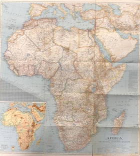
Sold2018National Geographic Map Africa 1943National Geographic magazine map for Africa . Date: 1943. Editor: Gilbert Grosvenor. Measurement approximate: 31 x 29. Shipping cost: $15.00See Sold Price
Sold2017Map Screen Of The United States National Geographic mapNational Geographic map of the U.S. divided into four section panels: east coast, Midwest, mountain states and west coast. West coast map missing. Panels are wood framed with plastic surfaces.See Sold Price
Sold2020Vintage National Geographic Map of AfricaDescription: Vintage color paper map from National Geographic Magazine depicts Africa. Some tearing on bottom. Map is copyrighted from 1943. Material: paper. Measurement: approximate 26.5"h x 34"w (INSee Sold Price
Sold2017National Geographic Map of Southwestern US Map, 1940The Southwestern United States map in the National Geographic Magazine dated June 1940. Measurement approximate: 26” x 35”. Condition: Very Good No Reserve: This lot starts at $1 and has no reservSee Sold Price
Sold2022(18) NATIONAL GEOGRAPHIC MAPS, c.1930s-1940s(lot of 18) National Geographic Maps, world maps dated late 1930s to 1940s, with many notes, mileage, and more, housed in book-form album, approx 10.75"h, 7.5"w, 2.25"d, 3.25lbs Start Price: $40.00See Sold Price
Sold2020(44)Vintage National Geographic Maps - Asst Regions(44)Vintage National Geographic Maps - Asst RegionsSee Sold Price
Sold2023135+ National Geographic Maps & 26 VHS Tapes135+ National Geographic Maps & 26 VHS TapesSee Sold Price
Sold2023Three National Geographic MapsThree National Geographic Maps, comprising one of the world, one of Japan and Korea, and one of China The largest: 38-1/4"h x 48-1/2"w overall; 31-1/2"h x 46-1/2"w sightSee Sold Price
7 days LeftHolabird Western Americana CollectionsTrinity County Mines (Wall) Map, 1894, Cowden, Johnson [177508]$250
5 days LeftJasper52Côte occidentale de l'Afrique. W Africa.Senegal Gambia rivers.D’ANVILLE 1751 map$85
2024Rapid Estate Liquidators and Auction Gallery6 1980s 1990s 2000s National Geographic Magazines JSee Sold Price
3 days LeftRapid Estate Liquidators and Auction Gallery6 1980s 1990s National Geographic Magazines A$35
6 days LeftHolabird Western Americana CollectionsCattle and Sheep Volumes (incl. NV) c1926-56 (4) [179378]$50
Jun 15Fine Arts OutletThe Arches National Park Picture on A Large Three-Piece Acrylic 1" x 78" x 39"H$580
5 days LeftJasper52Abstract "Tronic Artey" Artography Large Mixed-Media Sculpture by Pasqual Bettio$9,500
BonhamsSCOTTISH NATIONAL ANTARCTIC EXPEDITION, 1902-1904 [BROWN (ROBERT NEAL RUDMOSE, etc.) The Voyage ...£500
BonhamsBOTERO (GIOVANNI) Le relationi universali... novamente ristampate, & ricorrette -Aggiunta alla q...£5,000


![Trinity County Mines (Wall) Map, 1894, Cowden, Johnson [177508] (1 of 4)](https://p1.liveauctioneers.com/2699/331495/178785752_1_x.jpg?height=282&quality=70&version=1717094933)
![Jacob Monk 1853 Map of North America [173506] (1 of 11)](https://p1.liveauctioneers.com/2699/331495/178785775_1_x.jpg?height=282&quality=70&version=1717094933)


![Cattle and Sheep Volumes (incl. NV) c1926-56 (4) [179378] (1 of 10)](https://p1.liveauctioneers.com/2699/331494/178785467_1_x.jpg?height=282&quality=70&version=1717094654)


