Sold2023OVERSIZED REPRODUCTION OF A 16TH C. MAPMonumental and highly decorative offset lithograph reproduction map of the world by Giovanni Marfei after Abraham Ortelius, originally published c. 1589 or 1593. Dimensions: (Frame) H 45" x W 84" CondSee Sold Price
Sold2022Baedeker, Karl 1909 Lot of 46 Maps of Central Italy & RomeLithograph Maps Published 1909, Leipzig for "Central Rome and Italy. Handbook for Travellers" by Karl Baedeker. Folds as issued. Paper Size: Up to 13 x 11 inch (33 x 28cm) Good ConditionSee Sold Price
Sold2023Encyclo. Brit. 1898 Antique Map. Modern Rome, ItalyLithograph Map Published 1898, Edinburgh & London for "Encyclopaedia Britannica" Ninth Edition. Centre fold as issued. Paper Size: 15.5 x 10.5 inch (39 x 27cm) Good ConditionSee Sold Price
Sold2023Encyclo. Britannica 1885 Antique Map. RomeLithograph Published 1875-98, Edinburgh & London for "Encyclopaedia Britannica" Ninth Edition. Centre fold as published. Paper Size: 15 x 10.5 inch (38 x 27cm) Good ConditionSee Sold Price
Sold2023Baedeker, Karl 1893 Lot of 28 Maps. Central Italy & RomeLithograph Maps Published 1893, Leipzig for "Italy. Handbook for Travellers" by Karl Baedeker. Folds as issued. Paper Size: Up to 13 x 11 inch (33 x 28cm) Good ConditionSee Sold Price
Sold2023Nat. Encyclo. 1890's Mixed Lot of 10 Antique MapsIncl British Mining Maps, Plymouth Sound, Panama Canal, Charlemagne Empire, Carlovingian Empire, Rome Plan of the Forum, and The Projected Manchester Ship Canal. Lithograph Maps Published 1891-1901 bySee Sold Price
Sold2021Holy Land C1860 Lot of 4 Bible MapsIncl Travels of the Apostle Paul, The Countries between Jersusalem and Rome, Modern Palestine, and Palestine in the Time of Jesus Christ. Woodblock and Lithograph Maps Published C1860, London for "TheSee Sold Price
Sold2017Hand-Colored Lithograph Map of the Gulf of MexicoImpressive Hand-Colored Lithograph Map of the Gulf of Mexico, titled "U.S. Coast Survey, A.D. Bache Superintendent, Sketch H, Showing the Progress of the Survey in Section No. 8, 1846-1854", the map iSee Sold Price
Sold2022A.H. Jaillot - Monumental Map of AfricaAfrique Divisee en ses Principales Parties et ses Isles 49"x51" Paris, 1782, Framed 58x55x3.5See Sold Price
Sold20231926 Tony Sarg Colored Lithograph Map of Nantucket in the State of Massachusetts1926 Tony Sarg (1880-1942) Colored Lithograph Map of Nantucket in the State of Massachusetts, depicting founders of Nantucket Island and numerous landmarks, matted and framed Sight 16 in. x 18.5 in. OSee Sold Price
Sold2021Monumental Lithograph by Leroy Neiman "Moscow"Monumental lithograph by Leroy Neiman. (American 1921-2012) "Moscow Red Square" signed Lower Right and Numbered 248/375 Lower Left. Beautifully Framed. Condition: Excellent Condition. Dimensions: SighSee Sold Price
Sold2019Color lithograph map game of Europe, 1852Heading: (Games and puzzles) Author: Spooner, William Title: The Travellers of Europe; with improvements and additions Place Published: London Publisher:Published by William Spooner Date PublisheSee Sold Price
Sold2017Florida Lithograph MapU.S. Coast Survey Sketch F Showing the Progress of the Survey in Section V. A.D. Bache (1806-1867). Lithographed map. Washington, D.C., 1855. 23 x 16 1/2 inches visible, 27 1/4 x 21 1/2 inches framedSee Sold Price
Sold2023OSTERREICH Austria Travel Advertising Poster. Lithograph. Map of Austria with people in native ClothOSTERREICH Austria Travel Advertising Poster. Lithograph. Map of Austria with people in native Clothes. Printed in Austria. Dimensions: H: 30.5 inches: W: 21 inches --- US Shipping charge: $35 for theSee Sold Price
Sold2023Samuel A. Mitchell Hand Colored Lithograph MapSamuel Augustus Mitchell, American (1792-1868). Hand colored lithograph of Mexico, Central America, West Indies, 1860. Mounted in silver tone wood frame and includes paperwork. Measures 20"H x 27.75"WSee Sold Price
Sold2017Florida Lithograph MapA Plat Exhibiting The State of the Surveys in the State of Florida. US Surveyor General. Lithograph. Washington D.C. : 1855. 22 1/2 x 26 inches visible, 35 x 38 inches framedSee Sold Price
Sold2018Burleigh Lithograph Map 1890 Cleveland New YorkCleveland Village New York State, Burleigh, L. R. (Troy New York, 20th Century), circa 1890, lithograph on paper, publishing information and key printed in lower margin, image: 14 x 24, antiqued bronzSee Sold Price
Sold2019Burleigh Lithograph Map 1890 Cleveland New YorkCleveland Village New York State, Burleigh, L. R. (Troy New York, 20th Century), circa 1890, lithograph on paper, publishing information and key printed in lower margin, image: 14 x 24, antiqued bronzSee Sold Price
Sold2020Boston.4 folding lithograph maps, as listed below.Boston.4 folding lithograph maps, as listed below. First 2 folding into original 8vo printed wrappers (first detached); last with tears along several folds, generally clean and sound. Boston, vdBird'sSee Sold Price
Sold2017Five Lithograph Maps of the Lower MississippiFive U.S. Army Corps of Engineers Colored Lithograph Maps of the Lower Mississippi including two 1890s examples that chart the river improvements and levee lines from Lake Providence in Louisiana to tSee Sold Price
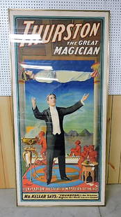
Sold2017Thurston the Great Magician - Levitation monumentalmonumental lithograph poster, 40" x 82", excellent vibrant colors and condition, extremely rare findSee Sold Price
Sold2023RARE BUCHOLTZ-LUDWIG ANTEBELLUM POCKET MAP OF VIRGINIARARE BUCHOLTZ-LUDWIG ANTEBELLUM POCKET MAP OF VIRGINIA, hand-colored lithograph, Map of the State of Virginia Containing the Counties, Principal Towns, Railroads, Rivers, Canals & All Other Internal ISee Sold Price
Sold2024Rare Civil War map: Bird's Eye View Seat of War, Prang, 1862BIRD'S EYE VIEW OF THE SEAT OF WAR, 1862, Civil War lithograph map published by Louis Prang & Co., Boston. Depicts key sites of the conflict including Washington, Baltimore, Harper's Ferry, Richmond,See Sold Price
3 days LeftWhite Knight Auction, IncBob Dylan, 'Sunset In The Mountain Valley', Limited Edition Litograph$200
3 days LeftJasper521760 Maire/Leclerk Map of Eastern Belgium and Liege -- Carte De La Principaute De Liege Et De Ses$500
Jun 02Gold Coast Auctioneers17th-19th c. French Wall Art Collection Map City Sea Scapes Scenes etc.$50
6 days LeftRbfineartsHistorical Map of the State of Kentucky by Karl Smith 1933 Daniel Boone & Companions View$30(2 bids)
Jun 08Simpson Galleries, LLC.JULIUS BIEN (1826-1909) AN AMERICAN CIVIL WAR RECONNAISSANCE MAP, "Map of Texas and Part of New$100
6 days LeftRbfineartsHistorical Map of the Chesapeake Bay By Edwin Tunis Published By The National Brewing Co.$20(1 bid)


![[MAP]. ORTELIUS, Abraham. Turcici Imperii Descriptio.1592. (1 of 2)](https://p1.liveauctioneers.com/197/329395/177650538_1_x.jpg?height=282&quality=70&version=1715364962)
![[MAP]. ORTELIUS, Abraham. Romani Imperii Imago. 1592. (1 of 2)](https://p1.liveauctioneers.com/197/329395/177650537_1_x.jpg?height=282&quality=70&version=1715364962)


