Sold2020WESTERN HEMISPHERE.Falls rivers mountains.No MtTITLE/CONTENT OF MAP: 'A comparative view of the principal waterfalls, islands, lakes, rivers and mountains in the Western Hemisphere' The Mississippi is indicated to be longer than the Amazon - neithSee Sold Price
Sold2017Map of Waterfalls Mountains etc. of Western HemisphereTitle/Content of Map: 'A comparative view of the principal waterfalls, islands, lakes, rivers and mountains in the Western Hemisphere' The Mississippi is indicated to be longer than the Amazon - neithSee Sold Price
Sold2023After Currier and Ives, "The City of New Orleans and the Mississippi River, Lake Pontchartrain inAfter Currier and Ives, "The City of New Orleans and the Mississippi River, Lake Pontchartrain in Distance," early 20th c., color lithograph, after the 1885 original, presented in a wood frame with aSee Sold Price
Sold2019After Currier and Ives, "The City of New Orleans andAfter Currier and Ives, "The City of New Orleans and the Mississippi River, Lake Pontchartrain in Distance," 20th c., print from the Fitzgerald Advertising Co., New Orleans, so identified verso, afterSee Sold Price
Sold2018Two Framed Prints of Civil War Battles Fort Pillow and8.5 X 10.5 AND 9.5 X 11.5Two Framed Prints. Island Number Ten April 7, 2862 shows Confederate control of the Mississippi River island. Fort Pillow Massacre, April 12, 1864 shows Union forces includingSee Sold Price
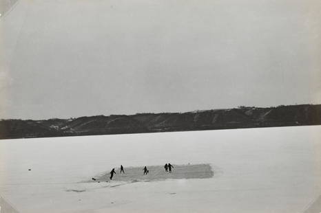
Sold2021JOHN VACHON - Skating on the Mississippi River nearTHIS LOT IS TO BE SOLD WITH NO RESERVE. Property from a distinguished Private Collection, New York ARTIST: John Vachon TITLE: Skating on the Mississippi River near Lake City, Minnesota, 1942 MEDIUM: FSee Sold Price
Sold20221862 John Pope Civil War Map Missouri BowenMap showing the System of Rebel Fortifications on the Mississippi River at Island No. 10 and New Madrid also The Operations of the U.S. Forces under General John Pope Against These Positions. "Bowen &See Sold Price
Sold2022(MISSISSIPPI RIVER.) John Ross. Course of the River Mississipi, From the Balise to Fort Chartres.(MISSISSIPPI RIVER.) John Ross. Course of the River Mississipi, From the Balise to Fort Chartres. Engraved folding map of the lower Mississippi River on two sheets joined. 44¾x15 inches sheet sizSee Sold Price
Sold20232 Vol's - Henry Rowe Schoolcraft American Travels 1821 & Muzzey's Civil WarTwo volumes, first being a published account of Henry Rowe Schoolcraft's travels through the American Great Lakes & Mississippi River, published 1821. A famous early American Geographer, Owner/OperatoSee Sold Price
Sold2020RAND MCNALLY & CO'S POCKET MAP AND SHIPPERS GUIDE TORAND MCNALLY & CO'S POCKET MAP AND SHIPPERS GUIDE TO ILLINOIS (showing the ) ENTIRE RAILROAD SYSTEM, post offices, islands, lakes, river, etc. 4x6.5” big fold out map. Copyright 1893. 95 railroaSee Sold Price
Sold2017Tallis: Map of W Hemisphere Mounts, Rivers, Lakes, 1850Map: 1850 Tallis Map of Western Hemisphere Mounts, Rivers, Lakes -- A Comparative View of the Principal Waterfalls, Islands, Lakes, Rivers and Mountains, in the Western Hemisphere Cartographer: J. TalSee Sold Price
Sold20227 Civil War Letters by Seth L. Phelps,most to his mother or father, 1862, from U.S. Gunboat "Benton", off Island #10, Mississippi River, near Cairo, Ill., some with very interesting content as per wartime life.See Sold Price
Sold2024Lake Superior and Mississippi River RR 1869 Seven Percent Bonds Book/Report-1869This is a Lake Superior and Mississippi River Railroad 1869 book/annual report that explains their offering of seven percent first class gold bonds for a total offering of $4.5 million. The railroad wSee Sold Price
Sold2019(3) PANORAMIC RPPC ADIRONDACKS & LAKE GEORGE. INCL.(3) PANORAMIC RPPC ADIRONDACKS & LAKE GEORGE. INCL. CASHVILLE, N.Y. ON THE SACANDOGA RIVER, THE NARROW AND HUNDRED ISLAND LAKE GEORGE, N.Y. & ELECTRIC POWER PLANT SACANDOGA LAKE & CONKLINGVILLE, N.Y.See Sold Price
Sold2022Lot 4 Vintage Assorted Small Paintings Old Barn etcLot 4 Vintage Assorted Small Paintings including Old barn Island in Lake, River and Old Farm. Measurements in inches: 10 x 8, 12 x 9, 6 x 14 and 15 x 23 Condition:Normal wear with age Shipping:We offeSee Sold Price
Sold2024Excellent 1875 RR map of Michigan, O. W. GrayNice map of lower Michigan, hand colored by counties and showing railroads, canals, post offices, stations, villages, coastal features, islands, bays, lakes, rivers, etc. One of the best commercial atSee Sold Price
Sold2021Nice map of SE coast of U. S. (Colton)Clean map of the southeast coast of the United States, with good detail. Shows railroad lines, towns, rivers, lakes, swamps, islands and coastal features. Inset of the Florida Keys. Full, original hanSee Sold Price
Sold2021[MAPS] A COLLECTION OF MAPS SOLD TOGETHER[MAPS] A collection of maps sold together, including: Bell, A. A NEW CHART OF THE RIVER ST. LAWRENCEFROM THE ISLAND OF ANTICOSTI TO LAKE ONTARIO. London: R. Baldwin, [1759]. Engraved map, 18 x 25 cm.See Sold Price
Sold20234 Currier & Ives Civil War LithographsFour 19th century Currier & Ives hand-colored lithographs on paper depicting Civil War battles. Titled "Bombardment of Island "Number Ten" in the Mississippi River", "Genl. Shields at the Battle of WiSee Sold Price
Sold20151867 Map of California and NevadaLeander Ransom & Amos Doolittle: A New Map of the States of California and Nevada, Exhibiting the Rivers, Lakes, Bays and Islands, with the principal Towns, Roads, Railroads and Transit Routes to theSee Sold Price
Sold2020Ansel Adams - Sierra Nevada, California 1923ANSEL ADAMS (B.1902-1984) Banner Park, Thousand Island Lake, Sierra Nevada, California 1923 Photo-litho 10" x 13" Printed second half of 20th CenturySee Sold Price
Sold2015America by Lotter, 1760 (California as Island)Copper engraving by Lotter, 1760. Significant pre-revolutionary map that features the idea of California as an island. Also, the British colonies are shown extending to the Mississippi River. UnframedSee Sold Price
Sold2015Noel Daggett, Apple River Island” oil on boardNoel Daggett, Apple River Island” oil on board mile 545 Mississippi river. Framed. Ca. 1960. 8”x10”.See Sold Price
Sold20221852 Owen Maps of Mississippi River from Minneapolis toTitle: 1852 Owen Maps of Mississippi River from Minneapolis to Upriver the Wisconsin -- Series of Sections on the Wisconsin River from the Mouth to Whitney's Rapids [on sheet with] Series of SectionsSee Sold Price
Jun 07Freeman's | HindmanHOMANN, Johann Baptist. Amplissimae Regionis Mississipi Seu Provinciae Ludovicianae. Nuremburg, [ca$400(1 bid)
Jun 23Schilb Antiquarian Rare Books1860 Voyages of Jonathan Carver INDIANS North America Mississippi Natchez Tours$1
1 day LeftJasper521625 Gerritsz Map of the Paraguay River Basin -- Paraguay, o Prov. de Rio de la Plata: me de$160
Jun 14Crescent City Auction GalleryAfter Marie Adrien Persac (French/Louisiana, 1823-1873), "Plantations on the Mississippi River from$325
Jun 08Tony Putty ArtifactsBook: Indian Pottery of the Mississippi River Valley by Roy Hathcock$20(1 bid)
Jun 09Heartland Artifact Auctions Inc8" x 10" Large Incised Pottery Jar featuring Fish Scales, Arcaded Handles, Minor restoration. Type$10(1 bid)
2 days LeftWhite Knight Auction, IncHiroshi Sugimoto, Aerial View Of Go-Oh Shrine, Naoshima Island, 2002$100


![[MAPS] A COLLECTION OF MAPS SOLD TOGETHER: [MAPS] A collection of maps sold together, including: Bell, A. A NEW CHART OF THE RIVER ST. LAWRENCEFROM THE ISLAND OF ANTICOSTI TO LAKE ONTARIO. London: R. Baldwin, [1759]. Engraved map, 18 x 25 cm.](https://p1.liveauctioneers.com/1124/208511/106199202_1_x.jpg?height=310&quality=70&version=1624388585)


![1852 Owen Maps of Mississippi River from Minneapolis to: Title: 1852 Owen Maps of Mississippi River from Minneapolis to Upriver the Wisconsin -- Series of Sections on the Wisconsin River from the Mouth to Whitney's Rapids [on sheet with] Series of Sections](https://p1.liveauctioneers.com/5584/234329/121339920_1_x.jpg?height=310&quality=70&version=1643151143)


