Sold2020Maryland & Delaware. With population by county chartTitle: Maryland & Delaware. With population by county chart and population by decade chart of Maryland. 1850 by Thomas Date/Period: c1850. Materials: Hand colored steel engraved Size: 16 1/2 x 13 1/2See Sold Price
Sold20191876 Mitchell Map of Virginia, West Wirginia [verso]Title/Content of Map: 1876 Mitchell Map of Virginia, West Wirginia [verso] New Jersey, Maryland, Delaware -- County Map of Virginia and West Virginia [verso] County Map of New Jersey [and] County MapSee Sold Price
Sold2021Laurie and Whittle Antique MapLaurie and Whittle Antique Map , "A New and General Map of the Middle Dominions Belonging to the United States of America, viz. Virginia, Maryland, the Delaware-Counties, Pennsylvania, New Jersey...",See Sold Price
Sold20181766 British Colonies MapHigh Quality Color Printed Map on heavy paper circa 1970's A General Map of the Middle British Colonies, in America. containing Virginia, Maryland, the Delaware Counties, Pennsylvania and New Jersey.See Sold Price
Sold2020Large Map of PennsylvaniaMap of Pennsylvania With map of New Jersey [and] Maryland Delaware and Baltimore County on versos Cartographer: George Franklin Cram Dated: Circa 1900See Sold Price
Sold2017Thomas Kitchin, Maryland and Scotland maps(Scottish, 1718-1784)., "Map of Maryland with the Delaware counties and the southern part of New Jersey," hand colored map, circa 1750, 7 x 9 in. , framed and "Scotland," circa 1760, 7 1/2 x 9 in. , fSee Sold Price
Sold2022Vintage RR map of Maryland & Delaware, 1850Excellent 1850 map of Maryland and Delaware with a chart of Chesapeake Bay Steamboat Routes. Published a decade before the Civil War and during an explosion in the country's railroad routes, the map aSee Sold Price
Sold2017Mitchell: Antique Map of New Jersey Delaware MarylandTitle/Content of Map: 1870 Mitchell: New Jersey, Delaware and Maryland -- County Map of Maryland and Delaware [on Sheet with] County Map of New Jersey Date Printed: 1870, Philadelphia Cartographer: SSee Sold Price
Sold2020New Jersey. With charts showing distances, countyTitle: New Jersey. With charts showing distances, county population and population by decades. 1850 by Thomas. Date/Period: c1850. Materials: Hand colored steel engraved Size: 16 1/2 x 13 1/2 inches.See Sold Price
Sold2022Sharp map of Delaware & Maryland, Johnson & Ward 1864Nicely detailed map of Delaware and Maryland showing counties, towns, waterways and railroads. Contains a text box explaining the origin of the Mason and Dixon line. Highly detailed map showing theseSee Sold Price
Sold2021County Map of the States of Delaware, Maryland,Publication Date: c1887 Title: County Map of the States of Delaware, Maryland, Virginia And West Virginia Cartographer: BRADLEY Publisher: BRADLEY & COMPANY Good atlas map with two small insets. On reSee Sold Price
Sold2018County Map of the States of Delaware, Maryland,Reserve Reduced! Title: County Map of the States of Delaware, Maryland, Virginia And West Virginia Publication Date: 1886 Cartographer: MITCHELL, S. AUGUSTUS, JR. Publisher: BRADLEY & BRO. Size: 14.5See Sold Price
Sold2021Mitchell: Maryland & Delaware / New Jersey, 1870Title/Content of Map: Mitchell: Maryland & Delaware / New Jersey, 1870 Date Printed: 1870, Philadelphia Cartographer: S. A. Mitchell Size: 14" x 11 1/2" Two well detailed and colored county maps, oneSee Sold Price
Sold2019Eight (8) Augustus Mitchell MapsCollection of eight maps including New Jersey/Maryland Delaware 1872, Two north and South Carolina 1872 maps (15" x 12"), Minnesota 1890 , Florida and the Carolinas 1860, County map of the state of ArSee Sold Price
Sold2022FRAMED MAP OF DELAWARE & MARYLAND (& DC)"Johnson's Delaware and Maryland" by A. J. Johnson, 1860, published in NYC. Hand colored engraving. Includes vignette map of "Washington City", giving an 1850 population of 29,815 Whites, 8,073 Free CSee Sold Price
Sold2019Samuel Augustus Mitchell (1790-1868), "County Map ofSamuel Augustus Mitchell (1790-1868), "County Map of Pennsylvania, New Jersey, Maryland and Delaware," 1860, hand colored, H. -12 3/4 in., W. - 15 3/8 in.See Sold Price
Sold2020Arkansas. With detailed population chart of towns andTitle: Arkansas. With detailed population chart of towns and counties. 1850 by Thomas Date/Period: c1850. Materials: Hand colored steel engraved Size: 16 1/2 x 13 1/2 inches. c1850 by Thomas, CowperthSee Sold Price
Sold2021Colton's Pennsylvania Virginia Delaware and MarylandTitle: Colton's Pennsylvania Virginia Delaware and Maryland Cartographer: JOHNSON & BROWNING Publisher: JOHNSON & BROWNING Size: 17.1 X 23.75 Pastel map showing counties separately colored, towns, towSee Sold Price
Sold2017Johnson's Delaware and MarylandMap: Johnson's Delaware and Maryland Description: A map of these two mid-Atlantic states with plenty of topographical and settlement details as well as showing roads and railroads. Counties are colorSee Sold Price
Sold2022Delaware County Morris Chair Rose Valley Design c1910Delaware County Morris Chair Rose Valley Design c1910. Although made almost exactly like a Rose Valley Morris Chair, this chair was most likely made by a local Craftsman copying a Rose Valley Morris CSee Sold Price
Sold2022Five Hohokam vessels and a stand from a hoard in Delaware County, Oklahoma, USA, circa 750 - 1500Five Hohokam vessels and a stand from a hoard in Delaware County, Oklahoma, USA, circa 750 - 1500 A.D.Three jugs of different shapes. A spherical pot and a decorated two-handled pot. Accompanied by aSee Sold Price
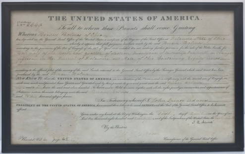
Sold2023Signed By US President John Quincy Adams 1825 American Land Grant Delaware County OHTitle:1825 American Land Grant Signed By US President John Quincy Adams Description: Framed 1825 Land Grant signed by then-President John Quincy Adams to a one Hiram Holmes of Delaware County, OH forSee Sold Price
Sold20184 3/8" Bannerstone labeled Delaware County, OHOut of the Robert Warrenberg Collection Collected from the mid to late 1900’sSee Sold Price
Sold2015Maryland, Delaware & PennsylvaniaA rare map of Maryland, Delaware & Pennsylvania that pre-dates Delaware as a state. Delaware is shown as part of New Jersey. Map also features Lord Fairfax's Boundary, Fort and Ohio Company, Great WagSee Sold Price
Jun 08Tony Putty Artifacts4 7/8" Dovetail. White to Gray Flint Ridge. Delaware Co, OH. Rogers COA.$215(2 bids)
Jun 08Tony Putty Artifacts4 7/16" Dovetail. White and Tan Flint Ridge. Delaware Co, OH. Rogers COA.$50
Jun 08Early American History Auctions1768 Principio Company, First Ironworks in (Cecil County) Maryland, Rare First Bill of Exchange$2,400
2 days LeftRapid Estate Liquidators and Auction GalleryVintage Young American Patriots World War II$75
Jun 08Holabird Western Americana CollectionsMaryland Indenture Doc Colonial Settlers c1764 [181008]$75
2 days LeftRapid Estate Liquidators and Auction Gallery4 Compact Discs Garth Brooks LeAnn Rimes Bonnie Raitt$20


![1876 Mitchell Map of Virginia, West Wirginia [verso]: Title/Content of Map: 1876 Mitchell Map of Virginia, West Wirginia [verso] New Jersey, Maryland, Delaware -- County Map of Virginia and West Virginia [verso] County Map of New Jersey [and] County Map](https://p1.liveauctioneers.com/5584/138985/70465971_1_x.jpg?height=310&quality=70&version=1554250661)


![Large Map of Pennsylvania: Map of Pennsylvania With map of New Jersey [and] Maryland Delaware and Baltimore County on versos Cartographer: George Franklin Cram Dated: Circa 1900](https://p1.liveauctioneers.com/5614/183569/92295179_1_x.jpg?height=310&quality=70&version=1603822607)


![Mitchell: Antique Map of New Jersey Delaware Maryland: Title/Content of Map: 1870 Mitchell: New Jersey, Delaware and Maryland -- County Map of Maryland and Delaware [on Sheet with] County Map of New Jersey Date Printed: 1870, Philadelphia Cartographer: S](https://p1.liveauctioneers.com/5584/111364/57183768_1_x.jpg?height=310&quality=70&version=1509054701)


![Maryland Indenture Doc Colonial Settlers c1764 [181008] (1 of 0)](https://p1.liveauctioneers.com/dist/images/placeholder.jpg?height=282&quality=70)

![Columbia Saloon Token, Very Rare [182130] (1 of 2)](https://p1.liveauctioneers.com/2699/331499/178846444_1_x.jpg?height=282&quality=70&version=1717095214)


