Sold2022Maryland and Delaware 1862 by Johnson and WardTitle: Maryland and Delaware 1862 by Johnson and Ward Date/Period: 1862 Materials: Steel plate engraved Size: 19" x 14" 1862 from 'Johnson's New Illustrated Family Atlas' By Johnson and Ward. PublisheSee Sold Price
Sold2019Two Maps by Johnson & Ward, "Delaware and Maryland,"Two Maps by Johnson & Ward, "Delaware and Maryland," 1862, hand colored, H.- 13 1/2in., W.- 17 1/4 in.; together with "Map of the Vicinity of Richmond and Peninsular Campaign in Virginia," 1862, handSee Sold Price
Sold2022Sharp map of Delaware & Maryland, Johnson & Ward 1864Nicely detailed map of Delaware and Maryland showing counties, towns, waterways and railroads. Contains a text box explaining the origin of the Mason and Dixon line. Highly detailed map showing theseSee Sold Price
Sold2019Two Copies of Johnson & Ward, "Delaware and Maryland,"Two Copies of Johnson & Ward, "Delaware and Maryland," 1855, hand colored, H.- 13 1/2 in., W.- 17 3/4 in. (2 Pcs.)See Sold Price
Sold2022Virginia, Pennsylvania, Delaware, and Maryland, 1862 byTitle: Virginia, Pennsylvania, Delaware, and Maryland, 1862 by Johnson and Ward Date/Period: 1862 Materials: Steel plate engraved Size: 19" x 27" 1862 from 'Johnson's New Illustrated Family Atlas' BySee Sold Price
Sold2020Maryland & DelawareTitle/Content of Map: Maryland & Delaware Date: 1863 Cartographer: By Johnson & Ward. From, Johnson’s New Illustrated Family Atlas Size: 18 x 13 1/2” Provenance: New York. Additional Info: Hand coSee Sold Price
Sold20201861 Maryland & Delaware. By JohnsonTitle: 1861 Maryland & Delaware. By Johnson Date/Period: 1861 Materials: Steel engraved. Size: 17 x 12 1/2” 1861. By A. J. Johnson & J. H Colton. From "Johnson's New Illustrated Family Atlas' publisSee Sold Price
Sold2019Scarce 1862 Neb/Dak/Col/Kans - Johnson & WardReserve Reduced! One of the rarest and most desirable states of Johnson's Dakota, Nebraska and Kansas map. In this example Nebraska is drawn with a long panhandle extending from Iowa all the way to FrSee Sold Price
Sold2022Dakota’s and Minnesota. 1862, Johnson and WardTitle: Dakota’s and Minnesota. 1862, Johnson and Ward Date/Period: 1862 Materials: Steel plate engraved Size: 19" x 14" 1862 from 'Johnson's New Illustrated Family Atlas' By Johnson and Ward. PuSee Sold Price
Sold2022Title page. 1862. Johnson and WardTitle: Title page. 1862. Johnson and Ward Date/Period: 1862 Materials: Steel plate engraved. Size: 19" x 14" 1862 from 'Johnson's New Illustrated Family Atlas'. By Johnson and Ward. Published in New YSee Sold Price
Sold20241862 Civil War-era map of Alabama/Georgia, Johnson & WardJohnson’s Georgia and Alabama from the 1862 edition of Johnson’s Family Atlas published during the second year of the war in 1862 by Johnson & Ward. Shows railroads operating at the beginnSee Sold Price
Sold2018Johnson: Antique Map of Maryland & Delaware, 1863Title/Content of Map: 1863 Johnson Map of Maryland and Delaware -- Johnson's Delaware and Maryland Date Printed: 1863, New York Cartographer: A Johnson Size: 12.5 x 15.8 in. A very nice map of these tSee Sold Price
Sold2019Johnson’s North America, Johnson & Ward, 1862Interesting configuration of North America, particularly the United States, Canada and Mexico, just after the outbreak of the Civil War. States roughly follow the 1861 configuration with archaic bordeSee Sold Price
Sold2022North America, 1862 by Johnson and WardTitle: North America, 1862 by Johnson and Ward Date/Period: 1862 Materials: Steel plate engraved Size: 19" x 27" 1862 from 'Johnson's New Illustrated Family Atlas' By Johnson and Ward. Published in NeSee Sold Price
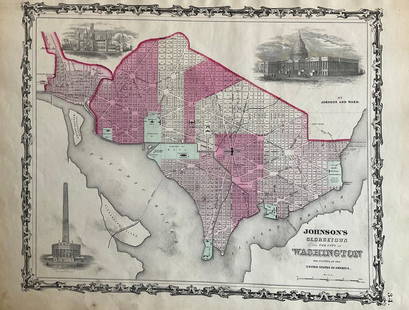
Sold2022Washington D.C. 1862 by Johnson and WardTitle: Washington D.C. 1862 by Johnson and Ward Date/Period: 1862 Materials: Steel plate engraved Size: 19" x 14" 1862 from 'Johnson's New Illustrated Family Atlas' By Johnson and Ward. Published in NSee Sold Price
Sold2016Johnson's Delaware & Maryland, 1861Map: Johnson's Delaware and Maryland Cartographer: Johnson & Browning Publishing: New York, 1861 Size: 12.3 x 16.3 inches A highly detailed map with topographical, city / town, and rail road details.See Sold Price
Sold2022New York. 1862. By Johnson and WardTitle: New York. 1862. By Johnson and Ward Date/Period: 1862 Materials: Steel plate engraved Size: 19" x 27" With inserts of eight cities including New York City, Buffalo, and Albany among others. 186See Sold Price
Sold20241863 Johnson Map of Delaware and Maryland -- Johnson's Delaware and MarylandTitle: 1863 Johnson Map of Delaware and Maryland -- Johnson's Delaware and Maryland Cartographer: Johnson & Ward Year / Place: 1863, New York Map Dimension (in.): 12.5 x 15.8 in. This is a very nice mSee Sold Price
Sold2022Mexico, 1862 by Johnson and WardTitle: Mexico, 1862 by Johnson and Ward Date/Period: 1862 Materials: Steel plate engraved Size: 19" x 14" 1862 from 'Johnson's New Illustrated Family Atlas' By Johnson and Ward. Published in New York.See Sold Price
Sold2022North & South Carolina, insert of Charleston , 1862 by Johnson and WardTitle: North & South Carolina, insert of Charleston , 1862 by Johnson and Ward Date/Period: 1862 Materials: Steel plate engraved Size: 19" x 27" 1862 from 'Johnson's New Illustrated Family Atlas' By JSee Sold Price
Sold2022Cuba, Jamaica with inserts of Puerto Rico and Havana, 1862 by Johnson and WardTitle: Cuba, Jamaica with inserts of Puerto Rico and Havana, 1862 by Johnson and Ward Date/Period: 1862 Materials: Steel plate engraved Size: 19" x 14" 1862 from 'Johnson's New Illustrated Family AtlaSee Sold Price
Sold2022Austrian empire, Hungary, entire Balkans, 1862 by Johnson and WardTitle: Austrian empire, Hungary, entire Balkans, 1862 by Johnson and Ward Date/Period: 1862 Materials: Steel plate engraved. Size: 19" x 27" 1862 from 'Johnson's New Illustrated Family Atlas'. By JohnSee Sold Price
Sold2022Ireland, 1862 by Johnson and WardTitle: Ireland, 1862 by Johnson and Ward Date/Period: 1862 Materials: Steel plate engraved. Size: 19" x 14" 1862 from 'Johnson's New Illustrated Family Atlas'. By Johnson and Ward. Published in New YoSee Sold Price
Sold2022New Jersey, 1862 by Johnson and WardTitle: New Jersey, 1862 by Johnson and Ward Date/Period: 1862 Materials: Steel plate engraved Size: 19" x 14" 1862 from 'Johnson's New Illustrated Family Atlas' By Johnson and Ward. Published in New YSee Sold Price
2 days LeftFreeman's | Hindman[CIVIL WAR]. JOHNSON, Andrew (1808-1875). Two military commissions stamp signed ("Andrew Johnson")$300
Jun 08Simpson Galleries, LLC.AN AMERICAN CIVIL WAR ERA ATLAS, "Johnson's New Illustrated Family Atlas of the World with Physical$300
4 days LeftTremont Auctions19th century marriage certificates with photographs. 1) 1852 certificate of Thomas Johnson and$100(1 bid)
2 days LeftFreeman's | Hindman[CIVIL WAR - GETTYSBURG]. CDV of General John Henry Hobart Ward, KIA at Gettysburg. New York:$200
Jun 08Early American History Auctions1877 JULIA WARD HOWE American Abolitionist + Womans Vote Autograph Letter Signed MOURNING Stationary$350
2 days LeftFreeman's | Hindman[CIVIL WAR]. Photographer unknown. Tent Wards, Harewood Hospital near Washington, D.C. 1862-1865.$200
Jun 29JM Hobby Supply and Railroad Artifact AuctionsDelaware Lackawanna and Western RR Adams and Westlake Lantern$2,200(4 bids)
Jun 29JM Hobby Supply and Railroad Artifact AuctionsDelaware Lackawanna and Western RR Sessions Station Clock$400


![[CIVIL WAR]. JOHNSON, Andrew (1808-1875). Two military commissions stamp signed ("Andrew Johnson") (1 of 1)](https://p1.liveauctioneers.com/197/329785/177758348_1_x.jpg?height=282&quality=70&version=1715625218)


![[CIVIL WAR - GETTYSBURG]. CDV of General John Henry Hobart Ward, KIA at Gettysburg. New York: (1 of 2)](https://p1.liveauctioneers.com/197/329785/177758286_1_x.jpg?height=282&quality=70&version=1715625218)


![[CIVIL WAR]. Photographer unknown. Tent Wards, Harewood Hospital near Washington, D.C. 1862-1865. (1 of 2)](https://p1.liveauctioneers.com/197/329785/177758336_1_x.jpg?height=282&quality=70&version=1715625218)


