Sold2016Maps and views for Lechevalier's Voyage to TroyHeading: Author: Lechevalier, Jean Baptiste Title: Recueil des Cartes, Plans, Vues et Médailles, Pour Servir au Voyage de la Troade Place Published: Paris Publisher:Dentu Date Published: AnSee Sold Price
Sold20201802 Denon Atlas of Egypt Containing Maps, Views, etc.Title: 1802 Denon Atlas of Egypt Containing Maps, Views, etc. -- Planches du voyage dans la Basse et la Haute Egypte Date: 1802 c., Paris Cartographer: D-V Denon Size: 18.2 X 11.4 in. and lagest foldoSee Sold Price
Sold2023OUTHIER, Reginald (1694-1774). Journal d'un Voyage au Nord, en 1736 et 1737. Paris: Chez Piget andOUTHIER, Reginald (1694-1774). Journal d'un Voyage au Nord, en 1736 et 1737. Paris: Chez Piget and Durand, 1744. 4to (257 x 194 mm). Half-title, 16 engraved folding maps, plans and views. (Mostly margSee Sold Price
Sold2016[HAWAII & ALASKA RELATED] MISC. LOT OF PRINTScontaining various engravings from Cook's voyage and other 18th Century engravings of Hawaii and the West Indies, including several early maps of Hawaii, as well as views of Alaska and other NorthwestSee Sold Price
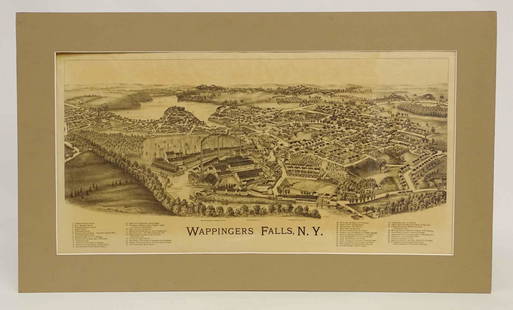
Sold2022Wappingers Falls New York Large ViewWappingers Falls, N.Y. Large Panorama Bird's-eye Map. L.R. Burleigh, Troy, New York, c. 1889. Antique print. 15" x 29".See Sold Price
Sold20211833 Discovery of AMERICA MAP Cabot Cartier Voyages1833 Discovery of AMERICA MAP Cabot Cartier Voyages Cook Vancouver Cortez Tytler Patrick Tytler’s “Historical View of the Progress of Discovery of America” is a rare, early 19th-century accountSee Sold Price
Sold2018San Francisco in Maps & Views Woodbridge Sally & RumseySan Francisco in Maps & Views. Woodbridge, Sally B. & David Rumsey. Rizzoli. First edition. Full number line. 4to. Illustrated in black, white and color. Important reference work. Please note that thiSee Sold Price
Sold20171773 Gentlemans Magazine Map Voyage South Seas Cpt CookFirst printing in original blue advertising wrapper of the Supplement issue of Gentleman's Magazine for the year 1773. Bound with the General Title and Preface and 26 pages, engraved folding plate shoSee Sold Price
Sold20231765 ATLAS MAPS & Voyages Pluche Geography Asia Arabia Greece America Egypt1765 ATLAS MAPS & Voyages Pluche Geography Asia Arabia Greece America Egypt Noël-Antoine Pluche was an early 18th-century French priest and historian who is most remembered today for his landmark wSee Sold Price
Sold20181785 ATLAS MAPS & Voyages Travel Geography Asia Arabia1785 ATLAS MAPS & Voyages Travel Geography Asia Arabia BEAUTIFUL Noël-Antoine Pluche was an early 18th-century French priest and historian who is most remembered today for his landmark work of naturaSee Sold Price
Sold2019Early European Map Views (10)Sebastian de Pontault, Knight of Beaulieu (1612? -1674). Plans and profiles of European cities. Engravings. Paris, late 17th Century. . 18 1/4" x 12".See Sold Price
Sold20211747 Map Voyage of Aeneas Described by VirgilAn engraved map "The Voyage of Aeneas as Described by Virgl", printed at London by John and Paul Knapton, 1747. Fine condition, measures 13.5 x 8". Reserve: $30.00 Shipping: Domestic: Flat-rate of $10See Sold Price
Sold2024Antique Map - Views on the coast of Asia. J. Webber del. Engraved after J. Webber and W. Bligh.Views on the coast of Asia. J. Webber del. (Engraved after J. Webber and W. Bligh. London, G. Nicol and T. Cadell, 1785). Author: Webber, John, 1751-1793; Bligh, William, 1754-1817; Cook, James, 1728-See Sold Price
Sold2019Map & view of Hawaii, c.1785Heading: (Hawaii) Author: Title: French map of the Hawaiian Islands & view of Karakakooa, framed together. Place Published: Paris Publisher: Date Published: c.1785 Description:See Sold Price
Sold20191780 HUGE CHINA MAP & Voyages Mandarin Chinese Theatre1780 HUGE CHINA MAP & Voyages Mandarin Chinese Theatre Military Funeral Procession The best book of its kind! A rare book La Harpe’s ‘General History of Voyages’! This extensive work was begun bSee Sold Price
Sold2017Rupprech/Haffner: Antique Map View of Geneva, 1740Title/Content of Map: 1740 Rupprech/Haffner View of Geneva -- Genf Date Printed: 1740 c. Augsburg Cartographer: MA Rupprecht / J C Haffner Size: 12 x 15.6 in. A rare "vue d'optique" (with mirror imageSee Sold Price
Sold2017Ierusalem - Panoramic Map View of Jerusalem, ProbablyIerusalem - Panoramic Map View of Jerusalem, Probably 18th Century. Following the map of Jacques Chereau (1688-1776) from the 18th century. Copperplate. Colored. 21x34cm.See Sold Price
Sold2017Mortier: Antique Map View of Biblical Desert, 1705Title/Content of Map: Detailed view of the wandering through the Desert. Biblical Date Printed: 1705-06 Cartographer: Pierre Mortier Material/Medium: Paper Size: 23 1/2" x 17 1/2" Copperplate engravedSee Sold Price
Sold2019Seneca Falls New York Map ViewBirds' Eye View of Seneca Falls, N.Y. 1873. Colored antique lithograph. Endicott & Co., New York. 22" x 27 3/4".See Sold Price
Sold2019France Antique Map & View, 17th C.Descriptio Veromanduorum, Antique map, Blaeu, Amsterdam, mid 17th C. W/ view Mommedy on 2 separate sheets, engraving by Israel Silvestre, 1669. 19 1/2" x 26 1/4".See Sold Price
Sold20231898 Walker Trolley Map & View of New England Center of BostonOriginal map Harvard Map Collection ca. 1905See Sold Price
Sold2020Italy 1747 Antique Map. View of Genoa, Ships"A View of the City of Genoa" Copper Plate Published 1732-85, London for "The London Magazine" Folds as issued. Paper Size: 11.5 x 8 inch (29 x 20cm) Good ConditionSee Sold Price
Sold2024Gentleman's Magazine 1757 Map & View of Fort Fouras, FrancceCopper Plate Published 1750, London for the "Gentleman's Magazine" Folds as issued. Paper Size: 8 x 5 inch (21 x 13cm) Good Condition overallSee Sold Price
Sold2022Algemeinen Welthistorie - History of the World, 4 Volumes, Johannes Salomon Semler, Halle,Algemeinen Welthistorie - History of the World, 4 Volumes, Johannes Salomon Semler, Halle, 1759-1761, with Maps, Views and more. Title: Uebersetzung der Algemeinen Welthistorie die in Engeland durch eSee Sold Price
1 day LeftTrillium Antique Prints & Rare BooksWebber & Cook, Rare - View of the Harbour of Taloo, in the Islands of Eimeo$500
1 day LeftTrillium Antique Prints & Rare BooksWebber & Cook, Rare - A Toopapaoo of a Chief, with a Priest Making His Offering to the Morai, in$500
1 day LeftTrillium Antique Prints & Rare BooksPrevost - Pair of Engravings of Views of Acapulco, Mexico$50
6 days LeftJasper52BLACK SEA Istanbul Odessa Sevastopol Sinop Varna views. TALLIS / RAPKIN 1860 map$40
5 days LeftUniversity ArchivesEarly Arctic Exploration: "Journal of a Voyage for the Discovery of a North-West Passage" by William$500
1 day LeftTrillium Antique Prints & Rare BooksBraun & Hogenberg, pub. 1575 - View of Bologna, Italy$100(1 bid)
1 day LeftTrillium Antique Prints & Rare BooksDavid Roberts - View from under the Portico of the Temple of Dendera$200
1 day LeftTrillium Antique Prints & Rare BooksBraun & Hogenberg, pub. 1575 - View of Basel, Switzerland$100
1 day LeftTrillium Antique Prints & Rare BooksBraun & Hogenberg, pub. 1575 - View of Limbourg, Belgium$100
1 day LeftTrillium Antique Prints & Rare BooksBraun & Hogenberg, pub. 1575 - View of Marseille, France$100
1 day LeftTrillium Antique Prints & Rare BooksBraun & Hogenberg, pub. 1575 - View of Haarlem, Netherlands$100
5 days LeftJasper521798 La Perouse Map of the Samoan Islands -- Chart of the Archipelago of Navigators…$110
6 days LeftJasper52EUROPE. Austrian Empire Prussia Poland. Slave market pic. RAPKIN/TALLIS 1851 map$100


![[HAWAII & ALASKA RELATED] MISC. LOT OF PRINTS: containing various engravings from Cook's voyage and other 18th Century engravings of Hawaii and the West Indies, including several early maps of Hawaii, as well as views of Alaska and other Northwest](https://p1.liveauctioneers.com/522/94826/48360052_1_x.jpg?height=310&quality=70&version=1476195147)