Sold2023Map Showing Durham-John Speed-Early 17th CenturyMap titled "The Bishopric and Citie of Durham" by John Speed and "to be sold by John Sudbury and Georg Humble" circa 1620's. Map was part of Speeds atlas "Theatre of the Empire of Great Britaine". SheSee Sold Price
Sold2023Map Showing Merionethshire, Wales-John Speed-Early 17th CenturyMap titled "Merionethshire. Described 1610" by John Speed and "to be sold by Georg Humble" circa 1620's. Map was part of Speeds atlas "Theatre of the Empire of Great Britaine". Sheet shows of map of MSee Sold Price
Sold2023Map Showing Anglesey-John Speed-Early 17th CenturyMap titled "Anglesey, Antiently Called Mona" by John Speed and "to be sold by John Sudbury and Georg Humble" circa 1610. Map was part of Speeds atlas "Theatre of the Empire of Great Britaine". Sheet sSee Sold Price
Sold2023Map Showing the Roman Empire-John Speed-Late 17th CenturyMap titled "A New Mappe of the Romane Empire" by John Speed and published by Bassett and Chiswell, circa 1676. Sheet shows map at center surrounded by vignettes of various cities and views of variousSee Sold Price
Sold202117th C. Map of Virginia: Nova Virginia TabulaImportant hand colored early map, the second state of the first published map made after John Smith's map of the area around the Chesapeake Bay. Notable in part for its vignettes showing Native AmericSee Sold Price
Sold2022JOHN SPEED 17TH C. MAP, AMERICA.John Speed map of the Americas, engraved with hand coloring, bordered on three sides with depictions of native peoples from Florida, Virginia, New England, and with city views including Havana, Cuzco,See Sold Price
Sold2022JOHN SPEED 17TH C. MAP, GREAT BRITAIN.John Speed map, ”The Kingdome of Great Britaine and Ireland,” engraved by J. Hondius, printed by Sudbury and Humble, London, 1610, with insets of London, Edinburgh, and the Orkney Islands,See Sold Price
Sold2022JOHN SPEED 17TH C. MAP, SPAIN.John Speed map, “Spaine Newly Described with Many Additions, both in the Attires of the People & the Setuations of their Cheifest Cityes” engraved map, hand-colored (likely later), bordereSee Sold Price
Sold2017Guillaume Blaeu: Map of Russia, Estonia to Moscow, 1660Russiae Vulgo Moscovia dictae Pars Occidentalis. By: Guillaume Blaeu Date: c. 1660 Dimensions: 19.25 x 15 in. (49 x 38.5 cm) This is an attractive early 17th century map showing the region of Russia fSee Sold Price
Sold20211660 Russiae Vulgo Moscovia dictae Pars OccidentalisBy: Guillaume BlaeuDate: 1660 (circa)Dimensions: 19.25 x 15 inches (49 x 38.5 cm)This is an attractive early 17th century map showing the region of Russia from Estonia to Moscow. Topographical featureSee Sold Price
Sold201517th C. John Speed, Huntington & Ely MapJohn Speed (British, 1552-1629), "Huntington, both Shire and Shire Town with the ancient citie Ely Described," hand colored, double engraved-page map originally created by noted cartographer, John SpeSee Sold Price
Sold202217TH-CENTURY JOHN SPEED BARKSHIRE DESCRIBED MAP17TH-CENTURY JOHN SPEED BARKSHIRE DESCRIBED MAP: Speed (John) Barkshire Described decorative cartouche, compass rose and costume figure, with large profile view of Windsor Castle, engraved map with orSee Sold Price
Sold2018Ortelius, Abraham. Insular. Aliquot Aegaei Mariscopperplate engraving with hand color from Theatrum Orbis Terrarum (Antwerp, early 17th century), showing a large inset map of Cyprus surrounded by smaller maps of the islands Delos, Ikaria, Rhodes, CSee Sold Price
Sold2022John SPEED: Two Antique Maps of IrelandTwo framed antique maps of Ireland by John Speed, a well known English cartographers circa 17th century. [Maps: 15" H x 20" W; Frames: 24" H x 28 1/2" W].See Sold Price
Sold2024JOHN SPEED ENGRAVED MAP "THE KINGDOME OF SCOTLAND" Britain, 17th Century 15" x 19.5" sight. FramedJOHN SPEED ENGRAVED MAP "THE KINGDOME OF SCOTLAND"Britain, 17th CenturyShows an inset of the "Yles of Orknay", and eight vignettes of Scottish commoners arranged in two panels.Titled in cartouche. DouSee Sold Price
Sold202417TH C. MAP OF THE BERKSHIRES BY JOHN SPEED, FRAMED"Barkshire Described", from the atlas of the same name, "Performed by I. Speed, P. Thomas Bassett in Fleet Street, Richard Chiswell in St. Paul's Churchyard, published in 1610, copperplate engraving oSee Sold Price
Sold2022Group of 14 Maps of Great Britain, Framed Celestial Map17th-19th century, engravings on laid or wove paper, all with hand colored highlights, comprising: John Speed, Darby Shire, London, circa 1630-1640, engraved by Peter Van Den Keere; John Owen & EmanueSee Sold Price
Sold201917th/18th map, Horowitz estateEarly black and white map, 17th/18th century. From the Milton Horowitz estate. Showing the coast of Italy. Map: 20"x 14.5" in a frame: 26.5"x 21".See Sold Price
Sold2022(5) ANTIQUE MAPS, MERCATOR & DE WITT, 17TH C.(lot of 5) Antique maps, early 17th c., published by Gerardus Mercator (Belgian, 1512-1594), likely from the "Mercator Hondius Atlas," published after his death c.1619, and Fredeick De Witt (Dutch, 16See Sold Price
Sold2022A large polychrome oak figure of John the Baptist, early 17th C.Full title: A large polychrome oak figure of John the Baptist, early 17th C. Description: H 79 cm Expert: Cabinet Benoit BertrandSee Sold Price
Sold202117th C Engraving of French Cardinals PopeA title leaf circa early 17th century showing a council of Cardinals gathering before the Pope titked "Gallia Purpurata", which tool place in 1245 at Paris. The leaf printed at Paris. Very Good, domeSee Sold Price
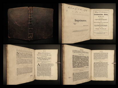
Sold20231690 Gunpowder Plot 1ed Anglican Overall Convocation Church England King James1690 Gunpowder Plot 1ed Anglican Overall Convocation Church England King James John Overall was an early 17th-century English Anglican bishop, most notably the dean of St. Pauls in London during the GSee Sold Price
Sold20231630 John Barclay Argenis Scottish Literature Elzevier Religion Wars Politics1630 John Barclay Argenis Scottish Literature Elzevier Religion Wars Politics John Barclay was an early 17th-century Scottish poet and author. His most important and well-remembered work was Argenis aSee Sold Price
Sold20231630 MAP OF TARTARY CHINA RUSSIA copper engraving ANTIQUEEarly 17th century map of Tartary, reduced from the larger edition of the map which appeared in the French Mercator-Jodocus Hondius Atlas Minor in the 1630s. Very fine and decorative engraving showingSee Sold Price
May 22Thomaston Place Auction GalleriesEARLY 17TH C. ELIZABETHAN ENGRAVED MAP OF CORNWALL BY WILLIAM KIP AFTER WILLIAM SAXTON$150
1 day LeftHermann Historica GmbHA large Russian icon showing Saint John the Forerunner, early 19th century€1,500(1 bid)
1 day LeftHermann Historica GmbHA large Russian icon showing Saint John the Forerunner from a Deesis, early 19th century€1,500
3 days LeftOriental Art AuctionsAL-IDRISI AND ROGER II, A MAP OF ASIA IN NUZHAT AL-MUSHTAQ, 17TH CENTURY€4,000
Jun 08Connoisseur AuctionsEarly 1900's Railway Service Map, Illinois, Ohio, Indiana, Kentucky, Tennessee$20
3 days LeftBonhamsAN EARLY-ENAMELLED SMALL JAR Edo period (1615-1868), mid-/late 17th century (2)£3,200
3 days LeftJasper52EUROPE showing daylight hours at summer equinox. Sunrise-sunset. MALLET 1683 map$40
2 days LeftBonhamsGeorge Leslie Hunter (British, 1877-1931) Still life with roses in a Chinese blue and white jar ...£32,000
2 days LeftJasper521671 MAP VENEZUELA CUM PARTE AUSTRALI NOUAE ANDALUSIAE antique 15x18" 17th CENT.$200
Jun 01Galerie Moenius AGEXTREMELY RARE RELIQUARY ICON WITH SILVER OKLAD AND INSET SILVER CROSS SHOWING THE CRUCIFIXION OF€5,000
May 23Templum Fine Art AuctionsGranada School of Pablo de Rojas Alcala La Real 15491611 Granada Bust of Saint John the Baptist€1,500


![John SPEED: Two Antique Maps of Ireland: Two framed antique maps of Ireland by John Speed, a well known English cartographers circa 17th century. [Maps: 15" H x 20" W; Frames: 24" H x 28 1/2" W].](https://p1.liveauctioneers.com/1221/264089/138965458_1_x.jpg?height=310&quality=70&version=1667576821)


![[MAP]. SPEED, John. A New Mappe of the Romane Empire. 1676. (1 of 2)](https://p1.liveauctioneers.com/197/329395/177650541_1_x.jpg?height=282&quality=70&version=1715364962)


![[POTTERY]. Pair of Rare Illustrated Jugs Plus a Rare Illust... (1 of 1)](https://p1.liveauctioneers.com/928/328184/176813309_1_x.jpg?height=282&quality=70&version=1714496988)


