Sold2022The World Illustrating the Principal Features of Meteorology [with] …Distribution and limitsTitle: The World Illustrating the Principal Features of Meteorology [with] …Distribution and limits of Cultivation of the Principal Plants… Cartographer: J Colton Year / Place: 1858, New YSee Sold Price
Sold20241863 Johnson Map of World Meteorology, and The Principal PlantsTitle: 1863 Johnson Map of World Meteorology, and The Principal Plants Cartographer: Johnson and Ward Year / Place: 1863, New York Map Dimension (in.): 15 X 10.1 in. This is a fascinating set of two mSee Sold Price
Sold20231858 Colton Map of Co-Tidal Lines [with] Ocean Currents and River Systems -- Map of the WorldTitle: 1858 Colton Map of Co-Tidal Lines [with] Ocean Currents and River Systems -- Map of the World Illustrating ... the Land & Co-Tidal Lines [on sheet with] Map of the World Showing ... Ocean CurreSee Sold Price
Sold2024Goode, George Brown 1884 Lot of 4 Natural History & Meteorology MapsIncl River Basins of the Atlantic Slope, World showing distribution on the Hair Seal Family, Ditto the Walruses/Seals/Sea Lions and Sea Elephants, and influence of Hydro-Thermals of the Migration of SSee Sold Price
Sold2019Scarce 1850 plants distributionScarce 1850 map or chart by Joseph Meyer depicting plant geography. Shows the distribution of vegetation throughout the world. Features five illustrations showing the vegetation in various regions, inSee Sold Price
Sold2021World's principal rivers comparative lengths. AmazonTITLE/CONTENT OF MAP: 'Plan of the lengths of the principal rivers throughout the world' The top image on the right hand side shows the entire map. To view a close up of the map showing the level of pSee Sold Price
Sold2021Dramatic map of greatest rivers & mountains, 1855Fascinating graphic map presentation showing the principal mountains and rivers in the World, with legends on either side identifying the rivers and mountains, including several active volcanoes. SpecSee Sold Price
Sold2019World map showing latest discoveries, 1778Heading: Author: Bowen, Thomas Title: The World including the late Discoveries by Captn. Cook and other Circum Navigators... Place Published: London Publisher: Date Published: [1778] DSee Sold Price
Sold2017Johnson: Map of the World On Mercator's ProjectionMap Title: Map of the World On Mercator's Projection Publisher: Johnson And Ward, Alvin Jewett Johnson Publishing Date: 1861 Size: Double Folio - 15.25 x 24.00 inches Large, Handsome world map showingSee Sold Price
Sold2018PanAM: Vintage Pictorial World Map, 1957Title/Content of Map: 1957 PanAM Pictorial World Map -- Your Clipper Cargo Market Area Date Printed: 1957 c. Cartographer: PanAm Size: 22 x 34 in. A very interesting world map showing PanAm cargo routSee Sold Price
Sold2019Rare 1st ed. map of world diseases, c1848World map showing the spread of diseases across the globe in mid-19th century. Three inset maps show diseases in North America, the spread of cholera throughout the world and South Africa. Charts andSee Sold Price
Sold2023WORLD MAP GOTHA JUSTUS PERTHESWorld Map showing the Roman World at its peak with insets of the world in Homers time (900 BC) from 19th c Atlas by Johan Georg Justus Perthes (1749-1812). Some foxing to top of map. Professionally frSee Sold Price
Sold20191955 Lockheed World Map adTitle/Content of Map: 1955 Lockheed World Map ad Date: 1955Cartographer: Lockheed Size: 13.6 X 21 in. when joined This is a fascinating world map showing the routes flown on Lckheed's Super ConstillatSee Sold Price
Sold2018John Glenn NASA Flight MapJohn Glenn NASA world map, showing first U.S. manned orbital flight. 1962 Souvenir Edition.See Sold Price
Sold20191835 Hammond World Map -- The WorldTitle/Content of Map: 1835 Hammond World Map -- The World Cartographer: J Hammond Size: 11 x 17 in. A nice world map showing the Eastern and Western Hemispheres as well as polar projections and climatSee Sold Price
Sold2018Two Large Maps of the WorldTwo Large Maps of the World, American Air Lines & Menier Chocolate. American Airlines Air World Map, showing the distances to various cities and locations from the geographical center of the United StSee Sold Price
Sold2019Lloyd's 1897 Lot of 8 World Natural History Maps8 World Maps showing the areas where Primates live. Chromolithographs Published 1894-97, London for "Lloyds's Natural History..." Edited by R. Bowdler Sharpe, W. F. Kirby, H. O. Forbes, R. Lydekker, aSee Sold Price
Sold2019Lloyd's 1897 Lot of 8 World Natural History Maps8 World Maps showing the areas where Primates live. Chromolithographs Published 1894-97, London for "Lloyds's Natural History..." Edited by R. Bowdler Sharpe, W. F. Kirby, H. O. Forbes, R. Lydekker, aSee Sold Price
Sold2023Late 19thc Map, Thalheimer's The World, Colonial PossessionsLate 19th Century, 1897, map of The World, Map XV, Showing Colonial Possessions by A von Steinwehr, from Thalheimer's Medieval and Modern History. 7 1/4" X 10 1/4".See Sold Price
Sold2022World.- Bordone (Benedetto di) [World Map], woodcut, [1522].World.- Bordone (Benedetto di) [World Map], early map showing the recent developments in cartography and departing from Ptolemaic models, including open water between the two continents and not joininSee Sold Price
Sold2022MID CENT HOWARD MILLER ELECTRIC WORLD TIME CLOCKA 1959 multi-time zone mantel or wall clock by Howard Miller Clock Co., Michigan, US. Model 612408 and 622339. The rectangular clock face represents a color world map with windows showing time in 70 pSee Sold Price
Sold2019Rare 1st ed. German world distribution, 1846World map in partial color showing the distribution of Germans throughout the world. Inset maps showing the specific spread of Germans in North America and South America. Inset shows Germans in NorthSee Sold Price
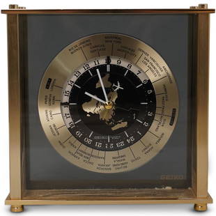
Sold2020Seiko World Desk ClockDESCRIPTION: A Seiko desk clock. Features a world map dial with white colored hands and airplane motif seconds hand. Marked "Seiko, Quartz Japan" Finished with time zone markers and a gilt brass case.See Sold Price
Sold2016Rare Vintage Map of Afghanistan War Rug: 5'9'' x 7'3''Rare Vintage Afghanistan War Rug showing map of world with Afghanistan at its center from refugee camp in Peshawar, Pakistan. 1997. Size: 5'9'' x 7'3'' (175 x 221 cm). An outstanding and large exampleSee Sold Price
Featured9 hrs LeftJasper521814 Aaron Arrowsmith map. Israelites from Egypt to Canaan through the desert of Arabia Petraea$130
2 days LeftSloans & KenyonMAP OF CONNECTICUT SHOWING PRINCIPAL HIGHWAYS, WITH ILLUSTRATIONS BY JOHN HELD JR AND HISTORIC$350
1 day LeftHannam's Auctioneers LtdThe Complete Atlas of Modern, Classical and Celestial Maps, together with Plans of the Principal Cit£240
1818 AuctioneersMaps. Atlas. The M.P. Atlas. A Collection of Maps Showing the Commercial and Political Interests£12(1 bid)
5 days LeftArarity AuctionsThomson's 1817 Hand Colored Map Comparative Heights of the World's Great Mountains$50
Jun 07Freeman's | Hindman[MAP]. ORTELIUS, Abraham. Americae Sive Novi Orbis, Nova Descriptio. 1573.$1,000(1 bid)


![The World Illustrating the Principal Features of Meteorology [with] …Distribution and limits: Title: The World Illustrating the Principal Features of Meteorology [with] …Distribution and limits of Cultivation of the Principal Plants… Cartographer: J Colton Year / Place: 1858, New Y](https://p1.liveauctioneers.com/5584/272286/142770664_1_x.jpg?height=310&quality=70&version=1671577913)


![1858 Colton Map of Co-Tidal Lines [with] Ocean Currents and River Systems -- Map of the World: Title: 1858 Colton Map of Co-Tidal Lines [with] Ocean Currents and River Systems -- Map of the World Illustrating ... the Land & Co-Tidal Lines [on sheet with] Map of the World Showing ... Ocean Curre](https://p1.liveauctioneers.com/5584/291311/154333687_1_x.jpg?height=310&quality=70&version=1685623945)


![World map showing latest discoveries, 1778: Heading: Author: Bowen, Thomas Title: The World including the late Discoveries by Captn. Cook and other Circum Navigators... Place Published: London Publisher: Date Published: [1778] D](https://p1.liveauctioneers.com/642/151690/76551227_1_x.jpg?height=310&quality=70&version=1570486555)


![World.- Bordone (Benedetto di) [World Map], woodcut, [1522].: World.- Bordone (Benedetto di) [World Map], early map showing the recent developments in cartography and departing from Ptolemaic models, including open water between the two continents and not joinin](https://p1.liveauctioneers.com/5458/252576/131355887_1_x.jpg?height=310&quality=70&version=1655911671)


![[MAP]. SPEED, John. A New Mappe of the Romane Empire. 1676. (1 of 2)](https://p1.liveauctioneers.com/197/329395/177650541_1_x.jpg?height=282&quality=70&version=1715364962)


![[MAP]. ORTELIUS, Abraham. Americae Sive Novi Orbis, Nova Descriptio. 1573. (1 of 2)](https://p1.liveauctioneers.com/197/329395/177650534_1_x.jpg?height=282&quality=70&version=1715364962)