Sold20231858 Colton Map of Co-Tidal Lines [with] Ocean Currents and River Systems -- Map of the WorldTitle: 1858 Colton Map of Co-Tidal Lines [with] Ocean Currents and River Systems -- Map of the World Illustrating ... the Land & Co-Tidal Lines [on sheet with] Map of the World Showing ... Ocean CurreSee Sold Price
Sold2020World land masses and tidal lines. World ocean currentsTitle: World land masses and tidal lines. World ocean currents and river system. By Johnson Date/Period: 1861 Materials: Steel engraved. Size: 18 x 13 1/2” By A. J. Johnson & J. H Colton. From "JohnSee Sold Price
Sold2018SDUK: Map of Asia & Australia on Gnomonic ProjectionTitle/Content of Map:'WORLD ON GNOMONIC PROJECTION, IV, Asia.' Cotidal lines are marked on the map. ASIA AUSTRALIA. On Gnomonic Projection. China Indian Ocean. Date Printed: 1846 Image Size: Approx 32See Sold Price
Sold2017SDUK: Map of Australasia Polynesia Pacific Ocean, 1846TITLE OF MAP (NOT PRINTED ON THE PAGE):'WORLD ON GNOMONIC PROJECTION, III., Polynesia' AUSTRALASIA POLYNESIA PACIFIC OCEAN. On Gnomonic Projection. Cotidal lines are marked on the map DATE PRINTED: 18See Sold Price
Sold20191870 Johnson Maps of Ocean Currents, River Basins andTitle/Content of Map: 1870 Johnson Maps of Ocean Currents, River Basins and Air Temperatures -- Johnson's Ocean Currents and the Great River Basins of the World [on sheet with] Johnson's World ShowingSee Sold Price
Sold20191870 Johnson Maps of Ocean Currents, River Basins andTitle: 1870 Johnson Maps of Ocean Currents, River Basins and Air Temperatures -- Johnson's Ocean Currents and the Great River Basins of the World [on sheet with] Johnson's World Showing the DistributiSee Sold Price
Sold2016World Map of Ocean Currents & Air Temperatures, 1867Original engraving from "New Illustrated Family Atlas of the World" published by A.J. Johnson, 1867. Wonderful original color. Great detail showing ocean currents and river basins of the world on uppeSee Sold Price
Sold2018McNally: Antique Chart Ocean Currents & Rain Fall, 1874Title/Content of Map: 1874 McNally Chart of the Ocean Currents and Rain Fall -- Ocean & Continental Basins, Ocean Currents and Co-Tidal Lines Date Printed: 1874 ca., New York Cartographer: F McNally SSee Sold Price
Sold2017Moll - Correct Map of the Whole World, 1719Herman Moll (1654?-1732), cartographer and publisher A New & Correct Map of the Whole World Shewing y.e Situation of its Principal Parts. Viz the Oceans, Kingdoms, Rivers, Capes, Ports, Mountains, WooSee Sold Price
Sold2023Jacob & Co WatchJacob & Co Five Time Zone Stainless Steel Bracelet Watch, Pave Set Diamond World Map Dial with Four Subsidiary Dials for Separate Time Zones. #S7091. Swiss quartz movement. Case measures 48mm. BraceleSee Sold Price
Sold2022JACOB & CO. FIVE TIME ZONE STAINLESS STEEL WATCHJACOB & CO. FIVE TIME ZONE STAINLESS STEEL WATCH (No Reserve*) Stainless steel case and bracelet. Dial with diamond world map and subsidiary dials for four separate time zones and the main dial for thSee Sold Price
Sold2022[MANUSCRIPT MAP-FLORIDA & MISSISSIPPI RIVER] Map Showing Raiford's Proposed Artificial River and[MANUSCRIPT MAP-FLORIDA & MISSISSIPPI RIVER] Map Showing Raiford's Proposed Artificial River and Plan to Continue the Western and Southern Inland System of Navigation to Harbors in the Atlantic. [FernSee Sold Price
Sold2022Color map of S.F. showing water system 1908Heading: -1908 Author: Title: Map of San Francisco showing its uneven territory and the present and proposed main conduits reservoirs and pumping plants of the Spring Valley Water Co. 1908 Place PublSee Sold Price
2021GREAT NORTHERN’S 2 GREAT TRAINS SYSTEM MAP.Huge dramatic reverse glass advertising Great Northern's two great trains, Empire Builder and Western Star. In script just below Great Northern logo it states "Steamliners twice a day, each way, betweSee Sold Price
2022Blaeu, Johannes (Netherlands, 1596-1673) "The New World Map" Double Hemisphere World Map C. 1664Nova et Accuratissima Totius Terrarum Orbis Tabula Translated "The New World Map", Hand Colored w/ Elaborately Decorated Spandrels.   Sight View 16" x 21-1/2", Overall View 21" x 25-1/2"See Sold Price
Sold1919 Map of European Russia1919 Map of European Russia: Map showing the lines held by the Soviet Army on June 5th 1919, done by N.R.E.F. Mapping Section, in folded condition, size 40 cm x 42 cm.See Sold Price
Sold2024De Fer Map of the Mississippi RiverDE FER, Nicolas (1646-1720). Partie Meridionale de la Riviere de Missipi, et ses environs, dans l'Amerique Septentrionale. Mis au jour par N. de Fer. Geographe de sa Majeste Catolique 1718. Engraved mSee Sold Price
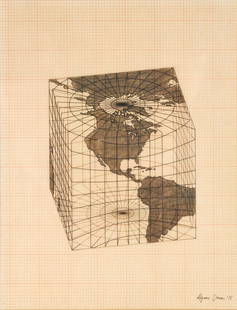
Sold2021Agnes Denes - Study of Distortions; Isometric SystemsLot 3 Agnes Denes Hungarian/American (b. 1931) Study of Distortions; Isometric Systems in Isotropic Space-Map Projections: The Cube (1975) gouache and ink on graph paper and mylar signed lower right sSee Sold Price
Sold2016T-O World Map.- Lucanus (Marcus Annaeus) Pharsalia,Lucanus (Marcus Annaeus) Pharsalia, manuscript on paper, [Northern Italy (possibly Padua), first half of the fifteenth century]. 294 x 217mm., I + 149 + I leaves (including defective leaves and 3 blanSee Sold Price
Sold2024Petrus Plancius, Engraved World MapOrbis Terrarum Typus de Integro Multis in Locis Emendatus. Petrus Plancius (1552-1622). Copper-plate engraving with original hand color in full. Amsterdam, 1594. Some stains, creases, folds. Sight sizSee Sold Price
Sold2024Large Nova Totvis Terrarum Orbis Gold Foil World MapLarge Nova Totvis Terrarum Orbis Gold Foil World Map, 24.5in by 30.5inSee Sold Price
Sold2016JOHN SPEED (BRITISH, 1552-1629) MAP OF THE WORLDJOHN SPEED (BRITISH, 1552-1629) MAP OF THE WORLD, (UPDATED 6/14/16) hand-colored engraving on laid paper, titled "A New and Accurat Map of the World Drawne according to ye truest Descriptions latest DSee Sold Price
Sold2018World Class Speckled Granite 2 9/16" Bust Birdstone -Found along the Scioto River in Ross Co., Ohio. Highly polishedblack and white mottled hardstone. Properly drilled. Also note secondary unfinished drilling on leading hole/edge. Superb condition. Ex-See Sold Price
Sold2024Thomson's 1817 Hand Colored Map Comparative Heights of the World's Great MountainsAntique hand-colored Thomson's 1817 Map of the Comparative Heights of the World's Great Mountains framed. Good sight condition, apparent repair upper middle right. Framed, matted, and sealed under pleSee Sold Price
Jun 14Crescent City Auction GalleryAfter Marie Adrien Persac (French/Louisiana, 1823-1873), "Plantations on the Mississippi River from$325
4 days LeftFreeman's | Hindman[POST-RECONSTRUCTION]. The South has United to make a Grand Exposition of Southern Products , in the$500
Jun 08Simpson Galleries, LLC.JULIUS BIEN (1826-1909) AN AMERICAN CIVIL WAR RECONNAISSANCE MAP, "Map of Texas and Part of New$100
5 days LeftNorthgate Gallery, Inc.Vintage Baker Furniture George II Style Wing Back Arm Chairs, Pair$200
Jun 07Freeman's | Hindman[RMS TITANIC]. White Star Line: Types of World Famous Liners. Liverpool: The Liverpool Printing &$1,000
3 hrs LeftDonny Malone AuctionsWorld Globe on Axis Mounted on Tall Base: Replogle "World Ocean Series" 31.5 in. height$20(2 bids)
Jun 09Austin Auction GalleryAMERICAN STERLING OVERLAY & BLOWN GLASS COUNTRY CLUB PRESENTATION PITCHER$300


![1858 Colton Map of Co-Tidal Lines [with] Ocean Currents and River Systems -- Map of the World: Title: 1858 Colton Map of Co-Tidal Lines [with] Ocean Currents and River Systems -- Map of the World Illustrating ... the Land & Co-Tidal Lines [on sheet with] Map of the World Showing ... Ocean Curre](https://p1.liveauctioneers.com/5584/291311/154333687_1_x.jpg?height=310&quality=70&version=1685623945)
![1858 Colton Map of Co-Tidal Lines [with] Ocean Currents and River Systems -- Map of the World First Image](https://p1.liveauctioneers.com/5584/289753/153469664_1_x.jpg?height=300&quality=1&version=1684878062&width=300)
![1858 Colton Map of Co-Tidal Lines [with] Ocean Currents and River Systems -- Map of the World First Image](https://p1.liveauctioneers.com/5584/289753/153469664_1_x.jpg?height=300&quality=95&version=1684878062&width=300)


![1870 Johnson Maps of Ocean Currents, River Basins and: Title/Content of Map: 1870 Johnson Maps of Ocean Currents, River Basins and Air Temperatures -- Johnson's Ocean Currents and the Great River Basins of the World [on sheet with] Johnson's World Showing](https://p1.liveauctioneers.com/5584/143145/72415294_1_x.jpg?height=310&quality=70&version=1559682291)
![1870 Johnson Maps of Ocean Currents, River Basins and: Title: 1870 Johnson Maps of Ocean Currents, River Basins and Air Temperatures -- Johnson's Ocean Currents and the Great River Basins of the World [on sheet with] Johnson's World Showing the Distributi](https://p1.liveauctioneers.com/5584/151513/76489204_1_x.jpg?height=310&quality=70&version=1570570843)


![[MANUSCRIPT MAP-FLORIDA & MISSISSIPPI RIVER] Map Showing Raiford's Proposed Artificial River and: [MANUSCRIPT MAP-FLORIDA & MISSISSIPPI RIVER] Map Showing Raiford's Proposed Artificial River and Plan to Continue the Western and Southern Inland System of Navigation to Harbors in the Atlantic. [Fern](https://p1.liveauctioneers.com/292/250642/130213644_1_x.jpg?height=310&quality=70&version=1654271664)


![T-O World Map.- Lucanus (Marcus Annaeus) Pharsalia,: Lucanus (Marcus Annaeus) Pharsalia, manuscript on paper, [Northern Italy (possibly Padua), first half of the fifteenth century]. 294 x 217mm., I + 149 + I leaves (including defective leaves and 3 blan](https://p1.liveauctioneers.com/5458/94966/48431616_1_x.jpg?height=310&quality=70&version=1476369049)


![[POST-RECONSTRUCTION]. The South has United to make a Grand Exposition of Southern Products , in the (1 of 3)](https://p1.liveauctioneers.com/197/329785/177758403_1_x.jpg?height=282&quality=70&version=1715625218)


![[RMS TITANIC]. White Star Line: Types of World Famous Liners. Liverpool: The Liverpool Printing & (1 of 1)](https://p1.liveauctioneers.com/197/329395/177650200_1_x.jpg?height=282&quality=70&version=1715364962)


