Sold2016Map of Massachusetts (inset of Boston), Martha'sOriginal engraving from Atlas of the World by Rand McNally, 1895. Map includes counties, geographical landmarks, streets and population data. Dimensions: 21 1/4" x 27 1/2" No Reserve This item ships fSee Sold Price
Sold2021Great RR map of Mass. & Rhode IslandFrom the Tanner/Mitchell/Cowperthwait atlas publishing tree comes this great railroad map of Massachusetts and Rhode Island. Features a large inset of Boston, including a list of building locations. TSee Sold Price
Sold2021Massachusetts and Rhode IslandPublication Date: 1856 Title: Massachusetts and Rhode Island Cartographer: COLTON, J.H. Publisher: J.H. COLTON & CO. Height: 11 Width: 15.5 Detailed map with inset of Vicinity of Boston. Shows countieSee Sold Price
Sold20164 Maps: Bradford (1838): Mass., CT, NJ, Boston.[United States/Northeast] 4 Maps. ++ MASSACHUSETTS. ++ BOSTON. ++ CONNECTICUT. ++ NEW JERSEY. ++ Maps 10, 11, 13, and 16 from T. G. Bradford, “An Illustrated Atlas, Geographical, Statistical, And HiSee Sold Price
Sold20221878 HUGE MAP of Massachusetts & Boston Harbor Rand McNally Plymouth1878 HUGE MAP of Massachusetts & Boston Harbor Rand McNally Plymouth Rand McNally was a notable 19th and early 20th-century American publishing company known for their maps and travel atlases. This enSee Sold Price
Sold2023J.W. BONHAM TRAVELS OF APOSTLE PAUL, J.H. BUFFORDFramed lithograph on paper, "The Pauline Chart," Reverend James William Bonham, c.1854, printed by John Henry Bufford (1810-1870), Boston, inset map showing the travels and voyages of the Apostle PaulSee Sold Price
Sold2020J.W. BONHAM TRAVELS OF APOSTLE PAUL, J.H. BUFFORDFramed lithograph on paper, "The Pauline Chart," Reverend James William Bonham, c.1854, printed by John Henry Bufford (1810-1870), Boston, inset map showing the travels and voyages of the Apostle PaulSee Sold Price
Sold2023AMERICAN REVOLUTIONARY WAR MAP OF BOSTON, MASSACHUSETTSAMERICAN REVOLUTIONARY WAR MAP OF BOSTON, MASSACHUSETTS, uncolored engraving on paper, A New and Correct Plan of the Town of Boston and Provincial Camp, engraved by Robert Aitken (AmeriSee Sold Price
Sold2021Boston Massachusetts Pictorial MapThe Colour of an Old City. Edwin Olsen and Blake Clark. Houghton Mifflin, Boston: 1926. Illustrated map. Ex library. 28 1/2" x 38".See Sold Price
Sold2018FRENCH 18TH CENTURY MAP OF BOSTON, MASSACHUSETTSFRENCH 18TH CENTURY MAP OF BOSTON, MASSACHUSETTS, on laid paper, title in top center "PLAN DE BOSTON", most likely Georges-Louis Le Rouge (French, c. 1712 to 1790), probably after John Bonner (EnglishSee Sold Price
Sold2022ANTIQUE MAP OF BOSTONJohn Tallis and John Rapkin's Decorative Map of Boston, Massachusetts, 1851, prior to the Back Bay landfill project, with parts of South Boston, Cambridge and Charleston included, vignettes of the harSee Sold Price
2021ANTIQUE MAP OF BOSTONJohn Tallis and John Rapkin's Decorative Map of Boston, Massachusetts, 1851, prior to the Back Bay landfill project, with parts of South Boston, Cambridge and Charleston included, vignettes of the harSee Sold Price
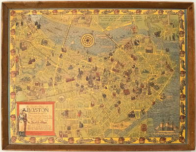
Sold20191950s Garfield Pictorial Map of Boston -- A Scott-MapTitle: 1950s Garfield Pictorial Map of Boston -- A Scott-Map of Boston Massachusetts Date: ca. 1950, Concord, MA Cartographer: A Scott Garfield Size: 20.7 x 27 in. Additional Information: A very attraSee Sold Price
2022A new and correct plan of the town of Boston. Massachusetts. GENTS MAG 1775 mapTITLE/CONTENT OF MAP: 'A new and correct plan of the town of Boston' The map was published to illustrate the Siege of Boston (April 19, 1775 – March 17, 1776), the opening phase of the AmericanSee Sold Price
Sold2017Antique French Map and Plan of Boston, MassachusettsTitle/Content of Map: Antique French Map and Plan of Boston, Massachusetts Date Printed: 1757 Cartographer: Bellin, Jacques Nicolas Size (in): 10 x 6 One of the earliest obtainable town plans of BostoSee Sold Price
Sold2018Tanner: Antique Map of Massachusetts & Rhode IslandTitle/Content of Map: Massachusetts & Rhode Island with insert of Boston by Tanner Date Printed: 1843 Cartographer: H.C. Tanner Material/Medium: Paper Size: 17" x 14" Hand colored engraved Map based oSee Sold Price
Sold20231859 Map of Massachusetts and Rhode Island. Insert of Boston by ColtonTitle: 1859 Map of Massachusetts and Rhode Island. Insert of Boston by Colton1859 Materials: Steel engraved Size: 17 1/2 x 14 1/2” Massachusetts and Rhode Island. With insert of Boston and surroundiSee Sold Price
SoldBOSTON MAPS. Map of the City of Boston, Massachusetts, Published by the City Planning Board.BOSTON MAPS. Map of the City of Boston, Massachusetts, Published by the City Planning Board. Engraved map on paper backed with linen, in black and white with blue, in folding sections with black cardSee Sold Price
Sold2021Plan of BostonPublication Date: 1886 Title: Plan of Boston Cartographer: MITCHELL, SAMUEL AUGUSTUS (JR.) Height (inches): 13.5 Width (inches): 21 26. 27. With inset, "Map of the country around Boston showing also iSee Sold Price
Sold2017US Canada Atlantic & Great Lakes Ports Sea Chart, 1914Title/Content of Map: 'American Atlantic Ports - North Sheet; Inset Chicaco; Boston Harbour; Soo Canals; New York Horbour; Ontario; The Coast from New York to Boston; Buffalo; Montreal; Halifax; NewfoSee Sold Price
Sold2021Whilshire Map, Other MapsWhilshire copy of map, framed 24" x 26", with other maps. Provenance: Kingsley Montessori School, Boston, Massachusetts.See Sold Price
Sold2017Thomas & Andrews: Antique Map of Massachusetts, 1796Map: Massachusetts Date: 1796 Medium: Original copperplate engraving From Morse's Universal Geography by Thomas & Andrews, Boston, 1796 Dimensions: 15" x 12.5" Unframed. Please note that this lot hasSee Sold Price
Sold20231849 1ed Boston Almanac MAP Atlas Calendar Business Directory Illustrated Schools1849 1ed Boston Almanac MAP Atlas Calendar Business Directory Illustrated Schools A rare 1849 almanac of the City of Boston, Massachusetts. This almanac, like many of its era, contains descriptions ofSee Sold Price
Sold2016Map of Massachusetts, Connecticut & Rhode Island, 1868Original engraving from Johnson's Atlas of the World, 1868. Map includes vignette of Boston & details cities, towns and territories. Dimensions: 18" x 26". This item ships from Ocean View, DE.See Sold Price
Jun 06Freeman's | HindmanTHOREAU, Henry David (1817-1862). [The Season Books]. Early Spring in Massachusetts. 1881. --$400
Jun 06Freeman's | HindmanTHOREAU, Henry David (1817-1862). Walden: or, Life in the Woods. Boston: Ticknor & Fields, 1854.$3,000
2 days LeftJasper52EUROPE. General map. Inset table of population & density by country . SDUK 1844$20
BonhamsAN AMERICAN STERLING SILVER PART FLATWARE SERVICE by Tuttle Silver Co., Boston, Massachusetts, m...$2,000(11 bids)
15 hrs LeftJasper521864 Johnson Map of Massachusetts, Connecticut and Rhode Island -- Johnson's Massachusetts,$60
May 26Heartland Artifact Auctions Inc1855 Currier & Greely Boston Massachusetts "Not One Cent" Token$10


![4 Maps: Bradford (1838): Mass., CT, NJ, Boston.: [United States/Northeast] 4 Maps. ++ MASSACHUSETTS. ++ BOSTON. ++ CONNECTICUT. ++ NEW JERSEY. ++ Maps 10, 11, 13, and 16 from T. G. Bradford, “An Illustrated Atlas, Geographical, Statistical, And Hi](https://p1.liveauctioneers.com/179/85723/44107996_1_x.jpg?height=310&quality=70&version=1457209040)


![THOREAU, Henry David (1817-1862). [The Season Books]. Early Spring in Massachusetts. 1881. -- (1 of 1)](https://p1.liveauctioneers.com/197/329405/177652637_1_x.jpg?height=282&quality=70&version=1715364568)


