Sold2023Map of European Russia by J. Walch - 1812 engravingMap of European Russia. Title: Karte des Europaeischen Russland Engraver and cartographer: Johannes Walch (25 November, 1757 - 23 March, 1815). Production date: 1812. Condition: good. With passe-partoSee Sold Price
Sold2023Map of the Turkish Empire in Europe by J. Walch - 1812 engravingMap of the Turkish Empire in Europe. Title: Karte von dem Türkischen Reiche in Europa Engraver and cartographer: Johannes Walch (25 November, 1757 - 23 March, 1815). Description: handcolored engrSee Sold Price
Sold20221851 Tallis Map of European Russia -- Russia in Europe Showing the Territorial Acquisitions SinceTitle: 1851 Tallis Map of European Russia -- Russia in Europe Showing the Territorial Acquisitions Since the time of Peter the Great Cartographer: J Tallis Year / Place: 1851 c., London Map DimensionSee Sold Price
Sold20211855 Colton Map of Russia in Europe -- RussiaTitle: 1855 Colton Map of Russia in Europe -- Russia Cartographer: J Colton Year/Place: 1855, New York Map Dimensions (in.): 14.8 X 11.8 in. Additional Information: This is a very nice map of EuropeanSee Sold Price
Sold2016Russia in Asia, 1851Original engraving by J. Rapkin, published by The London Printing and Publishing Company, c. 1851. Beautiful hand coloring with decorative border. Map features insets of Skorskarskoi Pagost, Troitsk,See Sold Price
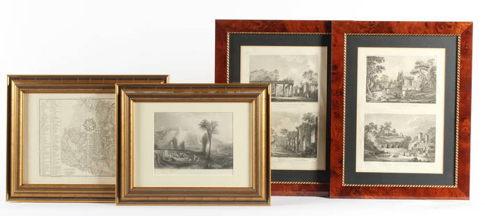
Sold2023Four Antique European EngravingsDescription: Each professionally framed, to include a 1796 map of Milan by J. J. De La Lande, a 19th century steel engraving after J.M.W. Turner of Ehrenbreitstein, and two plates depicting scenes ofSee Sold Price
Sold2017Robert de Vaugoundy: Antique Map European Russia, 1778Title/Content of Map: 1778 Robert de Vaugoundy Map of European Russia -- Partie Meridionale de la Russie Europeenne, Tartarie Russienne, Petite Tartarie par le Sr. Robert de Vaugoundy Date Printed: 17See Sold Price
Sold2018Thomson: Antique Map of European Russia, 1817Title/Content of Map: 'European Russia' European Russia including Baltics Belarus Ukraine. Date Printed: 1817 Image Size: Approx 62.5 x 52.5cm, 24.75 x 20.75 inches (Large); Please note that this is aSee Sold Price
Sold2022European Russia including Baltics Belarus Ukraine. THOMSON 1817 old mapTITLE/CONTENT OF MAP: 'European Russia' DATE PRINTED: Published in 1817 IMAGE SIZE: Approx 63.0 x 52.5cm, 24.75 x 20.75 inches (Large); Please note that this is a folding map. TYPE: Antique early 19thSee Sold Price
Sold20231719 Chatelain Map of European Russia -- Nouvelle Carte des Etats du Grand Duc de Moscovie en EuropeTitle: 1719 Chatelain Map of European Russia -- Nouvelle Carte des Etats du Grand Duc de Moscovie en Europe Partie Meridionale Cartographer: H Chatelain Year / Place: 1719 c., Amsterdam Map DimensionSee Sold Price
Sold20211753 Robert de Vaugondy Map of European RussiaTitle: 1753 Robert de Vaugondy Map of European Russia's Northern Portion -- Partie Septentrionale de la Russie Europeenne ou sont distinguees exactement toutes le ProvincesÂ… Cartographer: D RobertSee Sold Price
Sold20241745 Moll Map of European Russia -- Russia or Moscovy with its Acquisitions &c. in Sweden AgreeableTitle: 1745 Moll Map of European Russia -- Russia or Moscovy with its Acquisitions &c. in Sweden Agreeable to Modern History Cartographer: H Moll Year / Place: 1745, London Map Dimension (in.): 10.2 XSee Sold Price
Sold20231745 Moll Map of European Russia -- Russia or Moscovy with its Acquisitions &c. in Sweden AgreeableTitle: 1745 Moll Map of European Russia -- Russia or Moscovy with its Acquisitions &c. in Sweden Agreeable to Modern History Cartographer: H Moll Year / Place: 1745, London Map Dimension (in.): 10.2 XSee Sold Price
Sold20201790 c. Bell Map of European Russia - Russia or MoscovyTitle: 1790 c. Bell Map of European Russia - Russia or Moscovy Year/Place: 1790 c. Cartographer: A. Bell Size: 6.8 x 8.5 in. Additional Information: A nice map of Russia extending from the White Sea tSee Sold Price
Sold20181867 Johnson's Antique Map of European RussiaTitle/Content of Map: 1867 Johnson's Map of European Russia -- Johnson's Russia Date Printed: 1867, New York Cartographer: A Johnson Size: 22.5 X 16.8 in. Attractive large atlas map of European portioSee Sold Price
Sold2019RUSSIA IN EUROPE. Oblasts.Ukraine Baltics FinlandTITLE/CONTENT OF MAP: 'Russia in Europe' The map shows European Russia west of the "Ouralian" (Ural) mountains, including Finland and Transcaucasia. Vignettes: Polish Captives on their way to Siberia;See Sold Price
Sold20191705 Sanson map of Russia w/huge marginsReserve Reduced! Beautiful specimen with modern hand coloring painstakingly applied. A strongly engraved map of European Russia showing its political divisions, major topographical features, cities anSee Sold Price
Sold2017W & A Johnston: Russia in EuropeMap: Russia in Europe Description: This highly detailed map of European Russia highlights the imperial wishes of the Czars, with Russia's expansion and control of Finland, the Baltics, parts of PolandSee Sold Price
Sold20191729 van der Aa Map of Northern European Russia -- LaTitle/Content of Map: 1729 van der Aa Map of Northern European Russia -- La Moscovie Septentrionale Date: 1729, Amsterdam Cartographer: P van der Aa Size: 8.5 x 11.5 in. A very interesting map of theSee Sold Price
Sold2017Map of RussiaMap of Russia by J. H. Colton & Co. 1857 Size: 14 x 17 in Please note that this lot has a confidential reserve. When you leave a bid in advance of the auction, submit your maximum. Jasper52 will bid oSee Sold Price
Sold2021Bellin: Arctic Coasts of European Russia (2 maps)Title/Content of Map: Bellin: Arctic Coasts of European Russia (2 maps) Date Printed: 1757/1760, Paris Cartographer: Bellin Size: (1) 9 1/2" x 7 3/8"; (2) 12" x 8" Two maps by Bellin of the Arctic coaSee Sold Price
Sold2019A 17th Century Map of Russia.A 17th Century Map of Russia. Hand-colored engraving 14" x 19" Frame: 24.5" x 29"See Sold Price
Sold2019Mitchell: European Russia & ScandinaviaPlace/Date: Philadelphia / 1870 Size: 13 1/2" x 10 3/4" Condition: full color; light overall age toning The beautifully detailed and colored map of Scandinavia and European Russia (encompassing presenSee Sold Price
Sold2019The Times 1895 Lot of 8 European MapsIncl German States, France, Europe Continent, Austria-Hungary and European Russia. Lithograph Maps Published 1895, London for "The Times Atlas" Paper Size: 21 x 16.5 inch (54 x 42cm) A couple with minSee Sold Price