Sold2022Map of Europe Showing Countries As Established at the Peace Conference at ParisPublication Date: c1920 Title: Map of Europe Showing Countries As Established at the Peace Conference at Paris Cartographer: NATIONAL GEOGRAPHIC SOCIETY Publisher: THE NATIONAL GEOGRAPHIC SOCIETY HeigSee Sold Price
Sold2019EUROPE. General map. Inset table of population &TITLE/CONTENT OF MAP: 'EUROPE; inset table of population by country' The top image on the right hand side shows the entire map. To view a close up of the map showing the level of printed detail, pleasSee Sold Price
Sold2018West IndiesReserve Reduced! Title/Content of Map: West IndiesDate: 1835 Cartographer: Bradford, T.G. Material/Medium: William D. Ticknor Size: 7.6 x 9.75 inches Map showing countries separately outline colored.See Sold Price
Sold2024SECOND WORLD WAR. Europe showing air distances. Occupied Poland 1940 old mapTITLE/CONTENT OF MAP: 'Europe Showing Air Distances' DATE PRINTED: March 1940 IMAGE SIZE: Approx 20.5 x 25.0cm, 8 x 9.75 inches (Medium) TYPE: Vintage colour map; Scale 1:25,000,000 CONDITION: Good; sSee Sold Price
Sold20181854 Bartlett Map of Western US and Northern Mexico --Title/Content of Map: 1854 Bartlett Map of Western US and Northern Mexico -- Survey Map Showing the Countries Explored & Surveyed by the United States & Mexico Boundary Commission in the Years 1850, 5See Sold Price
Sold2017Mitchell: Antique Political Map of Europe, 1867Map: Map of Europe, showing its Gt. Political Divisions Cartographer: S. A. Mitchell Place & Date: Philadelphia / 1867/1870 Size: 13 1/4" x 10 7/8" Condition: full color; light overall age toning TheSee Sold Price
Sold2017Malte-Brun: Antique Map of Europe in 1829Title/Content of Map: 1829 Malte-Brun Map of Europe in 1829 -- Europe en 1829 Date Printed: 1829, Paris Cartographer: M Malte-Brun Size: 8.7 X 11.7 in. An attractive map of Europe showing its politicaSee Sold Price
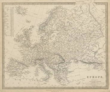
Sold20231891 Mitchell Map of Europe -- Map of Europe…Title: 1891 Mitchell Map of Europe -- Map of Europe… Cartographer: S Mitchell Year / Place: 1891, Philadelphia Map Dimension (in.): 8.2 X 10.6 in. This is an excellent map of Europe. Countries aSee Sold Price
Sold2019Beautiful 1860 map of EuropeMap of Europe Showing its Political Divisions. Clean with good original hand color. 1860 date; from Mitchell’s 1862 atlas. Hint of toning at three edges. 10.75 x 13.375. Reserve: $40.00 Shipping: DoSee Sold Price
Sold20241891 Cram Map of Europe -- EuropeTitle: 1891 Cram Map of Europe -- Europe Cartographer: People's Publishing Co/ G Cram Year / Place: 1891, Chicago Map Dimension (in.): 12.4 X 13.5 in. This is a nice map of Europe, showing its countriSee Sold Price
Sold20181872 Asher & Adams Map of Europe -- Asher and Adams'Title/Content of Map: 1872 Asher & Adams Map of Europe -- Asher and Adams' Europe Date: 1872, New York Cartographer: Asher & Adams Size: 16 X 23 in. An attractive map of Europe showing rivers, lakes,See Sold Price
Sold2017Mitchell: Political Map of Europe, 1874Map of Europe, Showing Its Gt. Political Divisions. S. Aug. Mitchell, Williams, W. 1874. Wide grapevine border. Quarto – 10.60 H x 13.25 W Inches Please note that this lot has a confidential reserveSee Sold Price
Sold2017Mitchell: Political Map of Europe, 1860Map of Europe, Showing Its Gt. Political Divisions. S. Aug. Mitchell, Williams, W. 1865. Roses floral border. Top margin stained. Quarto – 10.60 H x 13.30 W Inches Please note that this lot has a coSee Sold Price
Sold2017The changing borders of Europe 1814-1891Heading: Author: Hertslet, Edward, Sir Title: The Map of Europe by Treaty; showing the various Political and Territorial Changes which have taken place since the general peace of 1814... Place PublisSee Sold Price
Sold2019Rare 1st ed. 1847 ethno map of Europe/AsiaA large full color map of Europe and Asia showing the ethnographic distribution of people. Includes an accompanying chart. From the first comprehensive physical atlas of the world. This map comes fromSee Sold Price
Sold2022HAWES. BEA International Air Routes. 1954. GeorgeHAWES. BEA International Air Routes. 1954. George Philip & Son, Ltd. Second edition. Color offset pictorial system map of Europe and Northern Africa, showing BEA and affiliate routes (Aer Lingus, AlitSee Sold Price
Sold2020Orbis Romani Pars OrientalisTitle: Orbis Romani Pars Orientalis Cartographer: D'Anville, J.B.B. Publication Date: 1764 Publisher: D'Anville Size: Height: 27 Width: 21.5 Map showing eastern Europe or Roman Empire. Details topograSee Sold Price
Sold20181836 Tanner Map of Europe -- EuropeTitle/Content of Map: 1836 Tanner Map of Europe -- Europe Date: 1836, Philadelphia Cartographer: H S Tanner Size: 11.9 x 14.8 in. An attractive Map of Europe, color coding the countries. Both today'sSee Sold Price
Sold2017Charlevoix/Bellin: Voyages of Marco Polo, etc., 1744Carte Pour les Voyages de Rubruquis, Marco Polo, Jen-kin-son etc. A fascinating and highly detailed map of Europe and northern Asia, showing the routes of famous explorers to East, such as Marco PoloSee Sold Price
Sold2017Smith: Antique Map of Asia, 1894Map: 1894 Smith Map of Asia [verso] South Central Europe -- Map of Asia Showing its Geopolitical Divisions, and also the Various Routes of Travel between London & India, China & Japan &c. [verso] AustSee Sold Price
Sold2018Pictorial Map of the American Continent, 1940Title/Content of Map: Pictorial Map of the American Continent Date Printed: c1940 Cartographer: GENERAL DRAFTING CO. Size: 23.6X17.25 Interesting map showing principal products of each country in theSee Sold Price
Sold20221851 Tallis Map of European Russia -- Russia in Europe Showing the Territorial Acquisitions SinceTitle: 1851 Tallis Map of European Russia -- Russia in Europe Showing the Territorial Acquisitions Since the time of Peter the Great Cartographer: J Tallis Year / Place: 1851 c., London Map DimensionSee Sold Price
Sold2023Pictorial map of Oregon TerritoryHeading: (Oregon) Author: Ries, E. Karolyn Title: A map of the Oregon Country showing the Original Territory Place Published: No place Publisher: Date Published: No date [c.1930s] DescrSee Sold Price
Sold2018Lake District.- Ruthven (John) Map of the English LakesLake District.- Ruthven (John) Map of the English Lakes and Adjoining Country Geologically Coloured, geological map showing from Lancaster north to Carlisle, and from Whitehaven to Brough, with four dSee Sold Price
Jun 20The Ross Art GroupOriginal Vintage Chocolat Menier Le Tour de Monde Poster by Jannot 1956 Chocolate Map$500
BonhamsASHER AND ADAMS Asher & Adams' New Historical and Topographical Atlas of the United States. With...£300
22 hrs LeftCedarburg Auction & Appraisals LLCSet of Four Maps Showing All of Spain and Portugal c. 1700's$450(2 bids)
Jun 09Worthington GalleriesAntique H/C Map EUROPE SOUS CHARLEMAGNE EN 814: EMPIRES D'OCCIDENT ET D'ORIENT$25
Jul 11Dan Morphy AuctionsRARE INDEPENDENT GASOLINE & MOTOR OIL FRAMED GRAPHIC HIGHWAY MAP OF ILLINOIS.$125
Jun 08Connoisseur AuctionsEarly 1900's Railway Service Map, Illinois, Ohio, Indiana, Kentucky, Tennessee$20(1 bid)
Featured7 hrs LeftJasper521653 Blaeau Map of the Dnieper River -- Lectori S. Hunc Borysthenis Tractum ut ad Nostrum$850
7 hrs LeftJasper521652 Sanson Map of Parts od Southeast Asia -- Les Isles de la Sonde. Entre Lesquelles sont Sumatra,$200
1 day LeftJasper52La partie méridionale du Brésil et du Perou. SANTINI/D'ANVILLE 1784 old map$80
474 Lots AwayHermann Historica GmbHA porcelain figure showing "Europe on the Bull", Adolph Amberg, 1909 (design), KPM, 20th centurySee Sold Price
Jun 04Mark Louis Weseloh Estate LiquidationsSix - 17th c. Maps of Europe, Asia, England, Germany x2, Crete, Greece.8 1/4" x 6 5/8".$300
Jun 18DOYLE Auctioneers & AppraisersA block puzzle with maps of Europe, England, Ireland, Scotland, America and the World$100


![Smith: Antique Map of Asia, 1894: Map: 1894 Smith Map of Asia [verso] South Central Europe -- Map of Asia Showing its Geopolitical Divisions, and also the Various Routes of Travel between London & India, China & Japan &c. [verso] Aust](https://p1.liveauctioneers.com/5584/108292/55552449_1_x.jpg?height=310&quality=70&version=1503667951)


![Pictorial map of Oregon Territory: Heading: (Oregon) Author: Ries, E. Karolyn Title: A map of the Oregon Country showing the Original Territory Place Published: No place Publisher: Date Published: No date [c.1930s] Descr](https://p1.liveauctioneers.com/642/310901/166355373_1_x.jpg?height=310&quality=70&version=1701367957)


![[MAP]. ORTELIUS, Abraham. Romani Imperii Imago. 1592. (1 of 2)](https://p1.liveauctioneers.com/197/329395/177650537_1_x.jpg?height=282&quality=70&version=1715364962)


