Sold2022Map of Europe Showing Countries As Established at the Peace Conference at ParisPublication Date: c1920 Title: Map of Europe Showing Countries As Established at the Peace Conference at Paris Cartographer: NATIONAL GEOGRAPHIC SOCIETY Publisher: THE NATIONAL GEOGRAPHIC SOCIETY HeigSee Sold Price
Sold2021KOO V.K. WELLINGTON: (1888-1985)KOO V.K. WELLINGTON: (1888-1985) Chinese statesman who was one of the Republic of China's representatives at the Paris Peace Conference of 1919. Koo served as Acting President and Premier of the RepubSee Sold Price
Sold20211952 DECLARATION LETTER in French RELATED TOCOMITE DES DELEGATIONS JUIVES (Committee of Jewish Delegations) , body established at the end of World War I, at the initiative of the Zionist Organization, to alert the Paris peace conference to theSee Sold Price
Sold2017The changing borders of Europe 1814-1891Heading: Author: Hertslet, Edward, Sir Title: The Map of Europe by Treaty; showing the various Political and Territorial Changes which have taken place since the general peace of 1814... Place PublisSee Sold Price
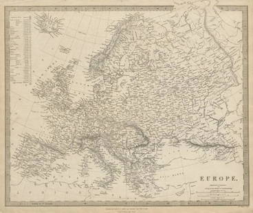
Sold2019EUROPE. General map. Inset table of population &TITLE/CONTENT OF MAP: 'EUROPE; inset table of population by country' The top image on the right hand side shows the entire map. To view a close up of the map showing the level of printed detail, pleasSee Sold Price
Sold2016Portraits of Paris Peace Conference delegates 1920Heading: (Paris Peace Converence 1919) Author: Harris, George W. & Martha Ewing Title: The Peace Conference - Portraits by Harris & Ewing (cover title) Place Published: Washington, D.C. Publisher:HarrSee Sold Price
Sold2020Boucher, Lucien (1889–1971). Air France / Le PlusBoucher, Lucien (1889–1971). Air France / Le Plus Grand Réseau du Monde. Paris: Perceval, 1959. Pictorial map showing the flight path for Air France that reaches globally, vignette borders.See Sold Price
Sold2024POWNALL, Thomas (1777-1805). A New and Correct Map of North America, with the West India Islands,POWNALL, Thomas (1777-1805). A New and Correct Map of North America, with the West India Islands, Divided according to the last Treaty of Peace, Concluded at Paris, 10th Feby. 1763, wherein are particSee Sold Price
Sold2016Hubert Jaillot. Amerique Septentrionale diviséeHubert Jaillot. Amerique Septentrionale divisée en ses principales parties<See Sold Price
Sold2024WW1 Doughboy's Decorated Map HelmetAmazing WW1 7TH Division Soldiers Helmet with map painted map showing England, France and Western Europe. No liner or strap.See Sold Price
Sold2020Engraved Map of the East Coast of AmericaJacques-Nicolas Bellin (1703-1772), "Carte Reduite des Costes Orientales de L'Amerique Septentrionale," Paris, 1757. Hand colored engraved map of the northeast coast of North America, showing what isSee Sold Price
Sold2023MAP OF COUNTRIES KNOWN AS CANADA"Carte des pays connus sous le nom de Canada" (Map of countries known as Canada), dedicated and presented to the Monseigneur le Comte d'Argenson, for the Department of War, showing land owned by the FSee Sold Price
Sold2023Wilson, Woodrow. League Of Nations Covenant: The Peace Conference Committee Signed Photo WWICa. first quarter 20thC. Very good with 18 ink signed autographs below the photo, on the matt. Signed photograph of the men who drew up the League Of Nations Covenant: The Peace Conference Committee.See Sold Price
Sold2022[MANUSCRIPT MAP-FLORIDA & MISSISSIPPI RIVER] Map Showing Raiford's Proposed Artificial River and[MANUSCRIPT MAP-FLORIDA & MISSISSIPPI RIVER] Map Showing Raiford's Proposed Artificial River and Plan to Continue the Western and Southern Inland System of Navigation to Harbors in the Atlantic. [FernSee Sold Price
Sold2023Rare 1925 Map of The Town and Harbor of Nantucket by Phillip L. HallRare 1925 Map of The Town and Harbor of Nantucket by Phillip L. Hall, whimsical map showing the town, harbor, ships, aircraft, and prominent landmarks of the island. Overall 23 in. x 15 in.See Sold Price
Sold2022World.- Bordone (Benedetto di) [World Map], woodcut, [1522].World.- Bordone (Benedetto di) [World Map], early map showing the recent developments in cartography and departing from Ptolemaic models, including open water between the two continents and not joininSee Sold Price
Sold2017Sartine Map of FloridaCarte Réduite des Cotes et de l’Interieur de la Presqu’ile de la Floride. Antoine Sartine (1729-1801).Engraved map. Paris, 1780. 24 x 17 inches visible, 37 x 29 inches framed. This well engravedSee Sold Price
Sold2022Michel Etienne Turgot (1690-1751): Map of Paris, engraved on paper and mounted on wooden frames, ca.Full title: Michel Etienne Turgot (1690-1751): Map of Paris, engraved on paper and mounted on wooden frames, ca. 1739 Description: 320 x 250 cm The twenty plates comprise a large and magnificent detaiSee Sold Price
Sold2024Joseph Pinchon (manner), hand-painted Paris mapJoseph Pinchon (manner), hand-painted Paris map, Manner of Joseph Porphyre Pinchon (French, 1871-1953), Bird's eye view of the 2nd and 8th Arrondissements, watercolor on paper, no signature detected,See Sold Price
Sold2020[SEUTTER, M] 52 Maps of Europe sold togetherSEUTTER,M. 52 Maps of Europe sold together. ca. 1700. Includes. Europa ** Flandria ** Hanoniae ** Belgii **Luxemburg ** Dauphine Five Delpinatus ** Parmensis Et Placentinus ** Transylvaniae ** DucatusSee Sold Price
Sold2016Maison Charles, A Pair of Table Lamps ‘Palmier’, Paris,Steel and brass France, 1960s Maison Charles, Paris, established in 1908 Three-light fixture 6 bulbs are enclosed Height: 78 cm; diameter: 34.5 cm Good condition, fully functional During the 1960s EmiSee Sold Price
Sold2021George Balthasar Probst (1673 - 1748), engraving, viewGeorge Balthasar Probst (1673 - 1748), engraving, view map of "Paris", No. 39, paper size 17 x 47 inches, frame size 25 x 55 inches.See Sold Price
Sold2021Oyvind Fahlstrom, Sketch for World Map, ScreenprintArtist: Oyvind Fahlstrom, Swedish (1928 - 1976) Title: Sketch for World Map Portfolio: Peace Year: 1972 Medium: Screenprint, Signed and numbered in pencil Edition: 150 Size: 33 in. x 41.5 in. (83.82 cSee Sold Price
Sold2016Rare Vintage Map of Afghanistan War Rug: 5'9'' x 7'3''Rare Vintage Afghanistan War Rug showing map of world with Afghanistan at its center from refugee camp in Peshawar, Pakistan. 1997. Size: 5'9'' x 7'3'' (175 x 221 cm). An outstanding and large exampleSee Sold Price
7 days LeftTimeLine Auctions Ltd.Renaissance Stained Glass Panel with the Head of a Male Saint£5(1 bid)
BonhamsASHER AND ADAMS Asher & Adams' New Historical and Topographical Atlas of the United States. With...£300
1 day LeftCedarburg Auction & Appraisals LLCSet of Four Maps Showing All of Spain and Portugal c. 1700's$450(2 bids)
5 days LeftGold Coast Auctioneers17th-19th c. French Wall Art Collection Map City Sea Scapes Scenes etc.$50
Jun 08Simpson Galleries, LLC.JULIUS BIEN (1826-1909) AN AMERICAN CIVIL WAR RECONNAISSANCE MAP, "Map of Texas and Part of New$100


![[MANUSCRIPT MAP-FLORIDA & MISSISSIPPI RIVER] Map Showing Raiford's Proposed Artificial River and: [MANUSCRIPT MAP-FLORIDA & MISSISSIPPI RIVER] Map Showing Raiford's Proposed Artificial River and Plan to Continue the Western and Southern Inland System of Navigation to Harbors in the Atlantic. [Fern](https://p1.liveauctioneers.com/292/250642/130213644_1_x.jpg?height=310&quality=70&version=1654271664)

![World.- Bordone (Benedetto di) [World Map], woodcut, [1522].: World.- Bordone (Benedetto di) [World Map], early map showing the recent developments in cartography and departing from Ptolemaic models, including open water between the two continents and not joinin](https://p1.liveauctioneers.com/5458/252576/131355887_1_x.jpg?height=310&quality=70&version=1655911671)


![[SEUTTER, M] 52 Maps of Europe sold together: SEUTTER,M. 52 Maps of Europe sold together. ca. 1700. Includes. Europa ** Flandria ** Hanoniae ** Belgii **Luxemburg ** Dauphine Five Delpinatus ** Parmensis Et Placentinus ** Transylvaniae ** Ducatus](https://p1.liveauctioneers.com/1124/187577/94368891_1_x.jpg?height=310&quality=70&version=1607095126)


![[MAP]. ORTELIUS, Abraham. Romani Imperii Imago. 1592. (1 of 2)](https://p1.liveauctioneers.com/197/329395/177650537_1_x.jpg?height=282&quality=70&version=1715364962)


![[MAP]. SPEED, John. A New Mappe of the Romane Empire. 1676. (1 of 2)](https://p1.liveauctioneers.com/197/329395/177650541_1_x.jpg?height=282&quality=70&version=1715364962)


